368 iphone apps
It’s hard to overstate the iPhone’s seductiveness. Take me, for instance. For decades, I was unmoved by the Apple mystique, finding the company’s wares a bit too costly for my Yankee sensibilities. And when the iPhone appeared in 2007, I was unmerciful to my various early adopter acquaintances who couldn’t stop blathering about how cool it was. Now I’m apt to be the guy at the party who whips out his
iPhone to show you a neat A.I.S. vessel-tracking app.
It was Apple’s online app store that ultimately sealed my fate as a fanboy. The iPhone is a beautifully designed handheld computer and communications device, and iTunes is wonderfully easy software for keeping one loaded with your desired mix of music, videos, TV shows, and podcasts. But when the apps section (www.apple.com/iphone/apps-for-iphone) debuted in the middle of 2008, the whole tech package went to a level beyond anyone’s expectations. Finding and installing applications created by developers all over the world turned out to be a blast, whether you wanted quick access to The New York Times or a way to record farts and e-mail them to friends. Many apps are free or quite inexpensive, and updating is nearly automatic. By late 2009, users had downloaded over 2 billion copies of over 100,000 available apps.
We’re going to see many more new developments in the months and years ahead, but the phenomenon has already put a smile on many a sailor’s face. While Google, Microsoft, Palm, BlackBerry, and others all build apps systems-and all their smartphones already offer useful e-mail and web access-an iPhone loaded with marine apps can be a tremendously versatile boat tool, even a powerful handheld plotter. I speak specifically of iNavX, an app that capitalizes on so many of the phone’s particular strengths. We’ll start this tour of boat apps there.
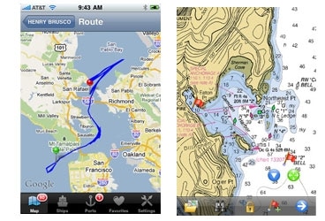
Using either an iPhone’s cellular data service or its built-in WiFi, iNavX can download the latest free paper-chart-like raster charts directly from NOAA’s servers, saving them in the phone’s memory lest you sail beyond any wireless connections. It can also use X-Traverse (www.x-traverse.com) to purchase and download a global portfolio of charts and lake maps from many sources, including Navionics. In most cases, X-Traverse lets you use the same cartography on a Mac running MacENC (www.gpsnavx.com) or a Windows PC running FugawiENC (www.fugawi.com), and it can also synchronize waypoints, routes, and tracks between these and most other charting programs. The iNavX app can also fetch and overlay free GRIB weather files wirelessly. But the real kicker is how it can integrate with a boat’s real-time wind, depth, GPS, and Automatic Identification System data if it’s being served by a WiFi router connected to its instrument system.
Thus it is that my friend Gram Schweikert, now cruising in Central America and beyond on his family’s 62-foot sloop, Visions of Johanna, often stations himself on the bow with his iPhone in a waterproof case as the boat enters a new anchorage. He says that with his iPhone in hand, he can give better tactical guidance from there than he could from the nav station, especially because the phone often gets better and/or more up-to-date charts for iNavX than his current fixed nav system gets. On passage, Schweikert sometimes even uses iNavX to monitor A.I.S. traffic from his berth.
But at $50, iNavX is high end in the app world, and setting a boat up to broadcast its data via WiFi is complex. Many sailors are content with the backup-level navigation offered by Navionics Mobile apps, which are variably priced by chart regions; for example, a Central America and the Caribbean chart costs $20. Mobile can plot your boat on a detailed chart using the iPhone’s rudimentary internal GPS, and it offers nifty graphic tide and current predictions. Its most enticing features, though, relate to the phone’s connectedness and the ability to share data on the fly. You can open a marina icon and dial its phone number with a finger tap; take photos from within the app, and they’re geo-positioned on the chart and easily e-mailed to friends along with your track log; detect a chart error and report it easily to Navionics, with the specific lat/long automatically attached.
Meanwhile, Navimatics’ regional Charts & Tides apps (the prices vary) are somewhat hobbled because the NOAA ENC vector-chart portfolio they use isn’t yet complete, but the 3D-viewing mode introduced in recent updates could become compelling. FlyToMap can also display, all quite inexpensively, NOAA ENCs as well as vector charts of such exotic locations as Bora-Bora. And I have high expectations of Memory-Map, a company that’s already developed excellent nav software for P.D.A.s and Windows smartphones; even an early beta version of its iPhone app pans and zooms charts faster than any of the others I’ve downloaded and tried.
Not necessarily that I’ve tried all the charting apps. Keeping up should be simple as they all funnel through the Apple store, but given that very ease of distribution, plus the financial lure of those 2 billion downloads, the funnel is getting more like a fire hose. Last fall, for instance, Ship Finder was the only app that could plot A.I.S. data collected by coastal receivers. This isn’t iPhone-A.I.S. like Schweikert uses with iNavX. The data is often somewhat delayed, it’s only plotted on the Google maps built into the iPhone, and the receiver coverage provided by volunteers is spotty, but it’s still cool.
At any rate, as I write, three new A.I.S.-viewing apps have joined the fray. Ship Tracking, gTrax, and Fleetmon all differ from Ship Finder in coverage areas, pricing, and features. Some can access online databases of photos and track records and other info that’s not included in regular A.I.S. transmissions.
When it comes to weather, meanwhile, there seem to be at least a dozen developers offering easy iPhone access to NexRad precipitation radar, with the $10 RadarScope being the apparent choice of true aficionados. Specific apps exist for weather-buoy reports, wind predictions, surf predictions, and hurricane tracking, and there are apps for easy access to such popular overall weather-prediction services as BuoyWeather and Weather Underground.
The user reviews that get posted on iTunes can help a sailor find his or her way among the apps chaos, but not always. I’m fond of the $1 Celestial Compass, for example, though it’s been roundly trashed by reviewers. The app delivers graphic local bearings to the sun, the moon, and the Big Dipper. You could use it to check a compass at sea, among other things. I suspect that the negative reviewers expected a real compass and don’t understand the complex calculations underlying this app.
The latest hardware incarnation of the iPhone, the 3Gs, actually includes an electronic compass, and it’s apparently become a key data point for certain racing sailors using the popular $3 app MotionX. In “Dial Up Your Performance” (Sailing World, November/December 2009), its chief developer, well-known sailor Philippe Kahn, explained in depth how his team uses the app to maximize performance. Even the free version of MotionX has a nice GPS “compass” screen and can display the GPS signal strength and accuracy figures not seen in many other nav apps. Much lower profile is the $13 app SailTimer, which, based on your input of waypoint, wind, and boat info, can calculate Tacking Time to Destination and even plot suggested tacks.
Despite its 3.5-inch screen size, the iPhone’s brightness and clarity make it a surprisingly good e-reader, and I’ve gotten into the habit of taking it to my berth after a long day’s cruise. That’s one less light bulb draining the battery, and I had access to an infinity of material, like that New York Times app mentioned earlier. I also could read such book apps as the $5 Boater’s Pocket Reference. It’s easily searched and occupies just a tiny sliver of an iPhone’s memory, and I actually learned a couple of arcane knots from it.
Were I more ambitious, I might’ve burnt the midnight oil using TravelTrac to keep up a cruising blog. Were my yacht much grander, I might’ve used the accessory apps created by KVH or Palladium Systems to access their respective sat-TV and monitoring systems via WiFi. There’s no end to the possibilities. But perhaps the one function I’d most like in my berth, a reliable anchor alarm, serves mostly to highlight iPhone deficiencies. The GPS performance is marginal when one is belowdecks, and imperious Apple has yet to let the phone’s Bluetooth transceiver (great for headphones) talk with Bluetooth GPS receivers. (That’s also true, even more irritatingly, for the iPod Touch, which can run most of these apps but has no internal GPS.) Besides, the iPhone only runs one app at a time, which is a real pain when you’re trying to mind an anchor or, say, track your boat while under way for hours at time.
Those are just a couple of the reasons why some other app phone environment-hello, Google!-could conceivably catch up to the iPhone phenomenon. But then again, we’re just about to experience the Apple tablet phenomenon. As I write, it doesn’t yet have a name or exact specs, but it’s surely going to support iTunes content and apps with a much bigger, yet still portable, screen. Might it be an even more seductive for sailboat use than the iPhone? Quite possibly, I think, and there are several more app tablets in development. So keeping up with worthy cruising apps is going to be even more interesting-and impossible. I’ll keep shouldering away at it on my blog (panbo.com), where your input is always appreciated-but shouldn’t there be an app for that?
Ben Ellison is CW’s electronics editor.