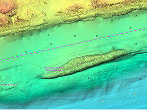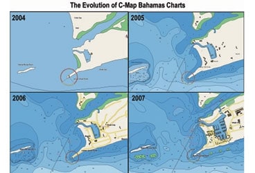
C-map bahamas 368
Two of the biggest names in digital charting recently announced updated charts, aerial and satellite imagery, port information, and updated sounding data for one of the most heavily cruised but poorly charted areas around: the Bahamas. Both C-Map, which is owned by digital-mapping giant Jeppesen, and Navionics now offer mountains of data for very reasonable prices.
Both companies have invested heavily in making these latest versions of their charts as detailed as possible. In fact, the information may be a tad overwhelming at times, but by picking what layers you can see on your plotter or your computer, you’ll be able to separate the wheat from the chaff and add more information as you need it.
Calling either of these company’s products “charts” isn’t accurate. They both use aerial photography, satellite imagery, land-contour elevations, detailed marina diagrams, and, of course, their latest and best vector charts to give even the most inexperienced navigator the tools to successfully sail in these tricky waters.
C-Map and Navionics are well known for their use of the latest imagery technology, and in these products they’ve relied not only on high-flying satellites and aircraft but also on data collected the old-fashioned way. I spent some time working on boats in the Bahamas before digital charting was available, when the classic Explorer Charts were what everyone used. Explorer Charts are still available, of course, and those not choosing to go digital are wise to consider these, rather than government-issued charts. They cover what they call the “Far” Bahamas, the “Near” Bahamas, and the Exumas in five waterproof chartbooks; you can take a closer look at what’s available at the company’s website (www.explorercharts.com). Even if you use digital charts, the Explorer books make a fine companion. In addition, much of the data used by C-Map comes directly from Explorer Charts. Another source for Bahamas paper charts is Wavey Line (www.waveylinepublishing.com). These charts deliver the highest level of detail available for the Turks and Caicos Islands and give sailors additional detail in the outer Bahamas islands and the Dominican Republic as well. Navionics has gotten much of its data from Wavey Line.
Delve into the Details
One of the biggest benefits in these latest C-Map and Navionics products is the extensive number of soundings. Where one used to see huge swaths of light-blue paper or digital screen, there are now spot soundings dotted all about. Put either system into 3-D mode to get a more graphical view of what you’re heading toward. This can be a boon for a navigator with tired eyes or working in low light.
The photographs are reasonably well detailed and show clearly where islands are located. What’s better is that it’s obvious that a great deal of work has gone into geo-referencing everything, which means that if your G.P.S. is up and running, you’re not going to be led astray as many were in earlier days of digital charting, when things weren’t always where the digicharts had them plotted.
C-Map offers animated currents and current predictions, flashing NavAids that depict buoys and other aids to navigation, land-contour elevations, embedded aerial photographs, and diagrams of key marinas. Other enhancements include 25 new C-Marina charts for key Bahamian ports, with detail right down to individual slips. Jeppesen Marine has also added more NavRef aerial photos of Bahamian harbors and inlets; these are designed to provide improved visual orientation for sailors in unfamiliar waters. C-Map MAX works on G.P.S./chart plotters from Furuno, Northstar, Simrad, SI-TEX, Standard Horizon, Cobra, and Interphase.
Navionics parses its data out according to what, in particular, a sailor needs and can afford. The Gold+ version includes accurate and detailed spot soundings, information on ports and marinas, tide tables, and a much information intended to help boaters navigate treacherous waters. Bahamas Special Edition Platinum combines the same highly detailed Gold+ chart cartography and advanced features with Platinum’s 3-D bathymetric views, satellite and high-aerial photography overlays, and panoramic port photography. The Platinum+ version adds high-resolution satellite and high-aerial photography and XGA-resolution port photography. The new Special Edition charts can be used with compatible chart plotters and software available from Navionics partners.
Using the Charts
To see each company’s offerings in action, I used Navionics Platinum+ with Fugawi navigation software and C-Map Max with Nobeltec’s Admiral Max Pro, then plotted a course from Lake Worth Inlet, Florida, to Bimini, then over to New Providence Island; it ended at Little Harbour Bay on Abaco Island. With both charting programs I had all the information I needed to plan a safe, easy-to-follow route and find a marina as well as fuel, food, and even restaurant information. Where the chart data was weak, I was given warnings about inadequate soundings and reported discrepancies. While I’d make sure to carry as much paper information as possible to back up the electronic charting, I’d still feel comfortable using either source for navigating a Bahamas cruise. In fact, I’m hoping that senior editorial staff agree with my premise that the only sensible way to completely check these charts out is to send me down there, preferably next February, on an extended Bahamas chart-checking mission.
Which package is best for you? If you’re buying a new system, the choice is easy: either one. Both C-Map and Navionics work with many different plotters. If you’re planning on using a computer-based navigation system, the answer, again, is either one, depending on which software you purchase.
As longtime readers are aware, I’ve been using Nobeltec in its many iterations for over a decade, which makes it comfortable for me. I also like the fact that, if I choose, I can load every single chart that C-Map offers onto my hard drive and not carry around any extra gear, such as a data-card reader.
On the other hand, Fugawi’s latest version, Marine ENC Version 4.5, has the ability to use both U.S. and Canadian S-57 vector charts; the American charts are free downloads, but the Canadian ones aren’t. While there’s no S-57 data available for the Bahamas, such data is available for other places, and it’s easily updated and useful.
The bottom line for me is this: There’s great cruising in the Bahamas, no doubt about that, and these new products from C-Map and Navionics will help you to get there safely and to enjoy your stay.
Tony Bessinger is Cruising World’s electronics editor.