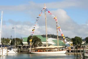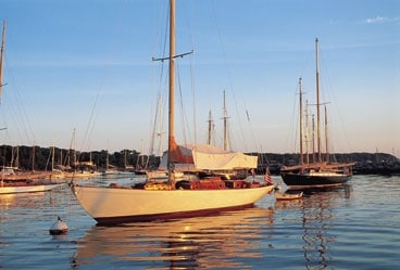
Vinetard Haven wooden sailboats
We were charging toward Nantucket through Great Round Shoal Channel, about finished with a fast sail all the way from Nova Scotia thanks to an offshore tropical depression pumping a northerly gale across the Gulf of Maine. The visibility was excellent, as it so often is in October, the summer fogs of southern New England long gone. To starboard, the low shore of Cape Cod barely rose above the horizon, a reminder that the mainland was near. Yet as we spent time on our late-season cruise to Nantucket and Martha’s Vineyard, the cape’s presence steadily faded until we fell once again under the spell of the islands, each with its own distinct personality.
Soon it was time for us to jibe, and shortly after we did, the flocks of eiders that had been traveling with us went on their way, their white wing patches flashing westward. The wind, now astern, lost its bite, and the rounded dunes of Great Point and its lighthouse slid by to port. Not surprisingly, Nantucket Harbor was empty, with most of the local boats
already on the hard for the rapidly approaching winter. We had the anchorage off Coatue’s First Point all to ourselves.
During the busy summer months when all the moorings are taken or when you simply want to have a beach close by, you can find refuge farther up toward Head of the Harbor, as long as you approach and depart well after low tide. A narrow trough of deep water swings by First Point and digs into a huge bay stretching northward away from the town, marinas, shops, and galleries. Shallows alternating with pockets deep enough for safe anchoring are the norm, so it’s wise to know the state of the tide and to have a good look at the chart before venturing in.
As we gazed up the bay, we wished for a shallower draft. The ponds and sand dunes at the northeastern tip of Nantucket beckoned. The shore birds like the place, too, especially for early summer nesting. That part of the island is exceptionally rewarding when the crowds are gone. Indeed, it’s one of the loveliest spots on the entire U.S. East Coast.
Of course, most summer cruisers head for the moorings off the downtown waterfront because that’s where the action is. Megayachts 100 to 220 feet long moor stern to along the outer seawall of Nantucket Boat Basin. The three-masted, 160-foot Arabella, based in Newport, often completes this amazing array of boats.
Looking Back at Nantucket’s Past
For shopping addicts, Nantucket delivers everything from clothes, books, and pottery to bronze sculptures and paintings for all tastes. But Nantucket offers far more than shopping and plenty of nightlife. A stop at the Whaling Museum will remind you of the island’s historic importance as a center of maritime commerce, most of it linked to the whaling industry. Ships from all over the world’s remotest oceans put in there–150 of them in 1770 alone; that was a typical number when the port was thriving.
Among the museum’s exhibits are carved Polynesian dugout canoes, paddles, and clubs. We found the sailor Valentines amazing. Made of shells, they’re intricate and beautiful. There was also a huge scrimshaw collection. Dramatic scenes scratched on whalebone and teeth show what whaling was really like. It wasn’t romantic, that’s for sure. Rather, it was hard, greasy work punctuated with short periods of sheer terror as the men harpooned the whales, then were towed behind the fleeing whale in their small, open boats at fantastic speeds in what became known the world over as a Nantucket sleigh ride.
We also learned that in the 18th and 19th centuries whaling ships coming in and out of Nantucket had to negotiate a six-foot bar that stretched from Great Point southwestward to Madaket. Supplies and equipment had to be ferried over the bar to ships fitting out on the seaward side, and inbound whalers were forced to unload cargoes into lighters to reduce draft. The whaling fleet was so exposed that when a strong north wind blew across Nantucket Sound, the ships usually ran to Martha’s Vineyard and its well-protected Edgartown Harbor, formerly called Great Harbor.
West to the Vineyard
Listening to the weather forecast, we decided we should sail for Martha’s Vineyard before the next frontal system swept in. Our passage was uneventful and pleasant enough. Knowing that Edgartown Harbor would be packed with moorings, we played it safe and carried on to anchor at the mouth of Katama Bay. The open views, warm water during the summer for swimming, and dinghy access to a landing on Katama Point, close to South Beach, make the bay a prime cruising stop. Perhaps too prime. Unfortunately, after our trip, in the spring of 2004, the bay was closed to all anchoring because of fear that pollution from recreational boats might harm the shellfishing industry there. The closure represents a big loss for cruisers, who now may anchor only in Edgartown’s outer harbor.
Just to the east of Edgartown is Cape Poge Bay, which is only accessible to shoal-draft boats. However, it’s a lovely, well-protected place close to the dunes of East Beach. With chart in hand, steer east from green can “7” to Cape Poge Gut, preferably on a rising tide. You can land your dinghy across the bay in the little Shear Pen Pond. Its name is quite appropriate. In the 17th century, settlers sheared sheep there. The only other way to get onto East Beach is via the Chappaquiddick ferry, then a drive on Dike Road over Chappaquiddick Bridge. A visit to this part of Martha’s Vineyard is well worth the effort.
One of the main attractions of the island is Edgartown, with its sheltered harbor. We tried to imagine what it was like back when whaling was at its height, but it was difficult. With its cozy restaurants and hushed galleries filled with remarkable works of art, Edgartown is a nice port to visit in settled weather, and it’s even better when a gale howls outside.
Moving on, we sailed westward to Vineyard Haven, deciding to bypass the harbor at Oak Bluffs even though we knew it wouldn’t be crowded in October. We’d put in there once before and found its resortlike ambiance a bit too frenetic for our tastes.
However, like much of Cape Cod and the islands, there are interesting stories behind almost everything, and that goes for Oak Bluffs. In the 1830s, Methodist preachers found that the place made an ideal spot to spread their messages of salvation. Thousands of people flocked to the island. Later, on one August Sunday in 1860, approximately 12,000 sinners renewed their spirits at 30 prayer meetings. Politicians eager for public acclaim came too, including President Ulysses S. Grant. Oak Bluffs certainly was–and still is–very popular.
Classic New England Charm
Ferry boats unload thousands of summer visitors at Vineyard Haven, too. It’s as crowded as Oak Bluffs at the height of the season. Yet outside the wharf landings and highway crossroads, the harbor belongs to pretty boats, and that helps make it special. A class of small gaffers nestles inside the breakwaters as well as a number of custom wooden cruising boats. The Gannon & Benjamin boatyard, which still launches new wooden schooners, creates the right ambience. In addition, Vineyard Haven hosts more one-off sailboats than any other New England port outside Maine.
East Chop and West Chop headlands protect Vineyard Haven, except in winds from north to northeast. In the age of sail, when the harbor was once called Holmes Hole and lacked breakwaters, it was a popular spot for windjammers. It was risky at times for these vessels to anchor there. For example, in 1898 a blow known as the Portland Gale stranded 25 vessels all over Vineyard Haven. Today, visiting cruisers can find protection inside the breakwaters or in Lagoon Pond, on the east side of the outer harbor. Enter through an opening bridge and a seven-foot-deep (at low water) channel.
You can find a couple of public landings in Lagoon Pond, such as the launch ramp south of the bridge. However, along the west shore, south of the cages of the shellfish hatchery and behind beached dinghies, stairs lead to wonderful trails on the bluff. Up there, in Ramble Trail Preserve and Brightwood Park, you’ll find unexpected ravines.
Once we arrived in Vineyard Haven, the weather forecast called for yet another strong north wind due within 24 hours. Nevertheless, we were determined to poke around ashore, at least for a couple of hours. We hopped a tour bus, much as we prefer to walk or ride bikes. The wind was from the south and the skies began to rapidly cloud over when the driver, acting also as a witty narrator, pulled into Menemsha.
About 20 years ago, we were allowed to tie up at the fishing wharf thanks to the respect the harbormaster had for an influential resident we came to visit. With a row of fish boats, nets drying, stacks of lobster pots, and gray-shingled gear shacks, Menemsha still smells and feels like a genuine fishing harbor, though the locally designed and built working catboats are gone. There are now slips for recreational boats as well as some moorings, all signs of the changes taking place throughout Cape Cod and the islands, or, as the digitized voice over NOAA weather radio drones, the “cape ‘n’ islands.” The great beaches facing Vineyard Sound on either side of the channel–protected by breakwaters and scoured to a good depth by tidal currents rushing in and out of Menemsha Pond–have long been a major draw for sun worshipers.
Geological Intrigues
The day we were there, though, no sunbathers basked on colorful beach towels. The sky was gray, with low clouds. It began to drizzle. By the time we reached Aquinnah, a wet southwest wind gusted, then subsided, only to gust again as a warm front swept down on New England.
Even on this dismal day, the curiously peaked layers of earth exposed at the Aquinnah cliffs were radiant, each color commemorating the land that had been dry on and off as the sea receded four times through millions of years. A fold of black clay is all that remains of primeval forests. A green strip holds fossilized marine creatures and the teeth of monster sharks, and on top are traces of rhinoceros and crocodiles. The Aquinnah Conglomerate covers it all, its contents arranged according to past sea and land levels–from marine mammals to camels, and later, horses.
The west tail of Martha’s Vineyard also inspired us to think of more recent times. Wampum for sale in the tourist area at Aquinnah is made in Aquinnah village by the Wampanoag people, descendants of indigenous island inhabitants who’d been there long before Europeans arrived and began changing the land. In those days, the islands were covered with mixed forests, but the early pioneers harvested most all the trees for housing, shipbuilding, and to make room for farming.
By morning the skies had cleared, and we left before the cold wind strengthened from the north, as was expected. The islands, we discovered, had so much to offer, which is why they’re so popular. Even with all the summer crowds, a wily cruiser will find secure anchorages and remote beaches. With a dinghy, kayak, or bike, cruisers can enjoy the vast sections of the island that are kept free of development. And the sailing is great on
Nantucket Sound and Vineyard Sound, where the winds blow freely over waters sheltered from ocean swells.
Tom Zydler is the co-author, with his wife, Nancy Schwalbe Zydler, of The Georgia Coast: Waterways and Islands (2001, Seaworthy Publications).