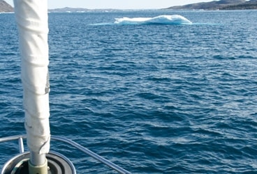
Just beyond the ice floe, the northernmost point of land in North America is a rocky spit called Zenith Point.
Everyone has heard of Cape Horn, the legendary promontory and landmark off the southern flank of South America. For centuries, rounding the Horn has been a highlight in the offshore adventures of many a mariner; for sailors, a successful trip past Cape Horn has been compared favorably to climbing Mt. Everest.
Geographically and even symbolically, at the top of the Americas, a much less heralded point of land serves as the polar opposite, if you will, of Cape Horn. It had never actually dawned on me to search out an atlas to ascertain the northernmost tip of North America, though obviously, there had to be one. So it was pretty surprising during our ongoing transit of the Northwest Passage when we came around a bend aboard our 64-foot cutter, Ocean Watch, and the very aptly named Zenith Point was right there in front of us. Suddenly, something I hadn’t even heard of beforehand became a highlight of my own sailing career and a memorable moment in our ongoing voyage around the Americas (www.aroundtheamericas.org).
We’d left tiny Gjoa Haven a couple of days earlier on what was going to be the trickiest stretch of our journey to date, a northward jaunt through Larsen Sound, Franklin Strait and Peel Sound. The latter had been choked with ice almost the entire summer, but in mid-August a lead opened up and we pointed Ocean Watch north. The mountain-climbing analogy worked here, too: Gjoa had been base camp, and now we were heading for our “summit” of the Northwest Passage.
There was still plenty of ice in Peel but we took it slowly and deliberately and made our way through. For weeks we’d been looking at the related charts of the region and had hoped we might be able to take a “shortcut” halfway up the Sound, through a narrow waterway called Bellot Strait that intersected Boothia Peninsula, to the south, and Somerset Island to the north. When we took off from Gjoa, the ice reports indicated that Bellot was choked with ice and impassable. Then, remarkably, the night before it was in our figurative sights, we received word that Bellot had opened up. It would save us both time and miles.
Very tentatively, we made our way into Bellot, dodging a few tiny floes in the process. But once we were a couple of miles into the roughly 12-mile-long Strait, it was obviously largely ice-free. Our timing proved impeccable; we’d arrived at slack water and the first inklings of the new current were in our favor.
At just about the midway juncture, Zenith Point came into view. Unlike the majestic Horn, Zenith was a nondescript spit of rubble that sloped gently into the sea. But despite its unexceptional characteristics-there was an unlit day marker, but it needed some attention-Zenith represented a mighty achievement in our travels. Once we had it abeam, all the Americas-North, South and Central-were hard to starboard.
The current was ripping and sped us along at speeds up to 14-knots as we emerged from Bellot into Prince Regent Inlet. The hardest part of our Northwest Passage trip was behind us. In more ways than one, we’d reached the Zenith.