Ocean Watch Ice Capades 368
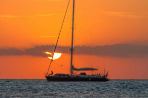
Let’s put it this way: It was one discouraging e-mail. Outside the hotel-room window in Nome, Alaska, the storm-tossed Bering Sea was a portrait of frothy gray; inside, the scene wasn’t much sunnier. Thanks to the powerful northerly winds churning the relatively shallow waters, the ongoing voyage of the 64-foot cutter Ocean Watch-and its bid to sail “around the Americas” via the Northwest Passage (see “North to Northwest,” September 2009)-had temporarily come to a grinding halt. With the boat safely docked in the nearby protected harbor, my fellow OW crewmate, David Thoreson, and I had repaired to a downtown inn-and its halfway decent WiFi connection-to catch up on e-mail and download the latest ice charts.
On a couple of notable counts, it turned into a miserable exercise.
In 2007, Thoreson and the crew aboard Roger Swanson’s Cloud Nine had negotiated the Northwest Passage from east to west in shocking, unheard-of fashion: That summer, the Arctic had experienced a catastrophic, record-setting loss of sea ice, and the fiberglass 57-footer transited the famous northern waterway totally unscathed, never touching a single patch of ice. And Cloud Nine had company, as three other yachts also made it through successfully. The 2008 season brought more of the same, as another seven small boats bagged the once impassable Northwest Passage in nearly ice-free waters.
But there are no givens at any time above the Arctic Circle, and from the very outset of our travels north, which had begun in Seattle, Washington, in late May, it was clear that, in terms of cold and ice, 2009 was going to be a far different, more challenging year than the previous two. The preceding winter and spring had both been significantly colder, and the new sea ice had combined with old floes that had broken free from the ice cap in 2007 and 2008 to form serious choke points at several significant junctures along the Northwest Passage.
“Patience,” said Thoreson, again and again. “We’ll need to be patient. We won’t decide when we can move. The ice will.”
All that was readily apparent by studying the excellent ice charts published regularly by the Canadian Ice Service. It was the first week in July, and clearly we had a long summer ahead of us. But it was an e-mail note Thoreson received that day from a self-professed ice scholar that left me anxious and slightly ill for weeks to come. (I received another strange, discouraging one from a Famous Voyaging Couple not long after that basically echoed the sentiment, concluding with a dismissive “Tisk, tisk.”)
“Too bad about all the ice up there this year,” was the gist of the message, which I’m paraphrasing here. “Looks like you guys are hosed. What’s Plan B?”
Plan B? The whole premise of our goal to sail around the Americas hinged on a successful transit of the historic Northwest Passage (which by strict definition is a voyage over the top of North America, from the Arctic Circle to the Arctic Circle). If we didn’t make it through, the sole alternative was to find the safest harbor possible and spend a long winter encased in ice.
That was Plan B, and frankly, it was mortifying. So we set out on the only premise available: We’d keep going, ultimately bound for Newfoundland and points south, until we couldn’t go any farther. Unnervingly, our progress would come to a literal standstill much sooner than expected.
After a relatively straightforward trip through the notorious Bering Strait, we were just a few miles shy of the Arctic Circle, which lies at 66 degrees 30 minutes north, when skipper Mark Schrader and first mate Dave Logan set a course for the tiny Alaskan community of Shishmaref, on the very exposed northwest coast of the Seward Peninsula. Our travels aboard Ocean Watch are meant to be a “voyage of discovery,” and we were all very curious about Shishmaref. A week earlier, a BBC reporter had visited the place and described it thus: “It is thought to be the most extreme example of global warming on the planet.”
A double-barrel combination of rising seas and melting tundra is causing the tenuous barrier island on which the town of Shishmaref was built, over 400 years ago, to literally vanish. Over the last three decades, temperatures have risen in the Arctic, and the permafrost is thawing. Combined with the northerly winter gales, particularly at times of high tidal surge, the northern shore of Shishmaref is crumbling and being claimed by the sea. Some locals estimate that three to five feet of erosion occur each year, though others guess the figure is close to 10 feet.
Either way, it’s semantics. Shishmaref is disappearing. We wanted to see it for ourselves, and we did get close enough to view numerous homes and buildings sliding into the sea. But the approach to the low-lying isle is poorly marked, the waters surrounding it are thin, and Ocean Watch draws nearly nine feet. Which is why, on a dark night, in a rising breeze, on a lee shore, we went aground.
Luckily, before too long we managed to bounce our steel hull into deeper waters and continue north. But the next heart-stopping experience would prove even more harrowing and also provide a glimpse of coming attractions-and obstacles-for the eventful weeks ahead. For at 70 degrees north, roughly 80 miles south of Barrow, Alaska-the northernmost U.S. town-we sailed, for the very first time, into the ice.
Though we’d eventually learn to negotiate the northern pack ice with a modicum of grace and efficiency and to identify and follow leads through the ice mazes while skirting the impassable blockades and logjams, in this inaugural encounter, our collective familiarity with ice-strewn waters was minimal. Our secret weapon was Thoreson, now on his third trip to the Northwest Passage, who spent hours in the spreaders scouring the horizon for safe routes.
Still, this initial “taste” of Arctic ice left us anxious and unsettled.
We came upon it quickly, after a NOAA plane flew overhead and radioed that ice lay ahead, but there were plenty of navigable leads. Shortly after, someone on board made an innocent-enough observation: “Hey, there’s our first ice!” It was a long, low expanse of pack ice, still a few miles away, and if you didn’t invest much thought into it, the stuff looked no more threatening than a tempting stretch of white-sand beach.
Two hours later, we were more or less surrounded by it. We missed most of the ice, but not all of it. That was an impossible task. Making contact with ice is an interesting experience. The first time you do it, you’re terrified. The second time, less so. The third time, it’s like, dude, whatever. The closer we got to Barrow, the more entrapped we seemed to be. Fortuitously, we’d sailed into the high latitudes and the land of the midnight sun, where the perpetual summer daylight made piloting much easier.
Even off the small town of Barrow, however, the ice was nearly on shore, and the loud reports from the rifles of the seal hunters working the nearby floes seemed like a fitting soundtrack to the entire surreal episode. Well after midnight, nearly a dozen hours into our “ice capades,” we dropped the hook off the open roadstead by the village’s main drag, and everyone took a few deep breaths. The respite was short-lived. Just minutes later, someone shouted from shore, “The ice is coming! Your boat will sink in 10 hours!” That nugget earned our undivided attention, so we hauled the anchor and moved to a safer anchorage off Elson Lagoon, several miles north of town, where our frayed nerves finally found relief.
We’d planned on spending a week or so in Barrow, but that notion proved to be wildly optimistic, as the ice to our immediate east in the Beaufort Sea remained a formidable-and impenetrable-presence through much of July. As it turned out, our forced layover, underscored by a long week of steady 25- to 30-knot easterlies, presented the opportunity to meet some fantastic people, all of whom welcomed us with open arms and shared endless stories and information about life above the Arctic Circle.
From Harry Brower Jr., an Eskimo subsistence-whaling captain whose grandfather was one of the storied Yankee whalers who plied the western Arctic, and his close friend, a wildlife biologist named Craig George, we learned about the bowhead whale, which has played such a prominent role in the history of the region and which now has made a stirring recovery since the mid-1970s, when scientists believed it was on the verge of extinction. Both men drove home the point that climate change in the Arctic-and, more specifically, the loss of the pack ice-has become a real and forceful factor in their everyday work and endeavors over the last 20 years.
In late July, when the receding ice finally allowed us to resume our voyage, that point was underscored when we paid a brief visit to ornithologist George Divoky, the sole human inhabitant on tiny Cooper Island; he’s been making an annual pilgrimage there to study black guillemots for 33 consecutive summers. For the first 27 years, Divoky never saw a polar bear on the island; the pack ice was nearby, and there were countless seals for the taking. But in the years since, as the ice has disappeared-along with their primary source of chow-hungry bears have been a constant and unwelcome presence, coming ashore in search of food. He now carries a rifle at all times and has moved into a small storage shed, abandoning the tents he once used as his camp.
“People ask me if I believe in climate change,” he said, somewhat facetiously. “And I say, ‘No, but I believe in polar bears.’ When I see a polar bear, I know that’s a polar bear. But I also know I was out here for so long and I didn’t see polar bears. So, you know, something’s going on.”
After our stay at Cooper, and finally heading eastward, we found that our progress came in fits and starts, and Thoreson’s early advice invoking “patience” became our mantra. We made our first call in the Canadian Arctic at the old whaling camp on Herschel Island, in the Yukon Territory, then continued onward through Amundsen Gulf, into and out of a narrow, ice-strewn waterway called Dolphin and Union Strait, and on to the small outpost of Cambridge Bay.
From there, it was another 230 nautical miles to Gjoa Haven, so named after Norwegian explorer Roald Amundsen’s stout ship, Gjoa (pronounced JO-ah), aboard which he recorded the first-ever trip through the Northwest Passage in an epic voyage from 1903 through 1906. On this section of the voyage, Ocean Watch zigzagged through a narrow, treacherous waterway called Simpson Strait, the most hazardous waters we experienced since leaving Seattle.
Following a brief layover at Gjoa-which Amundsen described as the “finest harbor in the world”-it was time to push ahead into the hazardous, icy seas to the north: Larsen Sound, Franklin Strait, and Peel Sound, the latter of which had been jammed with ice all season. But the ice charts showed that Peel was beginning to open up, and time was of the essence. Remarkably, a massive high-pressure system had parked over these waters, providing an absolutely perfect, almost unbelievable weather window that would’ve been foolish to squander.
In spirit and execution, this crucial leg was approached like a mountaineer’s final sprint, after weeks of staging, from base camp to summit. For the next 72 hours-and through one final, tense run through thick pack ice-we pushed hard, finally making it as far as Bellot Strait, a slim, 22-mile strait that took us past Zenith Point, the northernmost tip of land in continental North America. Bellot is rarely free of ice, but our timing was impeccable-and lucky. We motored into the strait at seven knots, and a couple of hours later, we were fired out the other end on a ripping current making 14.5 knots. The immediate waters ahead of us, in Prince Regent Inlet, were also free of ice. The worst, most hazardous portion of the Northwest Passage, incredibly, was behind us.
We were out.
A couple of days later, in the last weekend of August, we sailed past the glaciers lining the deep channel of Navy Board Inlet, at the north end of Baffin Island, and dropped anchor off Pond Inlet, our last Inuit port of call. Ahead of us lay a 1,800-mile nonstop voyage to St. John’s, Newfoundland, dodging icebergs and enduring a whopping three-day gale in the Labrador Sea that whipped up formidable seas and sent the 44-ton Ocean Watch careening down the face of one 25-foot wave at 17.5 knots. Sporty!
In the century since Amundsen first tackled the Northwest Passage, roughly a hundred boats have completed the journey; about 70 percent of them have been icebreakers or ice-reinforced vessels. The first “modern” cruising sailor to make it was a tenacious Dutchman named Willy de Roos, who transited from east to west, like Amundsen, aboard his 42-foot ketch, Williwaw, in 1977. In the years since, many more boats have tried than have succeeded, though a couple of dozen intrepid crews pulled it off. That is, until 2007, the year of the catastrophic ice loss, when all four attempts were successful.
In 2009, again, all 11 vessels that sailed north of the Arctic Circle and into the Northwest Passage completed the voyage, a record number. Trust me, it’s still a very difficult sail, and we were thrilled and humbled to be the first American boat that’s completed a west-to-east run in a single season; our own David Thoreson became the first U.S. sailor to make it in both directions. One of the more gratifying parts of the adventure was sharing harbors and bonfires with the crews of two other members of the Class of 2009, the Canadian 40-footer Silent Sound and the French centerboarder Baloum-Gwen. Cruising in company through such extreme cruising grounds, at least part of the time, was a highlight of the summer.
Not all of the successful 2009 vessels were steel workboats like Ocean Watch, the sort of craft one associates with high-latitude voyaging. In fact, a German couple made it through aboard a stock Bavaria 44, and an American family notched it on a Bristol Channel Cutter.
Ultimately, although it took longer in 2009, the leads through the pack ice eventually opened up, and when all was said and done, the Arctic suffered its third largest loss of sea ice ever, right behind 2007 and 2008.
What does it all mean? Allow me to channel my inner George Divoky, the bird man of Cooper Island who may have to abandon his lifelong research there due to the new influx of intruding polar bears.
Aboard Ocean Watch, when people ask us about climate change, we put our answer this way: For the most part, we’re sailors, not scientists, but we understand that cruising boats are running the exalted Northwest Passage in record numbers. We also know of so many excellent sailors who tried in the past on numerous occasions to make this voyage but were turned back by thick, multi-year ice that now is simply no longer there.
So, as Divoky would say-and we’d agree with him-there’s something going on.
Herb McCormick is a CW editor at large.