C07CALLAHAN02.jpg
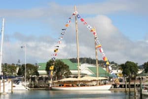
Even as we begin to thrash across the seven miles of open sea between Rockport and the Fox Islands Thorofare in Maines Penobscot Bay, we find that snorkels–if not Aqua-Lungs–would be as appropriate as the wetsuits we wear. My wife, Kathy Massimini, and I are sailing a 16-foot beach cat, and in 15 to 18 knots of breeze with a three-foot chop, the leeward bow dives through crests and flings an inordinate amount of water into the air. The boat accelerates to eight knots, canters over each summit, then plunges. Sometimes our waterproof bags lashed forward of the mast become completely submerged and the boat virtually stops. As her bows rise, sheets of water drain in all directions. I bear off on the sharper peaks, but passing powerboats, heavy-displacement cruisers, and a ferry toss wakes in our path. Im sure the show is entertaining, but we now know weve stored our 160 pounds of gear too far forward, and were not amused. To compensate, I sit so far aft that the tiller extension jams into my side. Kathy snuggles close to me and acts as a human splashguard, taking the brunt of the 50-something-degree spray. Despite her wetsuit, shes already cold. We tell ourselves that if we can just complete the passage, the first of many we have planned on this trip, well be able to dry out, reorganize, and maybe even remember why were out here.
An Unconventional Cruise
I love small boats, and even the Atlantic has been tackled by everything from a dugout to a Hobie 21, but some might wonder how rational it is to cruise a vessel ideally suited to couples sailing from a resort beach. What hooked Kathy and me was an intriguing question. We wondered if a sailboat could match or even enhance the experience to which throngs have flocked in ocean kayaks: that of traversing open water but also trekking the tidal zone and its fascinating, crinkly edges.
For our weeklong expedition, the Escape Sailboat Company loaned us a PlayCat catamaran. Designed by Pete Melvin of Morelli-Melvin, a company thats produced such notables as PlayStation, adventurer Steve Fossetts 125-foot megacat thats shattered several offshore speed records, PlayCats tough, rotomolded, PVC hull, shallow, swept-back keels, and low-aspect rudders are perfect for beaching and for running over lobster pots unfettered. But the PlayCat has no storage compartments, and the trampoline measures just seven and a half by six feet. To customize the boat for cruising, Escape installed an extra gear trampoline forward of the mast, tie-down loops on the tramps, and a reefing system for the sail.
Maines coastline first spun its magic around me in 1967, when I cruised it with my sailing mentor on a 19-foot ODay Mariner. I was a teenager then, and I was entranced by the spectacular interplay of wildlife, granite, evergreens, deep water, and shrouds of fog. Kathy and I have since called Maine home for a quarter of a century, years that have convinced us that one could spend a lifetime exploring its vast coast. Even so, you cant just camp anywhere. Thirty years ago, maybe. But today, Maines swelling population and expanded boating community have inspired most island landowners, even at famed landing spots like Rocque Island (way Down East), to impose tight restrictions or ban landing entirely. Fortunately, Maine is home to Acadia National Park, numerous state parks and public lands, and a plethora of grassroots conservation trusts. Like kayakers, we joined the Maine Island Trail Association (MITA), which manages a 325-mile-long trail from Casco to Machias Bays, with a new extension into the eastern coast of Canada, and provides essential information and access to 39 private islands as well as 49 public islands and mainland sites.
A Cool Beginning
We launch in Rockport, under the shadow of a gigantic replica privateer. The breeze is fresh, and our first wet bash to the cut between North Haven Island and Vinalhaven Island brings to mind multihull designer John Marples’ reminder to his clients: “Cruising a multihull is a lot more about speed management than speed potential.” We’ve averaged better than six knots over the ground to weather, this against the current. It’s clear we’re far quicker than a kayak, but I can’t imagine wanting to drive much faster. In fact, we’re relieved to reach the protected waters of Fox Islands Thorofare, where we turn downwind and slowly slide through, allowing the shivering Kathy to warm up. On our ascent up the learning curve, Lesson One sinks in: Wetsuits are perfect for warmer waters or short stints, but in Maine’s frigid seas, drysuits will be the order of our coming days.
Our first ocean micropassage has given us confidence, though. Our little craft, which weve named simply PC, cuts cleanly through waves and shows no tendency to pitchpole, even when stuffing a nose. Each forestay and opposite shroud yanks tight, then loosens to a sag as PC works over a seaway, indicating some substantial racking of her platform. But the boat appears plenty strong, and the mainsail-only unirig provides plenty of power and remains perfectly tuned no matter how the boat twists underneath. A jib would just be a useless undulating bag, anyway.
In the Thorofares water, flat save for the occasional wake, we pass tiny granite islands capped with spruce, then the village of North Haven. A schooner lies at anchor, people diving off its deck or hanging from the bobstay. We sometimes wander out of the channel, but small wavelets reveal any danger shallow enough for us to hit, so we worry little. On the eastern side of Vinalhaven, PC skates through Carver Cove and close to the rocks along Calderwood Neck. Soon we reach the multifingered waterway off of which Winter Harbor and Seal Bay stretch. Seal Bay offers extremely protected waters, good holding ground, and numerous small islands–two on the trail–as well as ledges, one marked simply by a homemade flag. First passing Little Hen Island, we reach Hay Island tucked up the end of the bay, but with the tide near low, there are no good landing spots. Also, several cruising boats have threaded their way through to anchor, so as dusk nears, we scurry back to the more isolated Little Hen. A mussel-carpeted beach lines the western, weather shore, but the narrow channel protects it from chop. It looks perfect. We drop sail and drift in. When we step off, our feet sink. By the time mine stop, Im knee deep in Maine muck, and I can barely move. After struggling back aboard, we paddle over to the ledges and hang off until we locate the campsite on the opposite shore. Fortunately, Little Hen, like many islands on the trail, delivers an intimate experience on a small scale, so we can scud PC around to land in a miniature cove.
Little Hen Island
By the time we’ve humped our gear a hundred yards over slippery rockweed-bound ledges to the site, we’re knackered. Perfect timing for Lesson Two: Tide rules. I hadn’t thought out how we’d deal with the boat once ashore. PC may have traversed more than 20 miles in an afternoon, but unlike a kayak, we can’t just lift her out of the water or relaunch her at any tidal stage. Fortunately, we carry spare line. Through a block on the end of a short anchor rode, we pass a long loop with its ends tied to a bridle on PC’s bows. From the rocks, we can pull PC out toward the anchor or in to wherever the shore happens to be. To cover the entire tide, we’d need 1,000 feet of line, but a couple of hundred gives us access, at least throughout much of the tidal range. At extreme low tide, PC simply sits on the mud.
By the time weve set up camp, its well after dark, and were exhausted and a bit depressed by the state of our camera gear, which–thanks to a torn seal in one of the dry bags–has taken a bath. This $500 mistake pounds home Lesson Three: Anything required to stay dry must be stored inside a waterproof container in a waterproof bag. Thunderstorms crackle and the forecast is dire, but the campsite is surrounded by thick growth and is well sheltered. We grab a quick bite, climb into our nylon cave, and awake like Scarlett OHara to a new day.
With 30-knot winds whipping the sea and our gear still soaked, we decide to stay put. We intend to sail to a new isle each day, but cruisings true gifts arise from natures dominance over mans petty goals. Our enforced layover gives us time to explore and fall under the spell of cruising so close to Earth, a magic enhanced by the play of tides that dramatically alter the landscape by the hour. Low tide reveals sandbar links between a whole archipelago of stunning islets, so we hike among and around them. Fairy-tale, spiky, impenetrable nanoforests crest foundations of granite sculpted by millennia of ice, wind, and sea. Ive admired these islands many times as Ive sailed past, but viewed from close up, theyre transformed into captivating natural galleries. Rock formations range from jagged fingers to twisted folds, but theyre dominated by smoothly rounded titans of stone that remind me of the sculptures of Henry Moore. I become completely entranced by the interplay of the huge with the minuscule, the ageless and the now. Atop house-sized lumps of granite, piles of purple-and-pearl mussel shells lend evidence to the wisdom of generations of birds: Gulls commonly drop the bivalves from great heights to break them open. As numerous osprey wheel and screech, we return to our simple home nested in the bush, just behind a huge bleached log on which we sit while dining on curried chicken with Turkish apricots and beach peas. I feel strangely secure in this simple life. Suddenly, I feel no hurry to leave.
Kimball Island
When the morning tide rises enough, we load up, skim the mud flats, and head across open water again to Isle au Haut. We ghost along in light air, lounging with our drysuits rolled around our waists, snacking on nuts and dried fruit, scooting by fleets of eider ducks; we’re much closer to ledges than we’d ever dare in a large boat, absorbing the sound and feel of the sea meeting land. Though an adverse tide pushes us up the bay at well over a knot, we still make the seven-mile crossing in two and a half hours, then glide through Isle au Haut Thorofare past osprey whose nests now commonly drape beacons. Since the DDT killoff in the 1950s and 1960s in Maine, these birds have enjoyed a tremendous renaissance.
We pass Isle au Haut village, a Down East charmer with its shingled cottages, gangly docks, and lobster boats, and land on a white-sand beach on the northeast end of Kimball Island. After anchoring the boat, it takes us more than an hour to hike across the island and find the campsite. The trail is littered with countless blowdowns, but it takes us past immense fields of ferns punctuated by granite monoliths and towering spruce. The site faces a ledge- and stone-strewn lee beach unsuitable for keeping or even landing PC. Instead, we return to the Thorofare, sail PC around, quickly yank our gear off in the surf, then sail back. Huge curling wakes from lobster boats and a ferry crash onto the steep beach. If PC is ever caught in the tidal interface as these boats pass, shell be slammed to pieces. That interface is already more than 75 feet from the high-tide line, so wed have to anchor PC out hundreds of yards to keep her safely in the water. Instead, I select skids from the driftwood lumberyard. Yoking ourselves to PC, Kathy and I struggle to yank her up the grade, a few feet at a time. We can barely slog back to the campsite again, now convinced that the bother of setting up and striking camp demands at least a day layover at every stop.
Its nice to set up camp well before dark, though. After dinner, sitting on the ubiquitous driftwood log, we read. I watch the sun set over Camden Hills, just as I did on my first cruise here more than 30 years ago. Back then, we sailed with nothing but a compass and charts, estimating our speed and the current and somehow navigating in dense fog. Though were using GPS on PC, I still bask in a sublime simplicity that tunes me in to the smallest nuances of our surroundings. I delight in the suns last rays spilling through clouds over the water, the delicate sea lavender and other flowers sprouting at the seas edge, the carpets of moss cascading over great bluffs of stone, even the spiky silver sprays of deadwood. In the comfort of a house or even a boat cabin, its easy to forget just how much we miss.
When we return to PC the next morning, the waters edge sits over 100 yards away. Weve slowed down now, though, so we tramp along the shore over much of which weve sailed. I photograph boats squeezing through whats now a tight channel, the sweep of sand shaped by the tidal rips, and a charming lobstermans outpost isolated on a tiny islet. At half tide, we board PC and head for the village-store dock on Isle au Haut, where we tie up and spend the day hiking around the island. On the way home, I set the denim chute by opening my shirt and standing up, increasing our drift with wind and tide.
|
|
| |
|
|
| |
| ©Alison Langley|
| |
|
|
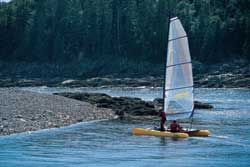
| |
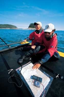
| Steve and Kathy prepare to land on The Hop, a small nub of an island just to the east of Long Porcupine Island.* * *|
| |
|
|
|
Hen Island
To meet next morning’s high tide, we wake at 4:30, cross the island, sail around to toss our gear aboard, and begin a long beat north. Darting through a maze of islands south and east of Deer Isle, we pass no fewer than 15 stops of the Island Trail. We paddle through one gaunt channel that on the chart looks like islands touching, which they do at low tide, admiring ledge and weeds slipping just under us and enjoying views few others see. In open waters, the morning sun gleams off lobster boats that swarm around their pots like bees around spring flowers. With lessons learned, the boat properly loaded, and us toasty in our drysuits, we average seven knots, even close to the wind and against a stiff current.
After first stopping in Brooklin, a mecca of traditional boatbuilding in Maine thats home to WoodenBoat and Professional Boatbuilder magazines, we head for Swans Island. Passing a flotilla of kayakers, were soon blasting along on a reach, fully at home on PC. We reach Seal Cove, where we sail about just for fun before putting in at Hen Island. A party of kayakers has beaten us ashore, but Hen is composed of two islets connected by a field of sea grass, so we claim the northern campsite all to ourselves after setting PC placidly to anchor over flats just offshore. We set up our galley on flat stones on the waters edge, admiring boats anchored behind Buckle Island just to the north. A flood of light from a lowering sun under turbulent skies sets ablaze the greens and pinks of Swans western shore and the scarlet of an approaching kayak. In the great saloon of the outdoors, we joke and speak of boats and Maines past with Swans Island resident Shamis Fastook–he on his boat, we on our rock. In the 18th and l9th centuries, lumber was king, making the now very modest Bangor into the Queen City and one of the wealthiest towns in America. Wooden shipbuilding and granite also were big businesses. Many of these islands are pocked with old granite quarries, which provide superb swimming holes, but Shamis notes that at a few sites, including one around the bend, stone was cut right at the shore and loaded directly onto coastal schooners. Today, most quarries are quiet. Only a handful of schooners still sail, usually lugging human cargo.
Lamoine
Our week is nearly up, so we slip out of Hen the next morning and waft through York Narrows and Casco Passage. It’s sunny and mild as we slide across the mouth of Blue Hill Bay. We surprise a large seal resting on the surface and gain our first real look at Mount Desert Island, with its seaside mountains, its “cottages”–many of which have more rooms than your average hotel–and its expansive woodlands and trails. In a strengthening breeze and on a broad reach, we skirt Mount Desert’s western shore and head up Bartlett Narrows. We slowly outpace a 40-foot cruiser and fly by daytripping kayakers. Hoping to stop at The Hub, twin nubs of rock with a clump of growth on one that hides a campsite, we sail around but find no spot to either haul or anchor the boat, so we press on toward Mount Desert Narrows. Mount Desert is barely an island. A bridge spans what is, at low tide, no more than a narrow estuary snaking its way through expansive mud flats. As we prepare to drop PC’s mast, which is 27 feet high, and paddle through, we notice that the chart promises 25 feet of clearance. With half tide’s extra five feet, we relax and blow through under bare poles. The captain of one of two runabouts that have been waiting for the tide offers us a tow, but as we all float over rocks and mud less than three feet below, PC soon glides faster than they dare travel, so we strike out on our own. Finally in deep water, we set sail again and fly along to Lamoine State Park, in Lamoine, with its many facilities, launching ramp, and our last campsite. It’s not quite the end of our cruise, though.
At my shop in Lamoine, I obtain PVC tubes, over which PC slides up the beach as if greased. For future cruises, Ill support the forward trampoline with one removable PVC tube, with another slid inside. Even so, next time around well also employ fewer base camps and then fully exploit the unloaded boat to explore each area. In that spirit, we sail PC off in the morning to get a closer look at Mount Desert. After a slow, typically windless slog in the lee of Mount Desert, we finally reach the islands surrounding Bar Harbor and creep up on the wind line just beyond. Our romp, when we reach breeze, reminds me that sailing still constitutes one of cruisings greatest joys. PC attacks the whitecaps with surefooted ease. When we edge closer to islands than wed ever dare get in a bigger boat, backwash from the cliffs bounces us around, but in close, we can marvel at the nuances of natural forms, which have varied since Vinalhaven from long humps of smooth rock to jagged organ pipes of it shot with caves. Escaping the backwash, we smoke along, spray atomized by PCs bows. When we tire, we duck in close behind islands like The Hop, a knob where, fittingly, in years past Id partied at an annual all-night summertime bash. Today, a group of kayakers are getting their feet wet, so we beach PC for a chat before turning to sail into the sunset.
A Coming Trend?
When Cruising World convened a panel of designers to explore the future of cruising in the new millennium (see “The Futurists,” October 1999), Chuck Paine suggested that designers and builders had to find a way to tap the qualities that have enticed so many to the world of sea kayaking. Well, the PlayCat is just one of many available boats capable of delivering the camp/cruising experience, economically covering much more ground than a paddle boat and capable of braving even fairly long stretches of open waters. As I write, a friend of ours, Russell Brown, is headed across 20-plus miles of water to explore the Pacific Northwest for several weeks on his 20-foot, Olympic-class Tornado catamaran. Who knows? In time, we may find entire fleets cruising this zone where delight and challenge, as well as the sea and shore, ebb and flow.
At press time, editor at large Steve Callahan and his wife, Kathy Massimini, were on a much larger quest: buying a 40-foot trimaran suitable for travel around the world.