compass 368
Let’s begin with a piece of advice: Don’t cast your compass to Neptune-it’s not dead yet! Of all the navigational tools and instruments employed on boats, the compass is still the single most valuable. Its sole moving part is governed by a fundamental physical force of Earth itself. Electronic instruments communicating with each other and with artificial satellites may provide more information at any time, but the simple compass provides the crucial piece of information that no other device can: the direction the vessel is headed. With that knowledge, anyone aboard the vessel can orient the surroundings-be they sea, sky, land, or all three-relative to the boat and therefore relative to a chart.
Why, in this world of GPS and other networked marvels, is that so important? Isn’t it enough to know where the boat’s going, and isn’t that the same thing?
Well, no. Where the boat’s pointed and where it’s going aren’t always the same. In fact, they rarely are. A current will cause a boat to move over the ground in a direction different from that in which the boat is pointed. Even where no current exists, a boat under sail (and, to a lesser degree, a powerboat) carries leeway, which has a similar effect. Together, leeway and current can cause a boat’s track to be very different from its heading, which can bring unwelcome surprises to a mariner unaware of what’s happening.
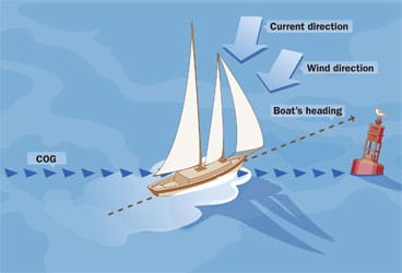
Tim Barker| |Steering by COG without a CompassIn this example, the boat is being steered to a course over the ground (COG) calculated by the GPS. The COG coincides very closely to the GPS’ “Bearing to Waypoint,” making the skipper assume that the boat is bow on to the bouy. On approaching the waypoint, the skipper searches ahead for the red mark, but it’s hidden behind the sails. Without a compass to provide the actual heading, the skipper has been correcting for the current that’s been setting him across his course.|
Let’s take our compass away for a moment and steer the boat toward a GPS waypoint by matching course over the ground (COG) to the bearing to the waypoint. (See “Steering by COG without a Compass,” page 66.) We’re doing well, and the track on the plotter shows our course as a straight line with the waypoint dead ahead. As we approach our waypoint, which happens to be a navigation aid, we begin looking for it to confirm how totally reliable our instruments are. Where should we look? Dead ahead, like the plotter says? Maybe not. We’re on port tack, on a close reach, and making 10 degrees leeway, and a current is also setting us left to right (which we weren’t aware of). The mark isn’t dead ahead; it’s 30 degrees to starboard, behind the genoa. Clang!
If we’d had our compass, we’d have known, from the bearing information provided by the GPS, where exactly to look for the mark, and we wouldn’t now be facing a charge of damaging government property.
No matter what vehicle we’re steering, a fixed reference of some kind is an essential aid to pointing it in the desired direction. A star can serve that purpose as well in life as it can in poetry, but in the absence of stars or distinguishable points on the horizon, the compass is our only option. In fact, it’s a better option than a land-based or anchored reference. (See “The Lubber’s Loop,” page 68.)
While the compass can’t tell us where we’re going, it can tell us what direction we’re steering, which makes it unique. And far from being made redundant by electronic devices, the compass adds to their value. For example, by comparing COG from our GPS to the course steered by the compass, we can detect the presence of a crosscurrent. A little math involving boat speed through the water (from the log), compass course, and COG (magnetic) and speed over the ground (SOG) from the GPS can provide the direction and velocity of that current. Knowing that, we can calculate the course to steer to offset the current, something our GPS can’t do (although it can tell us if we’re off track). The GPS can return the favor by providing a means to check the accuracy of our compass.
Adjusting the Compass
A magnetic compass, as long as it’s in good physical order, will always point in accordance to the magnetic field surrounding it. If that field was the Earth’s alone, it would be utterly reliable, but the compass isn’t monogamous, and it’s easily led astray. Onboard magnetic influences-such as those created in some electrical devices and by iron-cause a compass to point askew from magnetic north, an error called deviation. Deviation can vary depending on what direction the boat lies in relation to the Earth’s magnetic field. An important step when commissioning a new or refitted boat, once its equipment has been installed or stowed in its permanent locations, is to determine what the compass’s deviation is on all headings so that you can apply it to courses you lift off your chart.
A professional compass adjustor will “swing” the compass by checking it against known references, such as a proven range or ranges on structures or geographic features. Once on the range, he’ll have the boat slowly motor along the cardinal directions-north, south, east, and west-as indicated by the boat’s compass while he reads the bearing on the range with a pelorus. Knowing the range’s true bearing and the local variation, he can calculate the compass’s deviation. During the process, he’ll adjust compensator magnets around the compass as necessary to minimize deviation and balance it around the compass rose. He’ll then once again establish the remaining deviation, on at least the eight 45-degree points of the compass, and use those numbers to draw a deviation card. (See “A Sample Deviation Card,” above.)
Posted at the navigation station, the deviation card allows the navigator to convert a course laid on a chart to a course to steer. Conversely, it allows him to correct a bearing taken by the ship’s compass on a landmark to a magnetic bearing. That magnetic bearing can then be plotted on a chart using the magnetic compass rose.
Once the ship’s principal compass has been swung and adjusted, have the adjustor also swing and make up a deviation card for any other compass that might be used for navigation, including the one that supplies heading data to the autopilot.
In the absence of a serious problem that entails moving equipment (cockpit stereo speakers, for example, that are too close to the compass), the process takes about an hour once the boat is on station at the adjustor’s chosen location.
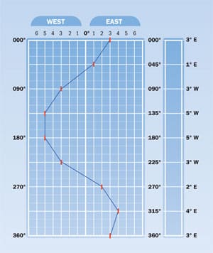
Tim Barker| |A Sample Deviation CardA deviation card allows the navigator to convert a course laid on a chart to a course to steer.|
Deviation by GPS
Prior to the widespread use of GPS, you took compass bearings off recognized features in the landscape and plotted them on a chart to figure out where you were. Your GPS knows where you are, so you take a bearing on a headland you don’t recognize, plot it from your known position on the chart, and voila: “Honey, that’s Dangerous Point off our port bow!”
Because your GPS knows where it is, it can also calculate where it is in relation to any other location in terms of range (distance off) and bearing. And because it comes loaded with magnetic-variation information for the globe, it can tell you that bearing in magnetic notation as well as in true notation. This means that you can use your GPS to check your compass.
Create a waypoint in your GPS with the coordinates of an accurately charted and identifiable feature, say a lighthouse. Set the waypoint as your destination and steer toward it. The farther you are from the waypoint the better, but a couple of miles provides sufficient accuracy. With your boat’s bow on the mark, note the compass heading and the magnetic bearing toward the waypoint from the GPS (not your COG because this will be affected by current). The difference between the heading and the bearing is your compass’s deviation-on that heading. To check deviation all the way around the compass, approach your waypoint from several directions. You may need to use several waypoints to complete the circle.
Some sailboats and a good many powerboats have two helm stations, each with a compass. Only one of these can be the master compass, so you have to designate one. On a sailboat, this would probably be the one you use when motoring. Swing both compasses and adjust both, if necessary. Make a deviation card for the master, then create a relative deviation card for the other by sailing the cardinal and 45-degree points on the master and noting the difference in heading between the two compasses.
Another issue is parallax. This arises when a boat’s steering station is off-center or, on a sailboat, when you steer from the side of the cockpit. If you’re standing behind the starboard helm station and looking over the bow, you’re not sighting down the boat’s centerline. If you aim the bow toward a mark, the boat won’t be heading toward that mark. When swinging the compass, therefore, you should create a sight forward (it could be as simple as a sail tie on the lifeline) the same distance off centerline as the compass. By lining up that sight (let’s call it a lubber mark) with the compass lubber line, you’ll eliminate the parallax error. You might even want to establish a permanent lubber mark to avoid the “lubber’s loop.” (See “The Lubber’s Loop,” left.) The parallax error is significant. On a 40-foot sailboat with twin wheels, the wheels might be 30 inches off centerline and 36 feet from the bow. The resulting parallax angle is 4 degrees.
These are just a few of the ways to get more out of your compass, which to my mind is the single most underrated piece of equipment on any cruising boat.
Jeremy McGeary is a CW contributing editor.