Over the past decade or so, the number of boats cruising the Virgin Islands has grown to the point, some sailors claim, that it is impossible to find an uncrowded anchorage. A couple of years ago, I set out to prove that this is not the case.
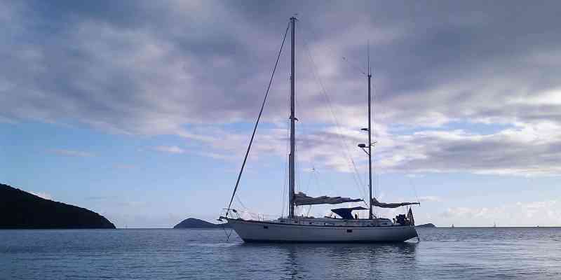
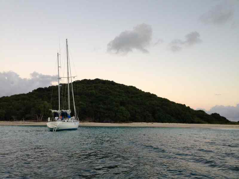
My old friend and shipmate Geoff Curtain lent me his Olympic 48 ketch, Ariel, so I could take family on a 16-day cruise over Christmas and New Year’s — not exactly a quiet time in the Virgin Islands. With me were Trich, my wife of 48 years; our daughter, Dory, and her husband, Scott Vogel; and their two children, Dylan, 22, and Emma Kate, 18. We hit many of the “checklist” spots on a typical Virgin Islands bareboat itinerary, but we also spent many nights in quiet anchorages.
Trich and I had Ariel pretty well ready when the Vogels joined us at American Yacht Harbor, in Red Hook, on St. Thomas. I let the younger men load the heavy stores, and then we sailed east along the south coast of St. John to Salt Pond Bay, where we anchored with three other boats. Sailing by Reef Bay and Little and Great Lameshur bays, we saw only one boat in each of them.
In the morning, we set off on a fast beam reach to Christiansted, St. Croix, making 6.5 to 7 knots at first, and a solid 8 surging to 9 after Dylan and Scott set the mizzen staysail. An exhilarating four-and-a-half-hour sail brought us to Gallows Bay, where we anchored with four other boats.
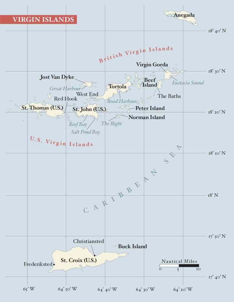
St. Croix
Christiansted is still, in my view, the most beautiful spot in the entire eastern Caribbean. The lower end of the town was declared a National Heritage Area in 1952, and has been restored so it appears much as it did when the Danes built it in the late 18th and early 19th centuries. It is the only principal town in the entire eastern Caribbean that cruise ships cannot visit. The harbor is too shoal, and the sea conditions outside are too rough to ferry passengers ashore from anchored vessels.
The Vogels rented a car for a day and drove along the north shore, through the mahogany forest and on to Frederiksted, another beautifully well-kept town. From there they followed the south coast to East End (the easternmost point of U.S. territory), with a stop along the way at Estate Whim, a renovated, working sugar plantation with a windmill.
The next morning, we anchored Ariel off St. Croix Marine to do some survey work. With Dory operating the GPS for positions, me checking depths with a lead line, and Dylan diving, we ascertained that the wreck marked on the chart was no more, done in by teredo worms and hurricanes. We found no obstructions, so we could report a clear 9 feet (2.7 meters) of depth off St. Croix Marine.
From Christiansted, we sailed the short distance to Buck Island, where we found a big, beautiful 70-foot sloop anchored bow-on to the beach, among numerous small powerboats and sailboats. It was Christmas Eve. All except the big sloop departed before dark.
On Christmas Day, Ariel’s crew mounted an expedition to the marked snorkeling trail in the sheltered water inside the reef at the eastern end of the island. Scott connected with a classmate from New York’s SUNY Maritime College whom he had not seen in 18 years, so a good quantity of beer was consumed.
By day’s end, the big boat and all the day-trippers had departed. We cooked Christmas dinner aboard Ariel, the sole boat in the anchorage.
December 26, Boxing Day, is a holiday in St. Croix, so it was the same story, with lots of day-trippers and a quiet night. Dylan and Scott spent much of the day attempting to kitesurf, without much success.
We would have happily spent three or four more days in St. Croix; nearby Tague Bay, 4 miles long and completely sheltered from the sea by a barrier reef, is perfect for swimming and snorkeling and has plenty of wind for kiteboarding, windsurfing and dinghy sailing. But I had research to do, so on December 27, we headed back to the northern Virgins.
It was a fast sail, but we encountered a setback on the way. While we were charging the batteries, the engine overheated when the raw-water intake became clogged with sargasso weed. Sargasso used to be quite common in the eastern Caribbean but disappeared for decades. It reappeared with a vengeance a few years ago, and piles of it decaying on beaches have become a problem for locals and tourists alike.
Dylan managed to clear the strainer before we anchored in Road Harbour, Tortola, where we cleared in through customs and immigration. We had dinner at The Pub, the old sailors’ standby. I remember it with great affection from the 1960s and ’70s, and it is one of the few places in Tortola that are little changed.
Norman Island
After a morning exploring Road Town, we made a short afternoon sail to The Bight on Norman Island. We knew it would be crowded, but the family of one of Dylan’s mates on the Roger Williams University sailing team owns the William Thornton, better known as the Willie T., the floating bar and restaurant anchored there. After dinner, the Vogels took the dinghy to the Willie T. but stayed for only one drink because of the noise.
I counted 120 boats in The Bight. We anchored in deep water at the entrance. Four motoryachts were anchored astern of us: two ugly, modern megayachts and two beautiful restored classics from the 1920s.
A visit to The Caves, where treasure was found in the 1870s, is a must on a Virgin Islands cruise. The next morning, I had tea and coffee for everyone at 0630. The Vogels were in the RIB before 0700 and returned a little before 0900, having spent an hour and a half exploring The Caves by themselves.
Beef Island
After a huge breakfast of my signature pancakes, we upped anchor and sailed to Inner Bluff Bay, on Beef Island, a favorite anchorage of ours and also of the late Ross Norgrove with his White Squall II. Sailing by Peter Island, we saw no boats anchored in any of the five anchorages on its south coast, two of which (Key Cay and South Sprat Bay) are excellent. Also empty was Little Harbour, where in the 1950s, Sir Brudenell-Bruce, a direct descendant of Lord Cardigan, of Charge of the Light Brigade fame, used his high-powered rifle to discourage boats from dumping garbage in his harbor. The house is now completely overgrown and no longer usable as a landmark.
Inner Bluff Bay is suitable for boats drawing a maximum of 8 feet (2.4 meters). To enter, leave the white Whale Rock to port, eyeball your way to the deepest water, and then anchor bow and stern or with a Bahamian moor to minimize your swinging arc. Leaving Whale Rock to starboard will take you into Hans Creek, which is only suitable for boats drawing 4 feet (1.2 meters) or less. It’s great for multihulls and for windsurfing and kiteboarding.
Inner Bluff Bay is within walking distance of Trellis Bay, where the full moon is greeted with a big party. The Vogels, equipped with a couple of good flashlights, took the slightly rough footpath to take part in the celebrations.
Virgin Gorda
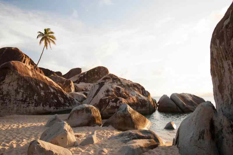
From Bluff Bay we sailed to The Baths on Virgin Gorda. This formation of huge boulders with pools of water underneath them is another checklist stop. It is a huge tourist attraction and gets very crowded, but there is more than one way to skin a cat.
We anchored in Spring Bay, just north of The Baths and within easy dinghy distance. Because the whole west coast of Virgin Gorda is open to the groundswell that can come in unannounced, we anchored bow and stern. We enjoyed an afternoon swim, snacks with sundowners, and a good dinner. After 1700, we had the company of just two boats for the night.
The next morning, I sent the Vogels off in the RIB at about 0700. Trich and I stayed on board. We did not want to ruin the memories we have of The Baths in the ’60s and ’70s, when our yawl Iolaire was sometimes the only boat anchored there. The Vogels had The Baths to themselves for almost two hours before the tourists began to arrive.
After a big breakfast of my other specialty, corned beef hash, with plenty of onions and garlic and topped with fried eggs, we headed to Gorda Sound (or North Sound) in the hopes that, it being New Year’s Eve, one or all of the resorts would put on a fireworks show. We counted well over 100 boats from 30 to 300 feet, from ugly monstrosities to the beautiful 135-foot gaff-rigged schooner Eleonora, a replica of the 1910 Nathanael Herreshoff-designed Westward. A few flares were fired to greet the New Year, but no real fireworks.
On New Year’s Day, after Scott and Dylan again experimented with kiteboarding, we explored Eustatia Sound in the RIB. This is a place to really get away from it all. The sound is 1.5 miles long and protected by a barrier reef that blocks the sea but not the wind. It’s wonderful for diving, kites, windsurfing and dinghy sailing. We saw only four boats.
Access to Statia Sound from Gorda Sound is via the buoyed channel between Bitter End and Saba Rock. Sounding the channel with a pole, we found a short stretch where the depth over the sandy bottom was only 6 feet (1.8 meters) at low tide. Deep-draft boats can enter Statia Sound by passing north of Prickly Pear Island and south of Statia Island. (The name Eustatia appears on charts but is commonly shortened to Statia.)
Jost Van Dyke
The following day we performed a rite of passage by sailing to Jost Van Dyke and Foxy’s Bar. We left Gorda Sound by the passage between Mosquito Island and Anguilla Point. Once through the passage and clear of Mountain Point, we swung west, poled out the genoa, and sailed downwind wing and wing, “reading both pages of the book,” as the old Maine coast schooner skippers would say.
Emma Kate had been our helmsman for much of the time, but as we were sailing dead downwind, and because of the course — almost by the lee — I put Scott on the helm. Scott was bowman on the 12-Meter Stars & Stripes when Dennis Conner won back the America’s Cup in Fremantle. (Dory was navigator for the pace boat, and was the first woman to sail in an America’s Cup elimination race.) When racing, Scott is usually on the pointy end, but he is also a good helmsman, as he showed by sailing Ariel from Mountain Point to Jost Van Dyke without having to jibe.
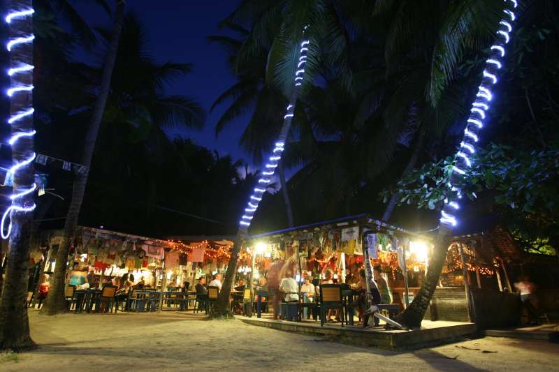
Jost Van Dyke’s Great Harbour was jammed, as expected, but it was a necessary stop. Iolaire was the first foreign yacht to clear into the British Virgin Islands through Jost Van Dyke. That was in 1960, when 18-year-old Albert Chinnery performed his dual roles as customs officer and immigration officer in a building about the size of two telephone booths. He later become famous and was affectionately known as Fat Albert.
As a result of my discovering that you could clear into the BVI via Jost rather than Tortola’s West End, Jack and Ruth Carstarphen, who ran the charter boat Maverick, started to clear in there too, and convinced Foxy’s father to set up a bar to entertain the 12 guests Maverick usually carried. Jack taught the locals how to weave palm fronds into a mat for a roof, and in its shade, Foxy’s was born: four 2-by-10 planks across sawhorses, and beer cooled in a secondhand kerosene fridge that Ruth found in St. Thomas.
We went ashore for dinner at Foxy’s present, rather fancier establishment. It made Dylan’s vacation, as my old friend Foxy joined us for a full half-hour, entertaining us with stories of his life: how he was given a Mickey Finn, shanghaied by Bill Bodle, sailed the world, and met and married Tessa.
The next day, we sailed the short distance to Soper’s Hole Marina, on Tortola’s West End, as the Vogels had to pack and prepare for departure to the cold, cruel north.
In and Out of the Crowds
So ended a wonderful 16-day cruise. We hit the high spots of Christiansted, The Caves at Norman Island, The Baths at Virgin Gorda, and Foxy’s. We also had quiet anchorages at Salt Pond Bay, St. John; Buck Island, St. Croix; and Inner Bluff Bay, Beef Island. Given more time, we would have spent a few days in Tague Bay, St. Croix; Statia Sound, Virgin Gorda; and another of Ross Norgrove’s favorite anchorages, South Sound, on Virgin Gorda.
Cruisers who are not limited to a one- or two-week vacation could spend an entire season in quiet anchorages in the Virgin Islands, joining the crowds only when they felt the need for company. Ariel’s owner, Geoff, and I, cruising around St. John before and after our Christmas cruise, noted very few boats in Round Bay, Great and Little Lameshur bays, Reef Bay, or Francis Bay. We saw no boats in Haulover or Newfound bays on the north coast. Add to that list the numerous underused harbors we didn’t sail past. In Anegada, for example, even when the main anchorage is packed, you’ll seldom see a boat anchored in the cove west of Pomato Point. In normal conditions, and as long as no groundswell is present, you can anchor off the mile-long open beach. Because of the tidal current, I recommend anchoring bow and stern or on a Bahamian moor, especially at spring tides.
Those who linger into early summer will find even more anchorages available to them. I’ve been saying for 60 years that June and July are the best months of the year to sail the eastern Caribbean. The trades blow a steady 10 to 15 knots, no more and seldom less. The groundswell season is over, so Virgin Gorda’s Savannah Bay, and the bays and coves with their fantastic beaches on the north sides of Tortola and St. Thomas, can be used. I rest my case. Those who contend the Virgin Islands are so crowded that it is impossible to find a quiet anchorage are not looking in the right places.
Don Street has been exploring and writing about the Virgin Islands for 60 years. His home and survey vessel for most of that time was his instantly recognizable red yawl, Iolaire, whose fame is perpetuated in the Imray-Iolaire series of nautical charts that cover the Atlantic islands and the eastern Caribbean.


