The National Parks of the U.S. East Coast
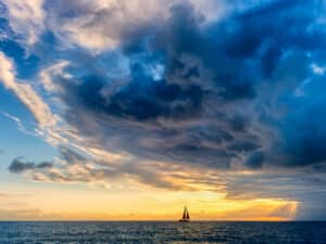
From sighting wild ponies and sea turtles to exploring forts and secluded beaches, some of the best and most unexpected memories made by my family in our four years on board Osprey, our 45-foot steel cutter, haven’t happened in exotic, far-flung locales—they’ve occurred right on the U.S. East Coast at national parks and seashores. We revisit a few of these places every chance we get, and each time, they seem to get better because we always experience something new. Many offer unparalleled scenic harbors and safe havens, and park staffers always seem helpful and welcoming. There’s something truly satisfying about arriving at these locales from the water, because such an entry offers a unique perspective that only sailors can enjoy.
Over time, the four of us on Osprey—Johnny, my husband, and our son, Kaeo, and our daughter, Kailani—have visited half a dozen national parks, seashores, and monuments, sometimes hopping from one to another. This got us to thinking that it would be possible to sail the coast in two- to three-day legs between each park as a way to reel off steady miles without too much effort. If you pick your weather carefully and choose parks close to towns with important stuff like groceries, it’s quite doable to travel from Maine’s Acadia National Park to Florida’s Biscayne National Park, park-hopping all the way. What follows is based on that idea: a loose itinerary describing the parks that we’ve visited over the years. Several excellent state parks also line this route, including one we frequently visit on the Delaware coast. What I’ve listed here is only a smattering of the possibilities: Visit cruisingworld.com/1202parks for a list of all the national parks, seashores, and monuments in between that have a maritime connection.
Acadia National Park, Maine
For my money, this is simply the best national park for cruisers. Unparalleled natural beauty combined with easy, inexpensive access for people on foot makes it simple to stay here. You could spend an entire summer and never get bored or even begin to explore it all. Created in 1913 when President Woodrow Wilson set aside 6,000 acres, Acadia now encompasses 35,000 acres, the vast majority of it on Mount Desert (it’s pronounced like the course that follows dinner, as in ice cream) Island. The most famous anchorages among yachtsmen are Bar, Southwest, and Bass harbors. When we visited here, though, we cruised straight up Somes Sound, whose entrance lies between Southwest and Northeast harbors.
About five miles long, this narrow, fjordlike bay slices into Mount Desert Island, embraced between the steep granite arms of Norumbega Mountain, to the east, and Acadia Mountain, to the west. Seals and dolphins kept us company as we cruised up to a small harbor at Somesville where we dropped the hook among a dozen other boats. It was a quick dinghy ride to the public landing, where cruisers were invited to leave their dinghies on one side; locals took the other. The well-kept grounds included a trash bin and a portable toilet, all surrounded by fragrant balsam firs and saltwater meadows studded with purple and blue lupine in full summer lushness.
View a complete photo gallery here.
From the dock, it was a short walk up a gravel road to the main road and the village of Somesville. Here, we quickly learned about one of Acadia’s greatest assets, the Island Explorer buses. This system of propane-powered shuttle buses traces eight routes through all of Mount Desert, making it possible to handle the mundane tasks of cruising (grocery shopping, using the Internet, and laundry) as well as reaching towns, trailheads, and beaches all for free. In short, the entire park was at our fingertips from this one anchorage. It cost us $5 per person to enter the park on foot with a pass we bought in Bar Harbor that was good for seven days. (Visitors over the age of 62 can get a Senior Pass, which for $10 gives you lifetime admission to all national parks, historic sites, and monuments.) This pass gave us access to the park’s 120 miles of hiking trails, which include climbs up Cadillac Mountain (at 1,528 feet, it’s the tallest eastern coastal peak), as well as such trails as Wonderland, a flat, wooded path to the rocky seaside where lobstermen worked their pots just offshore.
One day, we rented bikes in Bar Harbor and set off with a backpack picnic on the carriage roads, truly one of Acadia’s most lovely and unique features. Built between 1913 and 1940 as a gift from John D. Rockefeller Jr., 45 miles of carriage roads bordered by granite coping stones weave through the park over 17 stone bridges.
Acadia also includes about 2,700 acres on Isle au Haut, an offshore island we visited a few weeks later. We were able to pick up a mooring ball ($10 a night, which we left in the plastic water bottle attached to the pendant) in the Isle au Haut Thorofare, which is the safest way to stay in this narrow anchorage. From here, the public landing is obvious, and walking trails abound on this lovely, isolated outpost.
Statue of Liberty and Ellis Island National Monuments, New York City
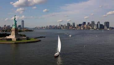
It’s fair to say that these need little introduction. We sailed here on our first summer shakedown cruise aboard Osprey, staying at Liberty Landing Marina, part of Liberty State Park, on the New Jersey side of the Hudson River. From here, it was only a few steps to the ferry to both islands. Cruising sailors have ready access to these sites from the designated anchorage just south of Liberty Island or from any number of the marinas located across the river on the Manhattan side. A good source for such information is Anchorages Along the Intracoastal Waterway from Skipper Bob Publications (15th ed.; www.skipperbob.net/publications), which also gives details on other nearby spots. To be honest, this visit was a little disappointing, largely because cities aren’t our preferred habitat and because we didn’t plan ahead, since we weren’t sure when we’d arrive. It was also about 98 F in the shade, with intense humidity, which made milling about with the thousands of other sweating tourists a little claustrophobic. There’s not a lot of opportunity for spontaneity here; to gain access to any part of the Liberty monument structure, you need reservations well in advance. (Also note that the interior of the statue itself closed in October 2011 for renovations and repairs. The reopening is planned for October 2012.) Even to get to the islands themselves, you’re better off going online and buying tickets ahead of time because on some days, you can expect a two-hour wait just to get ferry tickets. Ellis Island and Liberty Island are free, but the ferry costs $13 for an adult and $5 for a kid. It’s an extra $3 each for access to the statue’s crown and the museum. The park service offers free tours of Ellis Island; the museum there is also free. If you’re willing to navigate all of this, you’re rewarded with a uniquely American experience that leaves many visitors misty eyed.
Cape Henlopen State Park, Lewes, Delaware
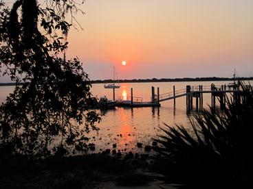
This is one of the two state parks on our list because it’s strategically ideal for cruisers headed south, and it rivals some national parks in terms of scenic beauty and cool stuff to do. Located at the southern entrance to Delaware Bay, across from the better-known stop of Cape May, New Jersey, this park is easily accessible from the anchorage in what’s called Breakwater Harbor, tucked behind the jetty just west of the cape itself. Make sure you anchor well away from the traffic lanes for the Cape May-Lewes ferry, which operates out of a terminal at the harbor’s southern end. Alternatively, you can go into Lewes proper via Roosevelt Inlet, just to the north, and grab a slip at the Lewes Canalfront Park & Marina or City Dock. From here, you have access not only to the park but also to restaurants, laundry, Internet, a grocery store, and all of Lewes’s varied charms. Full disclosure requires I admit that we haven’t anchored Osprey here; we visit Lewes every fall for a week by land yacht. But not a visit goes by that we don’t spot a cruiser or two anchored out behind the jetty while taking a break from their travels.
Cape Henlopen is ideal on foot and especially by bike, and it costs nothing to enter the park by either of these means. A three-mile-long paved trail winds throughout the 5,193-acre park, and you can take some interesting side trips on the sandy, unpaved paths. There are also seven other trails of various lengths ranging in focus from beaches and salt marshes to ponds and dunes, including the Great Dune, standing 80 feet tall.
Sailing into Lewes, you won’t be able to miss the tall, cylindrical towers stationed along this part of the coast. These World War II-era structures served as lookout posts for German U-boats, and we always climb the one that’s open to the public and offers spectacular 360-degree views. Because of its location at the mouth of Delaware Bay, the gateway to the port of Philadelphia, Cape Henlopen was key to coastal defenses during the war. You can explore this military history at the Fort Miles Historical Area, a kind of open-air military park with restored barracks, weapons, and bunkers. Finally, you won’t be the only migrant if you visit here on your way south; located as it is smack on the Atlantic Flyway bird-migration route, Cape Henlopen is a bird-watcher’s paradise. Last fall, we stopped by the Cape Henlopen hawk-watching station and saw this posted on the board: “September 19, a record-breaking day: 1,475 raptors.”
Cape Lookout National Seashore, North Carolina
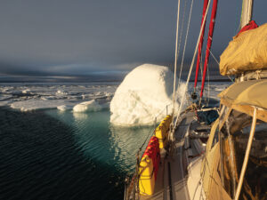
The first time that we visited this amazing place was, in a word, frustrating. We’d motorsailed from Beaufort, North Carolina, a mere six nautical miles away, to Lookout Bight to stage for an offshore run south to Cumberland Island, Georgia. An autumn cold front was barreling through, and it was blowing 25 to 30 knots in the bight, where our anchor held perfectly fine, but launching a dinghy to go beachcombing proved to be a preposterous idea. So much beach, and no way to get there! All that blustery night, the black-and-white, diamond-patterned lighthouse stood sentinel as it has for 152 years, its beam flashing over us. It reassured me, even as my stomach gave way to butterflies at the thought that we’d be leaving at dawn the next day, flying south on all that howling wind. Which is what we did, with the promise that we’d come back and visit that endless beach.
We fulfilled the promise in the spring of 2011 on our way north from Panama, again leaving Beaufort after making a grocery-Internet-laundry stop. This time, the crews of other boats shared the same idea, but this is such a roomy anchorage that we didn’t feel crowded. After we set the hook, launching the dinghy was the first order of business, followed by two days of spectacular kite flying, beachcombing, and bird-watching. Because we arrived on our own boat—the only other way out here is via ferry—it cost us nothing to enjoy the seashore 24/7. We’d hoped for a tour of the lighthouse, but a ranger told us that we were a few weeks too early; lighthouse tours didn’t start until Memorial Day. There’s also a keeper’s house here that dates from 1873, which is home now to exhibits on the islands’ natural and cultural histories. Oh, well, there was always the beach, which seemed to go on forever.
Lookout Bight and the scrap of sand where we made our playground are mere fragments of this enormous national seashore, which encompasses 56 miles of outlying barrier beaches on Shackleford and Core banks. Together, they compose the southernmost end of the famous Outer Banks, and left as they are in their natural state, unsullied by the saltwater-taffy tourism that mars these islands farther north, you can’t help but feel grateful that someone was smart enough to set aside these places for the wild things.
Tucked behind the east end of Shackleford Banks and the fishhook tip of the Core Banks, Lookout Bight is well protected despite being a mile across. From our anchorage we could see the wild ponies that live on Shackleford Banks as they ambled out of the dunes and onto the flat, white sand. In the bight, we had frequent visits from sea turtles, and the rangers told us that so far that spring, they’d located two loggerhead nests on the ocean side.
Cumberland Island National Seashore, Georgia
Some 325 nautical miles south of Cape Lookout, around Frying Pan Shoals and past Cape Fear, lies another national treasure that it’s fair to say is the Osprey family’s favorite—OK, it’s probably a tie with Acadia. Located just north of the St. Marys River entrance on the Georgia-Florida border, 17.5-mile-long Cumberland Island provides a lovely anchorage right next to one of the most magical places that we know. We’ve visited this park three times now and have yet to tire of it, or even see all of it. The 36,415 acres offer ever-changing views of seascapes, dunes, salt marshes, and maritime forest. In its fairy-land forest, where palmettos brush the ground and the twisted, gnarled oaks with their beards of Spanish moss remind me of wise old wizards, I find a depthless, soulful silence.
Sailors making landfall here in the spring can delight in the scent of pine trees and the trill of birdsong. “I heard a wood thrush and a white-throated sparrow,” I wrote at the time. “A red-winged blackbird, which I heard on the way through the dunes, stood perched on a strand of sea grass, singing in the breeze. We’ve had skates jumping in the mornings and evenings, literally doing backflips out of the water, all around the boat, and plenty of dolphins, as usual. We’ve seen two horse herds so far, each with foals. One is a two-week-old Appaloosa that’s just gorgeous, with a big white face and nothing but legs.”
Hundreds of sea turtles nest on these beaches in spring, wild boar and alligators make this their home, and it’s common to see armadillos trundling through the underbrush. The human footprint here is equally varied and fascinating: Native Americans lived here as many as 4,000 years ago, the Spanish built several missions here in the 1500s, and in the 1880s, Thomas M. Carnegie and his wife, Lucy, came here and built the 59-room Scottish castle they called Dungeness. Its ruins and outbuildings today still stand as wild ponies graze on the once-immaculate lawns. On our first visit here, one of the rangers encouraged us to hike past Raccoon Flats, where there were massive mounds of dirt; it was old dredge spoil from the channel. Here, he said, we’d literally trip over fossilized shark teeth. Since then, fossil hunting has become one of our favorite pastimes here, and on a good day, we might return to Osprey with a whole spice jar full of teeth of all sizes and shapes. It costs $4 per person to stay here for seven days (it’s free for children under 16), paid in an honor-box system located at the head of the dock. Like Cape Lookout, this island is accessible only by ferry, and when from Osprey‘s cockpit I watch the last boat of the day leave, I always feel supremely lucky to be able to stay. Also like Cape Lookout, it has a handy town nearby—Fernandina Beach, Florida, which is only five miles to the south—where you can take care of the cruising necessities before you come here for pure peace and quiet.
Fort Matanzas National Monument, St. Augustine, Florida
We stumbled upon this little gem on our first trip south after visiting a friend in St. Augustine, which lies 15 miles to the north on the Intracoastal Waterway. That’s the only way in here; Matanzas Inlet is closed to navigation, not to mention that a fixed bridge and overhead power lines cross it. Most cruisers steam right on by this river on their way either to or from St. Augustine, but we were looking for a quiet place, so we hung a left off the waterway, following Anchorages Along the Intracoastal Waterway‘s advice for negotiating the somewhat shoaly entrance. We were only a couple of hundred yards in when a voice hailed us on the VHF. “You want to get farther to the right there, captain,” he said. “Way you’re headed, you’re gonna hit the bottom.”
We followed the helpful advice and slid without mishap into this narrow, tide-sluiced river, where we dropped the anchor just off the fort, which is on Rattlesnake Island. A little while later, a pontoon boat came rumbling by, and we waved it over. The driver told us that this ferry was the way to the fort and that we could come anytime tomorrow to the visitors center to hop a ride. All of it was free. And yes, he’d been the one who’d saved us from an embarrassing encounter with the bottom. The next morning, we dinghied to the visitors center where we watched a short film about the fort’s history, and then, after a brief walk on the boardwalk that wends through the woods and marsh here, we hopped our ride and headed for the fort. The Spanish word matanzas means “massacres” or “slaughters” and refers to two bloody Spanish attacks on several hundred French settlers here in 1565. In 1589, the Spanish built a wooden watchtower to keep an eye on the back door into St. Augustine, mainly fending off the likes of Sir Francis Drake and a variety of pirates. The actual fort wasn’t completed until 1742, about 50 years after the much bigger Castillo de San Marcos was completed in St. Augustine. It was only intended to hold a small garrison of seven to 10 soldiers who could warn troops at the Castillo de San Marcos of impending attack. We were allowed to explore the fort for as long as we wished. Afterward, we dinghied toward the inlet, where several broad beaches invited us to stretch our legs. On the way we saw sea turtles, dolphins, and even a loon, far south on its migration.
Bill Baggs Cape Florida State Park and Biscayne National Park
For many cruisers heading to the Bahamas or other points east rather than farther south to the Florida Keys, this is the logical end of the line and a good jumping-off point. Bill Baggs Cape Florida State Park occupies the southern end of Key Biscayne, and its No Name Harbor, which offers complete shelter, lies only a one-mile walk from cruising necessities and the public-transportation terminal located at the park entrance. It also has trash disposal, showers, restrooms, free pumpout, easy access to the park’s beaches and walking trails, and a decent restaurant. The downside is that it’s pretty small (and can get predictably crowded), and it costs $15 a night to anchor here, paid in honor boxes on the shore. We anchored outside the harbor and dinghied in; the privilege of tying up is $2 per day. The park itself is beautiful; a minor miracle, really, offering a peaceful, lovely, undeveloped sea and landscape within the shadow of Miami. Its lighthouse was built in 1825, and you can get free guided tours at 10 a.m. and 1 p.m. Thursday through Monday.
Immediately south of Cape Florida lie the boundaries of Biscayne National Park. Its 173,000 acres, 95 percent of it water, contain cays, islands, underwater sanctuaries, reefs, beaches, and mangroves that stretch all the way to Key Largo. Anchorages Along the Intracoastal Waterway provides a thorough listing of the various spots here, and it makes special mention not to anchor in grass or run aground, since fees can be substantial if you damage the bottom or reefs. If you don’t mind running that risk and you watch your weather carefully, you can be rewarded with a truly remarkable place to gunkhole.
Wendy Mitman Clarke and her family are working their way south aboard Osprey_ with their sights currently set on the Caribbean._
View a complete photo gallery.
Find a list of all the national parks, seashores, and monuments in between that have a maritime connection.