MayFeatJobsonSt
Anticipating a landfall generates curiosity in any crew because one never knows what adventures may be in store. Over the past 17 years, I’ve sailed the coast of Maine with my family and many friends, and along the way we’ve visited a hundred or more harbors. Whether we’re stopping for the first time or returning to a familiar anchorage, we always find something new to enjoy.
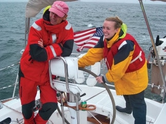
Last summer, aboard our Sabre 402, Whirlwind, few of our guests had visited that coastline before. Watching them experience what I believe are the best cruising grounds on the U.S. East Coast made me appreciate just how special Maine is. My advice? If you’ve never sailed Down East, go. Yes, the fog and rocks can be intimidating, but with GPS, radar, and careful navigation, Maine’s a joy. Spread over the next few pages, you’ll find five of my favorite places to visit. Set sail for Maine, and you’ll soon have a list of your own.
I’d recommend the following books for cruisers interested in heading for Maine: A Visual Cruising Guide to the Maine Coast by James L. Bildner (2006, International Marine), The Lobster Chronicles: Life on a Very Small Island by Linda Greenlaw (2002, Hyperion), The Rockbound Coast by Christopher Little (1994, Norton), A Cruising Guide to the Maine Coast by Hank and Jan Taft and Curtis Rindlaub (4th Edition, 2002; Diamond Pass Publishing), and The Lobster Coast by Colin Woodward (2004, Viking).
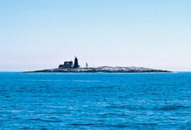
Benjamin Mendolowitz| |Mount Desert Rock| A Visit to the Rock
Lighthouses stand tall; they’re sturdy beacons of navigation and welcome sights. As the distant lighthouse on Mount Desert Rock popped up on the horizon, our crew felt as if we’d made a discovery. Mount Desert Rock (not to be confused with Mount Desert Island) is a tough place to visit; it’s located well offshore, 20 miles south of Northeast Harbor. There’s one large mooring buoy, adequate in light winds, on the northwest corner, and a sloped landing ramp tucked into a nearby cove. I’ve sailed out to Mount Desert Rock six times, but I’ve only been able to make landfall twice. Either way, a visit to this remote place is worthwhile.
The first lighthouse on Mount Desert Rock was built in 1830; it was replaced in 1847 by the current 58-foot tower. This thick granite structure must be mighty sturdy to have withstood a century and a half of storms and the big waves the seabed throws up.
The island is the top of a pinnacle that rises off the ocean floor and was created by retreating ice about 10,000 years ago; the water surrounding the island is well over 400 feet deep. Researchers visit here on occasion, but most of the time the birds have the island to themselves.
Sailing with my family a few years ago, we arrived at Mount Desert Rock on a light-wind day with little swell, though there was a strong current sweeping around the island. Tying up to the mooring buoy was tricky, and it took several tries to get a line through its eye. Once secure, my daughter Kristi and I rowed the dinghy to the landing ramp. Halfway to shore a whale surfaced next to us; it looked big from our eight-foot boat. The whale kept swimming, and I kept rowing. Dozens of seals eyeballed our movements as if they were the guardians of the place.
Ashore, we explored the one-acre island while pondering what life must have been like for the lighthouse keepers. The building suggested a lonely existence. The door was locked, but we could see inside. There was some evidence of people recently staying there. Cadillac Mountain, 25 miles to the north, was visible on this clear day. Seeing land would’ve been a cruel reminder for the keepers of the remoteness of their location. After an hour’s walk, the sea breeze and swell started to build, so we hustled back to the boat for the sail back to the mainland.
Last summer, I returned to Mount Desert Rock with my longtime friend and Etchells partner, Gary Gilbert, who’d never cruised in Maine. On Day Three of our cruise, with the wind blowing 25 knots, we hoisted the mainsail at sunrise and left Frenchboro. It seemed like a perfect day for another visit. When we arrived, the waves were spectacular: eight feet high and breaking on the rocks. I suspect we were the only boat that day to see this powerful sight. Even though landing was out of the question, Gary found the sail to be as rewarding as leading a fleet of Etchells around the windward mark.
Tom Linskey| |The Mud Hole| Pushing East Past Schoodic
For many sailors, Schoodic Point, to the east side of Frenchman Bay and Mount Desert Island, marks the limit of their comfort zone. If they sail farther east, they consider the coast to be too remote, but I’ve found it a fascinating area that deserves exploration.
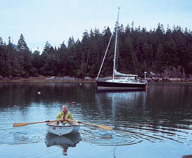
Twenty-five miles east of the point is one of my favorite spots in Maine, The Mud Hole. In spite of its inglorious name, it’s worth visiting for a night or two. More of a creek than a cove, it’s about eight miles south of Jonesport and on the east side of Great Wass Island, home to a Nature Conservancy preserve. The entrance is tricky to navigate and closes off at low tide. Inside, however, there’s 16 feet of water, and more often than not you’ll be the only boat anchored here. It’s a secure hole in a storm.
A year ago, I set sail with three of my best friends: John Martin, Tad LaFountain, Bill Campbell, and I have known each other since we were all 8 years old. They were newcomers to cruising and to Maine. After a day’s march east from Rockland, we arrived at The Mud Hole fighting an ebb tide; just minutes remained until it would be too shallow to enter the creek. I enjoyed seeing the intensity of the challenge on the faces of my friends. We were concerned about running aground, and we knew that if we did, we’d probably spend the night up on the rock. But we made it, to everyone’s relief.
The late summer daylight allowed us time to take the dinghy to the rocky shore a few boatlengths away. We tied the dinghy to the rocks with a long painter so it wouldn’t get hung up, then began to clamber over some slippery kelp. To avoid an accident, we used a line we found tied to a tree to pull ourselves up-a reminder that the four of us were well into our 50s and not as reckless as we might’ve been 40 years ago.
We scaled a 50-foot hill and went for a long hike. Some trails on Great Wass Island stretch for miles in either direction. About an hour into the walk, we came across a clearing with a view of the ocean. A respite was in order, and it offered some time to reflect. Each of us had experienced a very different career-journalist, lawyer, Navy officer, Wall Street analyst-and yet we concluded that the grass wasn’t greener on the other side of the fence for any of us. One’s best friendships often begin at a young age, and even though our careers, family, and geography make our visits infrequent, this cruise easily reaffirmed our bonds.
That night was dark in the shadow of the hills surrounding The Mud Hole. It felt as if we were in a canyon. Above us, the stars jumped out of the sky.
West of us lay the resorts and towns of midcoast Maine. Farther east were more remote destinations: Machias Seal Island, Roque Island, and Canada beyond. The Mud Hole is a place to downshift from high gear to low.
Gary Jobson| |Eggemoggin Reach| Into the Reach
When sailing east or west to any of the harbors along Maine’s midcoast, I highly recommend transiting the inland channel, Eggemoggin Reach. The retreating glaciers did sailors a favor by carving out Eggemoggin. This 14-mile-long stretch is at right angles to the prevailing southwest winds, so you can sail in either direction on a reach in a passageway that features strong wind and smooth water.
There are always interesting boats sailing along Eggemoggin Reach, and it’s easy to get into undeclared races with other sailors. Veteran racers Bill and Sheri Campbell were with us in July, and we were the last of a group of six boats to enter the reach. Bill steered while Janice, Sheri, and I set our new asymmetric spinnaker. As we gained on the fleet, three boats suddenly set spinnakers, too. I love human nature: Nobody wants to be the slowest boat. Nonetheless, Bill soon worked us into the lead.
Two years ago, as the remnants of Hurricane Katrina passed over Maine, my daughter Kristi, my friend Geoff Mason, and I entered Eggemoggin Reach from the east. The wind built to more than 35 knots. Geoff steered Whirlwind as she reached 9.3 knots, a record that stands to this day.
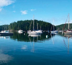
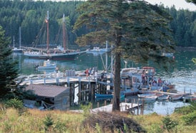
At the northwest end of Eggemoggin sits Bucks Harbor, a must stop. Bucks Harbor Marine is managed by friendly people who are genuinely glad that you’re visiting. Before stopping on a Sunday, I called ahead to reserve a New York Times, and when we arrived later in the day, the newspaper was waiting. This is one of the few harbors in which I allow myself to pick up a mooring. It’s too crowded to anchor here. A short walk from the landing is a well-stocked general store that always brings back nice memories for me.
When we first took our three daughters, Kristi, Ashleigh, and Brooke, to Bucks Harbor, they wanted to meet Sal, the little girl in Robert McCloskey’s famous children’s books, One Morning in Maine and Blueberries for Sal. I didn’t have the heart to tell them that Sal was by then in her 60s. That night, the Bucks Harbor Yacht Club hosted a cotillion. The girls were a little shy at first in this new surrounding, but they eventually joined in the dancing.
No Fire on This Brimstone
About five miles southeast of Vinalhaven Island, is a rare North American volcanic island. A scientist visiting while we were there noted that a similar island lies off Japan. From a distance, Brimstone Island’s 112-foot hill looks like just another Down East island covered with shrubs. But on closer inspection, Brimstone isn’t your run-of-the-mill Maine isle.
At its northwest end is a crescent-shaped beach consisting of smooth, black rocks. Anchoring off the beach is possible, but it’s rolly and exposed.
Last summer, during one of three visits to Brimstone, my plow anchor wedged itself between some rocks. I was
glad that I’d read the recommendation in A Cruising Guide to the Maine Coast to deploy a trip-line; I used mine to pull the anchor out of the rock.
The rocks making up the beach begged to be looked at, and everyone got into it. Our crew, including Janice, and friends Scott Willard and Marilyn Reap, spent an hour collecting stones; each one seemed to have a different personality. Dogs often match their human owners, and on Brimstone, in a similar way, rock hunters find pebbles that match their personalities. We played a game in which everyone brought a favorite rock back to the boat. We put them into a pile, then tried to match the rock to the owner. Interestingly, our crew scored 100 percent. My rock had many pieces to it, reflecting that I have a lot going on-at least that’s what I was told.
There are several narrow trails that work their way to the peak of Brimstone. But be careful: Scott fell into a hole up to his waist. He wasn’t injured, but we all took it a little easier after that. The island’s summit offers fantastic views of Mount Desert Island, to the east; Blue Hill, to the north; and the Camden Hills, to the west.
Alison Langley| |Isle au Haut| A Postcard from Isle au Haut
About 10 miles south of Stonington and Deer Isle sits Isle au Haut, the high island, named by Frenchman Samuel de Champlain in 1604; it’s highest elevation is 556 feet. Only about 60 people live here year-round. In the summer, though, it’s a popular spot, and Janice and I regularly stop to visit. In a remote harbor on the northwest side of the island, adjacent to the Isle au Haut Thorofare, stands a post office the size of a closet. We like to send postcards from here. There’s also a general store where the locals gather. The owners take advance orders for prepared gourmet meals. It’s an impressive place for take-out food.
During our visit last summer, Linda Greenlaw’s ancient pickup truck bounced into the parking lot in a cloud of dust. The woman made famous in Sebastian Junger’s The Perfect Storm was a hit with a group of kids eating ice cream. Linda seemed more petite than I’d imagined from her depiction in Junger’s harrowing tale, but she seemed to fit right into the Down East ebb and flow captured in her account of island life, The Lobster Chronicles: Life on a Very Small Island. After chatting with her, I concluded that she seemed to be a very content person.
Janice and I followed the Arcadia National Park trail that began just past the post office. After about a mile or so, deep in the woods, we came across a couple of rangers clearing brush with a power saw. As we continued walking, the noise quickly faded as it was muffled by the trees.
Isle au Haut has endless trails. At times you feel you could be in the middle of Colorado, and then suddenly you stumble upon the ocean. There might be nicer places to be on a summer afternoon, but it’s hard to think of any.


