Critical marine research
Kim Baldwin knows only too well that if at first you don’t succeed, try, try again.
It was summer in 2008, and the marine researcher had spent just a week of a planned month long stay aboard a catamaran provided by the Moorings charter company in the waters of St. Vincent and the Grenadines. The Moorings was involved in the collaborative effort to support Baldwin’s project-mapping marine habitats in regional waters as part of her doctoral work at the University of the West Indies.
That is, until Baldwin got into an accident that left her with a broken arm.
She headed home to heal, and by August 2009, she was back on the job, aboard a Moorings 4700 cat. “I changed the crew so that this time, I had sailors aboard,” she says. “The first year, the crew members were not sailors, and that was the biggest mistake.”
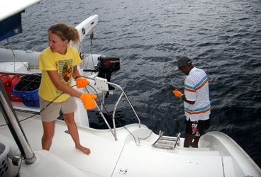
The seven-member crew in 2009 included a fellow marine biologist who is also president of the Barbados Sailing Association and a racing sailor; a local skipper; two local fishermen; and a husband-and-wife team who were Baldwin’s friends and professional yacht crew and volunteered their time as first mate, cook, expense trackers and logistics handlers.
The crew’s focus on the boat made it possible for Baldwin to focus on her work, whose official name is the MarSIS Geodatabase Structure. It involves the creation of an assessable, detailed marine data base that the island countries of St. Vincent and the Grenadines and Grenada can call upon as they seek to enhance and protect the livelihoods of their citizens as well as their natural resources.
Baldwin expects to finish collecting data by November, but will continue to update it as time goes by. “I’ll get my degree but the project won’t end,” she says.
The database, upon completion, also serves another important role.
“It lays the foundation for declaring the Grenadines as a World Heritage site,” Baldwin notes. The two countries embarked on the declaration application with the United Nations Educational, Scientific, and Cultural Organization in the fall of 2009; The data is considered by island government and business leaders a tool that’s integral to their success gaining world heritage status.
Still, we had to ask: When she wasn’t busy with the Garmin GPS, taking lat, lon, and depth measurements, did she ever find time to act like a vacation sailor? “We didn’t have fun like tourists have fun,” Baldwin says. “But we had fun. During our research, we motored. On days off, we found any excuse to have that day off!”
And while she was at it, Baldwin put in a plug for off-season charters, hurricane season notwithstanding: “Low season was good; low wind, calm, flat, it was great.”
For details about the Marine Resource and Space-use Information System, consult the website (www.grenadinesmarsis.com).


