Shyly at first, then blossoming into ethereal shades of pinks and limes and lavenders, the very skies themselves began to dance. As I watched this spectacular light show, the aurora borealis, I understood why the Algonquins call it the Spirit Dance. It was a sign from the Great Spirit himself, a celebration marking our return to Lake Huron’s North Channel.
In the preface to her Well-Favored Passage: A Guide to Lake Huron’s North Channel (1982; Peach Mountain Press), Marjorie Kahn Brazer describes the North Channel as a “flight of the soul to a distant haunt–of peace, of timelessness, of mystery, of aching beauty.” On this trip, my wife, Sharon, and I were joined by our two sons, Shaun, 15, and Adam, 10, and Sharon’s parents, Bert and Lucy Matthews. And on this North Channel sojourn, more than on our first trip here, I felt those very qualities deep in my soul. This was no mere bareboat charter; it was a life-altering experience.
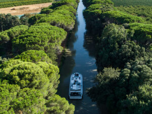
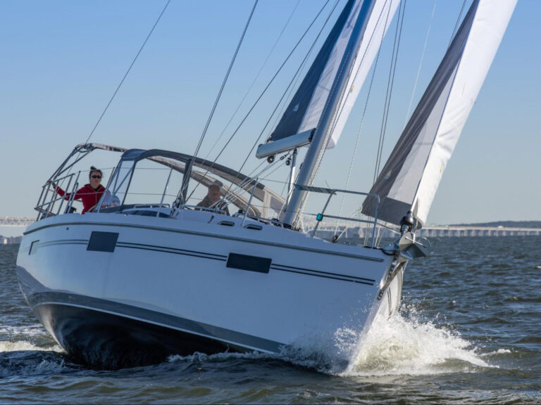
That first visit to the North Channel, in 2002, began on July 1, Canada Day, an appropriate date insofar as the channel is the perfect metaphor for Canada. This is the North Country: massive granite boulders, tree-covered islands, and pure blue water. This is home to Manitoulin Island, the largest freshwater island in the world and, more significantly, the home of the Great Spirit, Gitchi Manitou. Sharon and I and the two boys sat in the cockpit of Rowdy’s Revenge, an Aloha 32 we’d chartered through Canadian Yacht Charters (CYC) in Gore Bay, Ontario, and watched incandescent fireworks, not northern lights–bursts of red, green, and yellow accompanied by cannonades that rumbled through the bilge.
The next morning, I was anxious to be off, but Ken Blodgett, CYC’s proprietor, counseled patience. He spread the chart on a picnic table and suggested anchorages and other points of interest. “Always make sure you know where you are,” he said, indicating a spot that first shows 30 feet of water, then three feet.
Blodgett nodded in the direction of a scuba-geared man on the dock, mask in one hand, fins in the other. “People have been known to, uh, touch here,” he said, pointing to the chart. “My son goes under every boat to make sure everything is sound after every charter.”
We soon learned the channel demands patience. Clouds rolled in before we left the dock. Rain fell in liquid sheets. An hour passed, then two. Sometime around 2 p.m., we got a break. The sun broke through, and I cast off for our first port of call. It wasn’t to be.
A line squall smashed into us right after we passed the headlands outside Gore Bay. I tried to run west past it, but another curtain of rain followed the first. We turned north, but yet another squall line rolled in, followed by thick fog. The rain came in horizontal ribbons, and we limped back into harbor, sodden and discouraged. I erased the rhumb line on my chart and revised my float plan. I’d gone head to head with the channel and decisively lost my first battle, and throughout that first cruise, I was plagued by the thought that I was going about it all wrong.
Return to the Channel
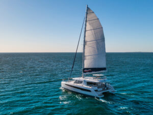
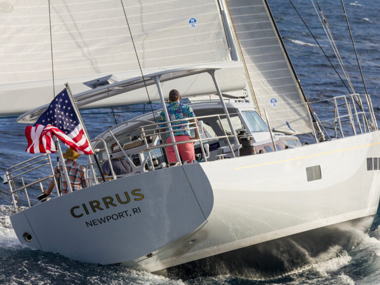
My float plan for the second trip, two years later, was less rigid. In fact, from the minute I stepped off the dock onto the deck of On Purpose, a Hunter 410–also provided by CYC–I felt like I’d come home. On my first trip, I’d scampered around the dock asking others about their favorite anchorages and hearing their lies. This time, I told my own. On this trip, the elements would dictate our course. This time, I’d write my plan in pencil. This time, we’d ride the winds on a beam reach for paradise. With roughly 300 islands to choose from, almost all of them uninhabited, my biggest dilemma would be picking my pleasure.
A sailor setting out from Gore Bay and heading west ends up beating into the prevailing westerlies while crossing the exhilarating expanse of blue water that marks the widest part of the channel. Crack off the wind a bit and you come to Whalesback Channel, a delightful, 17-mile stretch that includes Beardrop Harbour and John Island. Dotted with a variety of islands–some bare rock, some covered in trees–this passage offers plenty of deep water, though you need to monitor your chart and keep an eye out for shoals. Marjorie Kahn Brazer called Whalesback “one of the most beautiful passages in the world.”
But for me, paradise meant the Benjamin Islands, farther east, where we headed via a beam reach in 15 knots of wind, a quick two-hour passage from civilization to pink-granite outcroppings. This time, I knew the entry into the bay at the south end of South Benjamin. This time, we didn’t have to be quite so careful dodging the smattering of rocks called the Sows and Pigs. In this bay, on our first visit, we’d spent our first night out, and it was here that the seeds of a fresh North Channel philosophy began to germinate. Now I lazed in the cockpit, read a book, sipped wine, and inhaled the scent of pine and the smell of wood smoke from a campfire on the shore.
The next morning, I swam in crystal-clear water and sipped another coffee. When the crew woke up, we dinghied over to a 200-foot-high granite outcropping and climbed it to scan the channel, which was visible for miles from this perspective. Our boys swam from a wide ledge far below the ridge, then skipped stones across the water. A single boat headed east, its white sail standing out against the indigo hump of Manitoulin Island. Except for two other boats swinging at anchor in the same bay, we couldn’t see another sign of humanity. We’d found paradise on a beam reach.
We left our anchorage late. Our course on our first trip had been more ambitious: We’d departed by 0800 and made for Little Current, about 30 miles to the east, the track on my GPS straight as an arrow. But this day, we had plenty of wind and buried the rail a couple of times. Still, we covered a mere six miles over the ground, the track on my GPS best characterized as “meandering.” This day, we traveled to a new universe, discovered a new time zone, and learned that the journey is key, not the destination.
The heights of Manitoulin Island marked the southern boundary of this passage, first green in the early morning light, then blue as the sun marched west, followed by indigo in the twilight. The island has long offered shelter from storms that roar up Lake Huron, and it retains a magic that time can’t erase. Though denuded of much of its pristine forest, the island is still a remarkable and friendly destination in its own right, a delightful combination of First Nations land, farms dotting rolling hills, lonely roads, and great stands of new-growth forest.
Manitoulin itself is the last bastion of the Niagara Escarpment, a limestone ridge that marches across Ontario from Niagara Falls. In the middle of the channel, low-lying wooded islands give way to the majesty of pink-granite outcroppings, while farther north, you get true Canadian Shield geology, with alabaster quartzite heights, such as the La Cloche Mountains, thrown in for diversity.
Although aborigines had been here for 9,000 years, no major settlements were established, so European explorers used the waterway primarily as a fur-trading route to territories farther west. The first European reportedly landed here around 1610, followed shortly thereafter by Jesuit missionaries. Channel cruisers can still see remnants of the Jesuit school at Wikwemikong, on Manitoulin’s eastern side, and an ancient roofless structure squatting on a low-lying island just west of Little Current.
Land of the Haweaters
European farmers arrived in the early 19th century. Unfortunately, the thin soil and the granite outcroppings that create such a beautiful cruising ground make the entire region bad for farming. The dearth of arable land gave rise to the appellation “Haweaters” for islanders past, who supplemented their meager diets with the plentiful, if somewhat bitter, hawberries. Today, the term lives on, and the annual August bash held in Little Current is known as the Haweaters’ Festival.
By the late 1800s, lumber had become king. Islands still bear the scars of that depredation. The vast forests you glide past have regrown since lumbering died out. No primary-growth forest remains. Much of the land has been ceded to First Nations tribes, and this accounts for the lack of cottages and other development on the islands in these pristine waters.
For all its beauty and its wealth of secret anchorages, the channel is also a great place to cruise because you can provision within 30 miles of anywhere you’ve anchored. Gore Bay, where CYC is based, is on the western side of a deeply recessed bay. It’s ideally suited for provisioning, and CYC itself maintains a well-stocked chandlery. If you go ashore here, check out the museum housed in the old jail or rent a bike and head out West Bluff Road to one of the oldest lighthouses on Manitoulin.
Victorian Kagawong
Between Gore Bay and Little Current, the pretty little town of Kagawong boasts prime Victorian architecture. Stretch your legs by hiking the Cup and Saucer Trail, sampling its panoramic views of the channel, then take a dip at the foot of Bridal Veil Falls. Little Current features a variety of shops, many of which sell First Nations artwork. Spend a day strolling tree-lined streets, watching boats negotiate the swing bridge that connects the island to the mainland, or simply playing darts while sipping a cool one on the patio at the Anchor Grill.
Wikwemikong and Manitowaning, farther east on Manitoulin, offer fascinating glimpses of First Nations culture. Tie up at the town docks in Manitowaning and tour the 200-foot steamship Norisle, a fine example of the ships that once sailed the Great Lakes. Check out the Assiginack Museum, another attraction housed in a former jail. Sample some summer theater at the Burn’s Wharf Warehouse.
If you want even more culture, First Nations style, visit De-Bah-Ja-Mah-Jig, a fascinating dramatic production that relates the area’s aboriginal heritage. Dock overnight at Wikwemikong Bay Marina, a gorgeous log structure with 60 slips operated by local First Nations bands. If you venture to the channel’s northwesterly reaches, pull into the new marina facilities at Blind River, the largest town on the channel, and provision there.
For all the charm of the villages, though, it’s the wilderness setting and deserted, unspoiled anchorages that keep people coming back to the channel.
Roughly 70 miles east of the Straits of Mackinac in northernmost Michigan, the North Channel demands a significant investment of time for cruisers determined to cruise there from Chicago, Detroit, or other points to the south. If achieving Nirvana was easy, everybody would do it, and there’d be little to brag about once you gained it. From the east, you must traverse the length of Lake Huron. You can either hug Huron’s Canadian coast, which can mean constant cross seas and nasty waters north of Tobermory, at the tip of Ontario’s Bruce Peninsula, or you can stay in the Michigan lee.
Those who head north up the Canadian shore should cross into Georgian Bay and make for such attractive anchorages as Baie Fine, a 17-mile-long fjord, or pull into Killarney and watch the world go by before heading west for the main waters of the channel.
After a long, arduous passage, you may want to book a shorebound berth at the Killarney Mountain Lodge and Outfitters, a rustic family inn with a sailor-friendly atmosphere. Lodge director Jennifer East keeps her 24-foot Shark sloop at the dock here. Should you decide to spend a night ashore, you can dock your boat right in front of the resort, or stay aboard and avail yourself of the comfortable berths and hot showers.
From the west, you must head up Lake Michigan. If this is your route, consider visiting Mackinac Island. Or spend a day or two exploring another hidden gem of the north, Les Cheneaux Islands, on Michigan’s Upper Peninsula. Then head north and approach the passage through False Detour Channel. The rhumb-line distance from Port Huron to the channel is roughly 200 miles; from Chicago, it’s closer to 300 miles.
Rather than sail a hundred or more miles to get to the channel, you might consider driving or flying there and chartering a boat instead (see “North Channel Chartering,” below).
At the end of our second cruise, we pulled into Oak Bay for our last night on the water. A great boulder of granite sheltered the north shore. Sea grasses at the west end of the anchorage bent before insistent winds. For the past few days, we’d sailed according to the whims of the channel, reaching anchorages dictated by prevailing winds and our own moods. A forest lurked on the south shore, and we hiked through it, sensing, as the wind whispered in the aspens, the presence of the ghosts of voyageurs and aboriginal hunters and fishermen. No longer mysterious and brooding, the woods became a sanctuary.
The setting sun bathed Mount McBean’s quartzite peaks in blazing scarlet. Long after twilight, we sat in the cockpit sipping wine under black skies. I reflected on my first trip, realizing that I’d been determined to uncover all the channel’s secrets and had formulated overly ambitious float plans. This time, we’d dropped the hook and spent lazy afternoons swimming off deserted beaches. This time, we poured second or even third cups of coffee before weighing anchor. The stars came out above us, forming a scintillating tapestry across ebony velvet. This was the way to cruise the North Channel.
Mark Stevens lives in Bolton, Ontario, with his wife, photographer Sharon Matthews-Stevens. They sail their Contessa 26 on Lake Ontario.
The Little Current Cruisers Net
You wake up with some chest pain. Could be the jalapeños from last night, but your spouse is nervous and thinks you should call someone. Or you simply want to reach your brother, who’s cruising nearby, but you can’t raise him. You’re in a great anchorage, but it’s a cellphone black hole. If you’re cruising in the Lake Huron’s North Channel, you’re in luck.
Flip on VHF Channel 74, and you’ll hear, “It’s 9 a.m. Welcome, boaters, to the Little Current Cruisers Net.” You’ve just tuned into a local North American VHF radio network for cruisers, and for the next 15 to 20 minutes, along with hundreds of other like-minded sailors, you’re in touch with the rest of the world.
The announcer identifies himself as Roy, commodore of the Little Current Yacht Club. Roy is Roy Eaton, and he’ll be the first to insist that this program isn’t about him–and of course, in the larger sense, it isn’t. But without Roy, there’d be no program. Roy is a lifelong North Channel sailor, certified Canadian Yacht Association instructor, retired principal in the local schools, and ham-radio operator. He’s an affable, burly, avuncular sort, with a professional on-air delivery no doubt perfected over all those years of making announcements over school intercoms.
Three years ago, while cruising in the Bahamas, he developed a Canadian news program. He pulled in news off his onboard SSB radio, wrote his scripts, and sent a few minutes’ worth of news of Canada out over the Caribbean airways. It was a big hit. When he returned home, he wondered why a similar service couldn’t be offered in his local cruising area. The geography was perfect for it.
Little Current, Ontario, is where the North Channel narrows to 100 yards. Sailors can’t get from one end to the other without going through it. It’s a great place to reprovision and get locally made ice cream, and within a few miles of town in both directions are, as Roy says, “dozens of five-star anchorages.” He realized that few Great Lakes sailors have a single-sideband radio on their boats; instead, they rely almost exclusively on VHF channels. But with all the high hills, VHF coverage is spotty in the region’s tiny coves.
Enter Bruce O’Hare, another local sailor and owner of the Anchor Inn Bar and Grill, located on Little Current’s harbor. He bought a VHF unit and mounted an antenna on the roof of his bar, 90 feet off the ground. The Canadian coast guard, which zealously monitors use of marine radio traffic on VHF, gave its tacit support, and on July 1, 2004, the Little Current Cruisers Net was born. Unlike its Caribbean counterpart, the Little Current Net has no commercial support and no commercials.
Roy starts his day at 6 a.m., updates the local weather, gets world and Canadian news off the Internet, sprinkles in some sports and entertainment gossip, and always includes news from the Little Current area. Then it’s off to his studio under the stairs of Bruce’s bar. At 8:58, he goes on Channel 16 to remind boaters to switch to Channel 74. Every broadcast opens with, “Is there any emergency, medical, or priority traffic?” This is your chance to get help with that chest pain.
And every broadcast ends with call-ins. Boats over a 50-mile radius call in by name and location, often adding tidbits about northern lights or where a taxi can be found. If Roy gets a garbled message, he asks for a relay from another boat. This is when you get passed through to your brother in the next cove over.
How successful has the Little Current Cruisers Net been? During that first summer, as few as three boats would call in a day. In the summer of 2005, upwards of 40 called, and for the year, the net recorded 1,022 call-ins from 342 boats. Roy estimates that while only one in 10 boats actually calls in, several hundred hear the broadcast every day.
This year, the tower on the bar roof is 120 feet high, and a new 25-watt unit with improved wiring has gotten the signal farther and clearer. This year, Roy plans to incorporate more local weather into the program by installing a local weather station and looking at three surrounding Doppler weather Internet sites to help local sailors with their plans for the day. And Bruce has promised to move him out from under the stairs and into a room with a view of the waterfront.
So if you’re in the North Channel next summer, check your clock, turn on the VHF to Channel 74, get another cup of coffee, and wait for, “Good morning, boaters. It’s 9 a.m.” That’ll be Roy calling.
–Fred Bagley
North Channel Chartering
You want to check out the fabulous North Channel? Well, listen up: Two charter companies serve the area with a variety of boats, both power and sail. Remember that charter fleets are in constant flux and that some of the boats listed here may not be in the fleet when you arrive.
As we went to press, Canadian Yacht Charters (Gore Bay, Manitoulin Island,
Ontario, Canada; 800-565-0022, www.cycnorth.com and e-mail info@cycnorth.com) had in its bareboat charter stable boats ranging from a Pearson 27 to a Jeanneau 49, along with eight Hunters (29, 31, 33, 34, 356, 36, 386 and 426), a Beneteau 331, a Catalina 350, and a Jeanneau 40.3.
Discovery Yacht Charters (Little Current, Manitoulin Island, Ontario, Canada; 800-268-8222, www.sailingdiscovery.com and e-mail discover@vianet.ca) had available for charter three catamarans, ranging from 36 to 42 feet; three Catalinas, from 34 to 40 feet; and a Hunter 30, a Beneteau 321, a Dufour 34, and a GibSea 37.
If you’re looking for a boat aboard which to explore the wild North Channel, there’ll be one available to suit the tastes of most any cruiser.
–Nim Marsh