Jackson-lead.jpg
Condensation rolled off the deckheads. Damp, smelly bodies exchanged places every three hours in soggy pilot berths above piles of wet sails on the settees and saloon floor. We were aboard Sunstone, our cruising home, but we were also four days into the 2001 Sydney-Hobart Race. With over 100 of the 627 miles still to go, there seemed no end to days of beating into winds that had reached 45 knots during one frontal passage. This was also the start of our cruise to Tasmania, Australia’s southernmost island state, which literally began with a bang as we fell off the notorious backless waves of Bass Strait, shivering Sunstone‘s timbers as well as our own.
Sunstone raised her bow to yet another of the large, short seas we’d been facing. Yet again we fell heavily into the trough. This time a sharp bang from the rig accompanied the shudder from the hull. The starboard lower exploded from within the terminal in a flurry of unstranded wire. We tacked, and five minutes later, working half-submerged, my husband, Tom, and John, one of the crew, had rigged another lower. We’d taped the forward lowers, which we don’t use for racing, around the after ones, and they were immediately available as substitutes.
Our arrival in Hobart a little over a day later, on New Year’s Eve, was the end of a racing passage and the beginning of a lazy, two-month cruise that contrasted richly with our bash to Tasmania–Tas or Tassie, as it’s known Down Under. Every boat in the race, no matter how small or late in arriving, receives an ecstatic welcome in Hobart. This is a crew’s first impression of the enthusiasm and generosity of the Tasmanian people, and it’s always indelible and accurate. Strangers who weren’t even sailors came up to Sunstone to say they’d followed our progress for the past five days on the Internet and were delighted we were safe and had won our division. Offers of dinners, showers, and cars rained like confetti at a wedding.
The Schouten Shuffle
After a week of spline therapy for Sunstone to repair the injuries she’d incurred during the race, we set off to explore Tassie’s sheltered east-coast cruising grounds. Storm Bay, which leads to the mouth of the Derwent River and up to Hobart, divides this cruising area in half, with the D’Entrecasteaux Channel to the south and, to the north, the varied coastline that runs from the Tasman Peninsula to the Freycinet Peninsula.
Under gray skies, we took the shortcut north from the Iron Pot Lighthouse, at the mouth of the Derwent, to Dunally. Here the Denison Canal, a narrow cut with a swing bridge, provides access to Blackman Bay and the shallow, winding channel to the sea. Though the channel is marked, its so shifty that the bridge keeper passes visitors a sketch map of its current location as they pass his station. Despite his guidance, we touched briefly toward the end of the channel, but we were most alarmed when we thought we were safely out into Marion Bay. No matter where we went, the bars depth was only six feet when, according to the chart, it should have shown 10 feet or more.
The summer winds on Tasmanias eastern coast, combined with the orientation of the anchorages, pose a challenge to cruisers. Regular cold fronts sweeping across Tassie bring the strongest winds: north to northwest before, south to southwest after, and often 20 to 30 knots, but sometimes 30 to 40 or higher. During settled high pressure in between, the northeast/southeast sea breezes can reach 25 knots on a hot, sunny afternoon. Anchorages are short distances apart throughout the area, but all-round shelter is found only at the port of Triabunna.
The “Schouten Shuffle” is the result of this blustery and erratic weather. Named by locals after Schouten Island and the passage to its north, this frenetic pattern has cruisers shuffling anchorages two or three times a day or night as the wind shifts: Cooks Corner or Crockets Bay for winds from east to south, Bryans Corner for winds from north to east, Wineglass Bay for westerlies, and so on. Maria Island has good anchorages, with beautiful sandy beaches on both its eastern and western sides. When you grow tired of it all, you retire to the shelter of Triabunna.
If the scenery wasnt so beautiful, the Shuffle would hardly seem worth the aggravation. Wineglass Bay is said to have one of the 10 most beautiful beaches in the world. When seen from the craggy heights of a range of hills called The Hazards, you can believe this claim–especially after two hours of hiking through the varied bush terrain. With its twin peaks and the ruins of a convict settlement, Maria Island has an eerie splendor. White-sand beachcombing walks are on every hand, and the fishing is good.
Leg Irons, Guard Dogs
Just around the corner from the fantastic basaltic organ-pipe rock formations of Tasman Island lies Port Arthur, with one of the finest natural harbors in Australia. On a sunny summer’s day, the mellow brick ruins of the mid-19th-century penal colony there are set off beautifully against the bright greens of trees and grass and the blues of the harbor; still, it’s hard to forget its reputation for inhumanity is second only to that of French Guiana’s Devil’s Island. Its position on the aptly named Storm Bay, at the end of the Tasman Peninsula, made it a natural location for a prison. The only land access is across a 100-yard-wide isthmus that was guarded not only by soldiers, but by fierce dogs permanently chained at regular intervals to allow no gaps.
The convict settlement was established to deal with second offenders. The regime was harsh, even by the standards of the time, with prisoners working not merely as punishment but also to build and support the settlement economically. Many of the prisoners were skilled craftsmen, and the elegant ruins bear a strange testimony to the talents of those who suffered there.
We found all this superbly presented at the historic site, which, deservedly, is the most visited tourist attraction in Tasmania. Though it may be hard for some to understand, the penal settlements at Port Arthur, Sarah Island, on Tasmanias western coast, and Maria Island represent an essential element in Australias history and heritage that Australians have no desire to forget.
D’Entrecasteaux Channel
South of the mouth of the Derwent, sheltered by Bruny Island, lies D’Entrecasteaux Channel, named after the French explorer Bruny d’Entrecasteaux. His discoveries very nearly led to Tasmanians being French speakers today. The Channel, as it’s known, is one of the cruising world’s little jewels. From Barnes Bay and Kettering in the north to Port Esperance and Southport in the south, sheltered coves are everywhere, plus the beautiful Huon River, with its own bays and inlets. The waterway is bounded by tree-covered slopes, with occasional farms and small villages and a backdrop of higher mountains. Here, the whole of Tasmania provides a lee from the worst of the westerly gales, while sea breezes give spanking afternoon sailing after morning calms.
For Vicky, our visit to the Channel was poignant. When stationed near Melbourne, her father had completed two Sydney-Hobart races, and less than a year before Vicky’s birth, both her father and mother had cruised the Channel with friends. We’re not quite sure of the timing, but perhaps it’s not coincidental that Vicky’s middle name is d’Entrecasteaux.
For Sunstone, which was built in Scotland, the Channel must have felt a bit like home. Not only is the scenery similar to that of Scotland in places, but wooden boats are everywhere. Tassie, the home of the glorious Huon pine, is also the hotbed of Australian wooden-boat construction and restoration–from the city of Hobart to Kettering and Cygnet in the Channel and to the Shipwright’s Point School of Wooden Boatbuilding on the Huon River.
From the outsider’s point of view, the only blight on the Huon and some of the bays in the Channel is the extensive aquaculture development. Fish farms are everywhere, but when you consider that fish farmers can sleep in their own beds every night and not face the dangers of year-round work at sea in the Roaring 40s, it’s easy to forgive them.
Recherche Bay
“We waited at Research”–as it’s pronounced down here–“for days” or “for weeks” is the way many Tassie cruising tales begin. Recherche Bay, named after d’Entrecasteaux’s ship, is the southernmost harbor on the eastern coast. Its entrance is guarded by rocky ledges and islands over which surf breaks alarmingly even in calm weather. The bay is lovely in its own right, but it’s also the jumping-off spot for cruisers headed west to Port Davey, Macquarie Harbour, and points north to wait out the weather.
Though Port Davey is only 65 miles from Recherche and little more than a long days or nights sail away, the passage isnt to be taken lightly. A six- to 10-foot southwest swell generally rolls all along this coast. At Maatsuyker Island, just east of South West Cape, the winds are said to average around 35 knots. On February 9, as we lay at Southport, the weather report from Maatsuyker gave us “west 44 knots, six- to nine-meter waves on four-meter swells,” a total of 10 to 13 meters, or 33 to 42 feet. The veteran lighthouse keeper there said the conditions were “very unpleasant.” A few days later he reported snow showers–at the height of summer.
From Recherche, we hiked for two hours to the coast to check out the conditions. Though the large swell in long rollers boomed as it broke on the beaches, things looked pretty good out to sea, and the weatherfax showed that the next front was at least 36 hours away. As is our practice for passages of 60 to 90 miles, we had a short nap and set off at dusk.
|
|
| |
|
|
| |
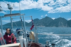
| Vicky Jackson|
| |
|
|
| |
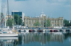
| Constitution dock in Hobart warmly welcomes those who’ve raced from Sydney across the challenging waters of Bass Strait.* * *|
| |
|
|
|
A No-Man’s-Land
The passage was a piece of cake with little wind all night, until we bore away round South West Cape and found a favorable and moderate breeze to carry us at dawn into the craggy entrance of Port Davey. Apart from a few fishermen, cruisers, and intrepid hikers, few come here. At various times, there have been unsuccessful attempts at settlement and industry. The area remains an almost treeless wilderness of granite, quartz, and button grass. Port Davey is so unfrequented that large, white areas of the chart for the entrance are apologetically marked “unsurveyed” or “inadequately surveyed.”
Bathhurst Channel and Bathhurst Harbour beyond are the inner sanctums of Port Davey. The entrances north and south of Breaksea Island are terrible places in the frequent gales. However, the island lives up to its name, giving total swell protection to the channel with its numerous coves and small, tree-covered islands. Breaksea Channel is surrounded by mountains that appear either bleak under low, gray skies or bright in sunshine, glittering with white flecks of quartz.
The best of the anchorages–at Bramble, Wombat, and Casilda coves, Claytons, and all the way up Melaleuca Inlet–offer all-round protection from the unpredictable weather. However, the mud on the bottom is often only a thin disguise for the rock underneath. We sat out our only serious gale at snug Casilda, where we could anchor with a stern line to a tree and two anchors out forward.
The social hub of Port Davey lies up Melaleuca Inlet, where the handful of inhabitants live near the airfield that brings in the national-park wardens and very occasional ecotourists. Peter and Barbara Wilson, from England, have a small tin-mining operation. Twice a year, they load several tons of ore aboard their yacht/ workboat, the brigantine Rallinga, and deliver it and a smaller quantity of smelted pure tin to Hobart. Theyre resourceful, independent, and hospitable to cruisers, who may find the hike back to the boat a challenge after a few glasses of Barbaras excellent home-brewed beer.
Having wound our way through the shallows up Melaleuca Inlet, we tied up along a staging ahead of Matthew Flinders, a former Adelaide Pilot boat. Skipper Clyde Clayton is the last survivor of the family for which Claytons is named. Now 87, Clyde crayfished around Port Davey for nearly 60 years before leaving the family home after his wifes death a few years ago. Though he now lives up the Huon River, on the east coast, he cant stay away and brings Matthew Flinders around for a few months each summer.
Before we left Port Davey, Vicky was determined to climb nearby 2,520-foot Mount Rugby. Fortunately for her, wed met another boat, Gundy Grey, with an equally keen crew of hikers. They set off on one of the few days that the mountain wasnt shrouded in low cloud while Tom played boatkeeper for both yachts and nursed a conveniently injured foot. Rewarded by the stunning view, Vicky returned exhausted and just in time to be told that there was a perfect weather window for the 90-mile passage to Macquarie Harbour. The window was so perfect that the wind faded by midnight and we motorsailed the rest of the way.
In contrast to the rocky but open approach to Port Davey, Macquarie Harbours entrance is over a sandbar, then through a rocky cleft called Hells Gate. The tide from the 20-mile-long harbor sluices in and out through this tiny opening at up to seven knots, and in heavy west-to-northwest conditions, its impossible to negotiate. As we ran the gauntlet of the ebb, we saw our first evidence of the still smoldering bush fires that had claimed thousands of acres during the previous dry summer. One house, perched on the hill above the Gates, seemed to have been spared only by divine intervention, since the whole area around it had been charred.
As we negotiated the shallow channel, we thought wed made a mistake. This was supposed to be wilderness; a World Heritage area was only 10 miles away. Yet as we struggled with the tidal whirlpools, we also had to dodge 100-foot catamaran cruise boats carrying scores of waving tourists. We soon found that we were where we were supposed to be. For a few hours each day, three cruise boats charge up and down the harbor from the port of Strahan (pronounced Strawn), at the northern end. They take their sightseers to Sarah Island and the lower reaches of the Gordon River, then disappear. Otherwise, during our 10 days in the harbor, we saw only three visiting yachts.
With its tree-clad slopes and sheltered waters, the harbor is a wonderful cruising area in miniature, with the convenience of a small town at one end for occasional replenishment. The real pearl in this oyster is hidden at the southern end, where the Gordon River empties into the harbor. Unlike almost all of Tassies other major rivers, the Gordon was only just saved from damming by a vigorous statewide protest. Now its world renowned for the beauty of its surrounding wild country and the mirrored reflections that the unspoiled countryside casts in its placid waters.
The cruise boats go only about six miles up the river, but for cruising sailors, it’s navigable for another 14 miles. Just short of this, we tied Sunstone up at Warner’s Landing and headed off in the dink, pushing upstream against the building current, our three-horsepower outboard barely getting through the smoother edges of Big Eddy and the second set of rapids. A mile farther on, we branched off to the left into the calmer, narrower reaches of the Franklin River.
Though kayakers occasionally make their way down from its headwaters, the Franklin has all the marks of forest wilderness. On each side theres a tangle of impenetrable trees and undergrowth. Its silent, apart from the occasional birdcall. A raging torrent in winter, the waters now were low, and after another mile up, we headed back in growing twilight with trepidation–which proved ungrounded–that the rapids would be harder to negotiate at speed going back down. It was strange to feel like adventurous explorers after a five-mile dinghy trip, having sailed 35,000 miles to get to it.
Back to Bass Strait
Our final stop in Tasmania was at the Kent Group–the islands of Deal, Dover, Erith, and North East–in the middle of the notoriously stormy Bass Strait. The group’s location does nothing to recommend it, though the islands do have a stark, cliffbound attraction and anchorages that provide protection from most directions. At 1,000 feet, Deal’s lighthouse is the highest in Australia and reportedly the second highest in the world, and though the island is no longer permanently inhabited, a succession of voluntary caretakers lives there. Brett, Val, and their daughter, Priya, were in the last month of their tour of duty when we visited. We walked along together, and as Priya chattered and Brett told us about the island’s history, we stopped in front of a plaque commemorating the first lighthouse keeper. Suddenly, we were transported back to a lighthouse visit earlier in our Tassie cruise.
While anchored at Mickeys Bay in DEntrecasteaux Channel, wed taken the long, dusty hike out to Cape Bruny, at the southern end of Bruny Island. Apart from making the acquaintance of a short-beaked echidna, a platypuslike mammal that lays eggs, we also found the second oldest lighthouse in Australia, built in 1836. The first lighthouse keeper there, William Baudinet, and his wife, Augusta, had 12 children, of whom no fewer than four became lighthouse keepers in their turn. Now we stood on Deal, another lonely, stormswept outpost, to find that William and Augusta and their children had been here, too. There must be something about the isolation, those long night hours, and the sound of the breakers on the cliffs.
Brits Tom and Vicky Jackson, former educators, and their 40-foot S&S; cutter, Sunstone, arrived in Kodiak, Alaska, last June, having logged 7,800 nautical miles of sailing since leaving New Zealand in March.


