Zartman- charts
It has been the longest, coldest winter Ganymede has ever seen—rightly so, since it’s our first in these northern parts, but we’re told that it being cold this long is unusual even for here. There is a list, dozens of items long, of projects that must get done before we can sail for Canada and beyond this summer, but most of those things require warmer temps and to have the winter canopy removed.
There’s been a gradual increase in temperature for the last few days, but nothing near enough to make us even think of dismantling the life-giving canopy, which has not only kept us warm and dry over the winter, but provides a gargantuan amount of extra storage space. We’ve grown accustomed to our elbow room inside, and quite enjoy having a coat and shoe closet outside, but at the same time we’re beginning to grow antsy, knowing that all these projects that must be done will require time, and our sailing date can’t be pushed back very far. Of course it’s not as though we don’t have plenty to do with the canopy up: there’s some painting that would benefit from being sheltered while it dried, there’s a lot of sewing Danielle’s trying to do at her machine, set up in the cockpit, and there’s our biggest winter project: getting together all the necessary charts for the upcoming cruise.
In the past, we simply bought our charts from Bellingham Chart Printers in Washington, who sell very convenient folios of U.S.-published charts, printed in black and white (or ‘Grayscale’ as they call it), and reduced to 2/3 size, which fits beautifully on our chart table. We used their charts all the way from California to Florida, and before that when we were sailing in Capella, and find them easy to use and affordable. But our future cruising plans take us to places that Bellingham doesn’t carry charts for—Canada and the U.K. There’s a small selection of very outdated charts on their catalog, but they seemed reluctant to sell even those, and we decided to poke around elsewhere and see what we could find.
We hadn’t poked long before we found our very own neighbors had a goodly heap of English charts bequeathed by their vessel’s former owner, and we lost no time in borrowing those and taking them to the large-format copiers at Staples. Our editor at Cruising World magazine was kind enough to let me look through their stash of charts, which filled out the collection a little more, and better yet, netted me a good few cruising guides. Another neighbor found a heap of Nova Scotia charts, which we also borrowed and copied, and if just one more person follows through on his promise of Newfoundland charts, we’ll have all the coverage we need.
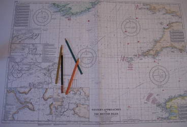
Given the cost of making color copies, and the hundreds of copies we’ve made, we did them all in black and white. Some charts, especially the older ones that were never meant to be in color, are very easy to read. The easiest are several ancient Nova Scotia harbor charts, drawn from a survey done over a hundred and fifty years ago, and having absolutely no latitude and longitude marks at the edges. So there will be no plotting GPS positions on those! But as long as the bearings are still the same, they’ll be perfect for piloting. The newer charts, which distinguish between land and sea and rocks by colors, rather than by shading, are nearly impossible to read in black and white. So one of our tasks, as winter slowly gives way to spring, is to illuminate our charts with colored pencils. Green for Ireland, a brownish-gray for England, yellow for France, and all the fathom lines in deepening shades of blue. We did this, years and years ago, to our first set of copied Caribbean charts, and found it a splendid way to get acquainted with places soon to be visited, and to put foreign-sounding names on a mental map.
Of course even with winter going so long we’re behind on that, since there’s hundreds of charts to color, and each must be meticulously done. But we’ll do the most important first, and as we cruise we can hopefully find time to color in each chart before we need it. I can only hope that by the time we’re done we’ve used them all.
We are the Zartman family: Ben & Danielle, and our three girls, Antigone, Emily and Damaris. We created this blog to chronicle our sailing adventures on Ganymede, a home-finished 31-foot gaff-rigged cutter, which has been our home since 2009, when we sailed from San Francisco, California, to the Sea of Cortez, then down along the Central American coast. Currently in Newport, Rhode Island, we plan to sail to Canada, the U.K., and beyond this summer.


