Geonav
Over the past 20 years as an electronics columnist, I’ve seen more than a few marine-electronics companies come and go. When they arrive, they usually start off with a single product and a promise to build out the rest of the line in the future. But that’s not what happened this time with the launch of Geonav (www.geonavmarine.com) into the U.S. market.
Unlike many other companies seeking to provide electronics to U.S. sailors, Geonav is no first-time startup. Rather, according to the company’s business director, Bruce Angus, Geonav was founded in 1982—in part by Giuseppe Carnevali, who also founded electronic-chart maker Navionics—to produce plotters and basic charts, but it soon became a subsidiary of Navionics so it could sell charts to its own plotter base. Geonav plotters were sold primarily in Italy, with a minor share in France and a few other small markets. “Navionics,” says Angus, “deliberately didn’t market Geonav into the major U.S. and European markets because it didn’t want to run afoul of the original-equipment manufacturers who built plotters compatible with Navionics charts in the United States”—Raymarine, Furuno, and Lowrance, to name a few. “Since then, Geonav has been relaunched in Europe as a full-line electronics manufacturer under Johnson Outdoors ownership, and the company made its debut in the U.S. market at the 2010 Fort Lauderdale boat show. This year’s Miami show was the second and biggest stage of our U.S. launch.”
And that’s where we got the opportunity to put the full line of Geonav gear to the test out on the water. The first thing you’ll notice about this series of electronics is the ultra-cool graphics on all of the displays. The resolution is like a high-definition TV, super-sharp and colorful, and I immediately wanted to start twisting knobs and pushing buttons to see what lies behind the opening screens. Which is exactly what I did offshore in 3- to 5-foot seas off of Government Cut, in Miami.
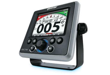
Our test boat was decked out with an entire Geonav system, starting with the G12, a 12.1-inch, daylight-readable multifunction display. (The G10, with its 10.4-inch display, is also available for smaller nav stations and helms.) Interfaced with that was its HD Ethernet radar; side-and-down-imaging sonar; GPS 50 receiver; MID 110 multi-instrument display; GSC 110 autopilot; along with all related gear, a joystick, and Automatic Identification System. The multifunction display is really the command-and-control center of a Geonav system, which—like other brands—includes a series of plug-n-play sensors like sonars and radars that can be added to the mix. That part of the Geonav story isn’t unique. There are, however, several other features that make Geonav products stand out in the busy marine-electronics marketplace.
First off, the system offers what the company refers to as “groundbreaking DualFuel Cartography.” This means the unit can display electronic charts from both Navionics and C-MAP at the same time, including the former’s highest-level Platinum+ and the latter’s 4D packages, thus giving you the best of both cartography worlds. Having spent days and days using both brands of cartography at sea, I can tell you that there are distinct advantages and disadvantages to each brand. Without going into specifics, one brand is known for showing larger buoys at a greater zoom range than the other. Why is this important? Because as a bluewater sailor, if you’re plotting a coastal cruise from, for example, Cape Hatteras to Block Island, you don’t want to have to keep zooming in, find the buoy, mark it as a waypoint, zoom out, then plot the line to the next mark—it’s easier and faster to plot a route if you can stay out at the same zoom level and enter all the waypoints in one shot. So, as this relates to DualFuel Cartography, the benefit became obvious when I tested the system’s radar-overlay capability.
To fine-tune the radar, I turned up the sea-clutter setting to eliminate the whitecaps around us from the display, and I picked up a target on the radar where there were no boats or ships that I could actually see. There was no buoy shown on brand A’s chart at that zoom level either, so one would think that it might be a small boat. But after I toggled over to brand B’s chart, there it was, a buoy marked on the chart plain as day, with the radar target very close to it, leading me to conclude that the target and buoy were one in the same. I can envision lots of scenarios—from shoreline curves to chart-notation variations—where having the ability to toggle back and forth between C-MAP and Navionics charts gives you the ultimate peace of mind, and only Geonav offers this technology at the time of this writing. In addition, some parts of the world are better charted by one of the companies or the other.
The next innovation is what Geonav calls its “exclusive BlueLogic User Interface,” which is how you, the operator, control all of the action on screen. Before we get into the specifics of this interface, I can tell you that these Geonav products are designed and manufactured in the United States, and the company has recruited some of the brightest stars in marine electronics to work on the team. Having said that, it should come as no surprise that the user interface offers just about every possible menu choice and customizable display you can imagine. And with the exception of touchscreen operation, it has just about every other type of control you’ve seen on other electronics—except they’re all here at the same time. This includes plus and minus keys for zoom ranging, two soft keys that open a variety of menus, a view key to rotate through screen displays, a rotary knob that can be turned to select and pushed to enter, a menu key, and a joystick. At any time, if you find yourself too deep into a menu and want to exit back to the home screen, just push the X key.
By far the coolest feature that I saw was what the company calls the HaloView Rotation. This is similar to what we see on today’s iPhones and iPads, where you can quickly scroll through various screen presentations, but in this case, you use the rotary knob as opposed to a touch screen. Regardless, this is a very fast and easy way to preview the screens before you enter one and start using it. It’s a big time saver.
Views are either single pane or multi-pane, and there are already some views saved in the Favorites rotation. For example, you may want to see a screen with the chart on the left, the radar on the upper right, and the sonar on the lower right. This pre-set layout is already in the HaloView for your convenience.
According to the Geonav owner’s manual, “You can add to your Favorites rotation, rename the views, and change the Favorites rotation order. Then, use the Pane Settings Manager to customize each pane. You can save up to 50 views in the Favorites rotation, and when you first power on the multifunction display, the Chart View will be the default view.”
This is where we start getting into the unbelievable customization of the Geonav displays. Between all of these controls, soft keys, and menus, you can drill down and customize just about anything you want. I see this as a real benefit to the more electronically savvy navigators, but it might be a bit daunting for a newcomer to marine electronics. This is a very sophisticated system, designed to be at the higher-end of the marine-electronics spectrum, and so even though it can do almost anything you’d like except automatically start the coffeemaker, it may be too advanced for novices. A good example is in some of the default settings I found. The system we were using was a factory demo, so I wanted to get in there and change the units from metric to the U.S. system of weights and measures. Not a big problem, and once you set that up, it’ll stay that way forever if you want it to. I also wanted to change the default from degrees true to magnetic, but I was surprised to find out that that setting couldn’t be found in the Units menu option. I’d have to find that setting somewhere else, I learned. So the bottom line here on operation is that while the system can give you a lot, you’ll have to input a lot in terms of initial setup to get it the way you’d like it. After that, you should be good to go.
Turning our attention now to performance, I found the radar and sonar to be on par with other high-end electronics on the market today.
The radar showed good clarity, the controls let you clean up a cluttered screen, and, as I mentioned, the target returns were nearly on top of buoys, shorelines, and other fixed marks. On the sonar side, we ran out to around 70 feet of water and the unit never lost the bottom. The fishfinder display was accurate enough to actually show us the contours of a wreck we located on the chart, and it was sensitive enough to show us bobbing up and down on the waves.
We then spent some time checking out the MID 110 multi-instrument display, which is a huge nav station space saver for sailors. Specifically, we tested the Sailing display that was connected to an Airmar PB150 ultrasonic weather station. No need for cups and vanes here; this all-in-one sensor has no moving parts and detects true wind, apparent wind, air temperature, barometric pressure, GPS data, and even wind chill all in one compact unit the size of a medium coffee cup. It was very helpful to see the true- and apparent-wind information clearly shown—graphically, numerically, and in color—right on the MID 110. The MID 110 works with data in both NMEA 0183 and 2000 formats, as will the advanced GIS series of multifunction displays that Geonav will introduce in the fall.
And finally, we put the autopilot through its paces; it was, of course, integrated with the main multifunction display. I had our captain plot out a multi-waypoint route to determine how well the autopilot held to the plotted course line and what it did when it came time to turn on to a new leg of the route. The autopilot did an exceptional job of holding us on the plotted line, even in a sloppy, beam-to sea that was constantly trying to push us toward a lee shore. And when the time came, the autopilot dutifully made a 90-degree turn to port without prompting, which for some skippers could be an issue. Once you near a turning waypoint, the unit displays a very short text message on the screen, then goes ahead and initiates the turn with no further input from the captain. This is in sharp contrast to some other autopilots I’ve used, where you must confirm the turn before the autopilot will execute. While the company says it argued internally for hours over this decision to automatically make the turn rather than requiring confirmation, it pointed out that the captain did plot the course, meaning that he or she would want to make the turn at the appropriate time. My only issue with this is what happens if there’s another boat nearby and the turn will put you right on it? Fortunately, at sailing speeds there’s usually plenty of time to make a course correction if it’s needed, and that can easily be done with the push of a single button to disengage the autopilot and take over manual control. Or you can simply use the joystick to maneuver around the other boat or any other obstruction that’s in your way.
Overall, it’s refreshing to see a “newcomer” to marine electronics that actually has 25 years of manufacturing under its keel. And given the fact that the new Geonav is part of the giant Johnson Outdoors organization—the makers of Humminbird fishfinders, Scubapro dive gear, and more—you know the company is going to be here for a long time to come. So if you’re the type of navigator who likes to roll up your sleeves and really dive into the menus, the complete navigation system from Geonav has the ability to make you the coolest captain on the dock.
Captain Chris Kelly is a veteran navigator who writes frequently about marine electronics.