Raymarine’s LightHouse Charts help with GPS navigation. They’re created from official hydrographic chart sources with multiple color palettes and customizable chart symbol controls. The Premium version also allows access to regular chart updates, an expanded points of interest library, and enhanced satellite imagery.
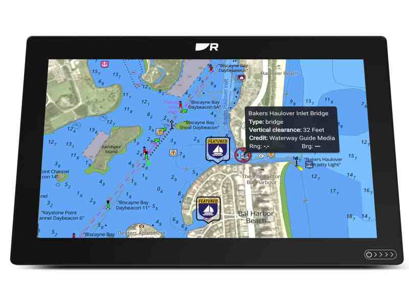
Now, that Premium version of LightHouse Charts also includes data from Waterway Guide, which is another source of information that many yacht owners trust. These guides—available for locations from the Great Lakes to the Caribbean—have been produced since 1947, and they include information about things like marinas, anchorages and fuel stops.
Boy, have we boaters come a long way since paper charts and slide rules. Press a button today, and the world is your oyster as a cruising sailor.
According to Raymarine, “a wealth of digital information” from Waterway Guide is now available to LightHouse Chart Premium users. This information includes databases of marinas, anchorages and service facilities; pinpointed locations of bridges and locks; and navigation alerts about safety information and potential hazards.
LightHouse Premium data also includes the latest chart updates, fishing local hotspots and high-resolution satellite imagery for shorelines, shallows and more.
Waterway Guide is not the only partner that Raymarine works with to build useful information into its LightHouse Charts. Additional partners include Mapbox, which delivers global satellite and aerial imagery along with detailed land-based street and points of interest data.
Marinas.com is also a partner of LightHouse Charts. The Marinas.com data includes more than 75,000 local marinas, anchorages and marine locations.
Yet another partner of LightHouse Charts is Reeds Nautical Almanac, whose data covers the Atlantic coastal waters around the whole of the United Kingdom, Ireland, Channel Islands and the entire European coastline from the tip of Denmark to Gibraltar, Northern Morocco and the Azores.
How can existing LightHouse Chart Premium users add the Waterway Guide data? Update the subscription via download from chartstore.raymarine.com
Where to find more information: click over to raymarine.com


