It was as if cruising dreams came true. We would swing the boat behind an island into a smooth creek. The forest between the ocean and the anchorage muted the sound of the breakers to a distant sighing. In the morning, a short row brought the dinghy ashore. It took a walk around the end of the island to reach the Atlantic shore, foaming wavelets on one side and dunes on the other stretching for maybe 10 miles with only bird footprints on the sand. Add sea turtle tracks during nesting seasons.
It might sound like a dream, but at least 10 major barrier islands fit this description — most of them uninhabited and protected from development as state or national wilderness areas — on the Atlantic coast of Georgia. After spending the winter months in Brunswick Landing Marina, the most cruiser-friendly of the area, we took off southward and sailed almost all the way to the Florida border. My wife, Nancy, and I then turned north to enjoy a slow cruise before our May departure to the high latitudes of Canada and Greenland.
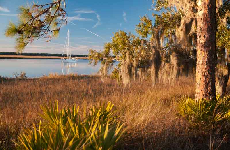
About halfway to Cumberland Island, our VHF screamed with tornado warnings. Behind us, the arch of the Sidney Lanier Bridge over the Brunswick River stood silver against the black-blue sky. Our Mason 44, Frances B, plowed through the mud-choked channel along the west shore of Jekyll Island. We hoped the almost-high tide would keep our 7-foot-deep keel off the bottom. April rains had turned the live oaks, cedars and palmettos on Millionaires’ Row — the island’s historic district — bright green. Nineteenth- and 20th-century financial heavy hitters of America — including the Macys, Astors, Goodyears and Vanderbilts — created what was once a very exclusive club on the island’s west shore. Grand steam yachts arrived in the winters, among them Pulitzer’s Liberty and J.P. Morgan’s Corsair. But the good times ended with World War II. In the 1950s, the state of Georgia bought the island and brought in convicts to build a causeway from the mainland, and there is now a small marina next to the bridge. The disturbance of the natural water flow from the bridge has silted Jekyll Creek into a mud bath, only about 3 feet deep at low tide in some places. The Jekyll Club and some of the humongous “cottages” of the wealthy remain. Birds love the place: We saw avocets swing their upturned beaks through mud, and greater scaups — seagoing ducks — came in flocks when the Atlantic boiled up in a gale. We took the deepwater trench off Jekyll’s southern point and came within spitting distance of a thick flock of black skimmers, powerful flyers that stand on ludicrously short legs; they, with a few pairs of oystercatchers and many terns, tolerated our gawking so close.
St. Andrew Sound, farther out and open wide to the ocean, lay smooth despite a fresh south breeze. Thick clouds to the southwest planted some doubt as to whether we’d make it to a safe anchorage in the Brickhill River on Cumberland Island before the weather hit. But our luck held. We dropped anchor in all-around protection with solid forests from north to south on the eastern shore and marshes cutting off any possible chop from the west. The night turned out to be calm, and insects whirred around the anchor light. We hung it low, where it would be more visible to river traffic than the usual light high on the masthead.
At dawn the sky opened with pouring rain, and explosions of lightning chased me below to put our computers in the oven, a makeshift Faraday cage to protect them from the high currents of a possible lightning strike. A wedge of blue, clear as a baby’s eyes, promised a change soon.
When the sun came out, the marshes and forests shone. On the shore across the river, a flock of white pelicans settled. These birds spend cold months in Georgia and Florida, and were almost double the size of the brown pelicans we were used to seeing. After powering a few miles south on the Brickhill River, we anchored Frances B close to tall roosting trees. In the evening, egrets fluffed their white wings like medieval ladies waving handkerchiefs to their knights. Long-nosed wood storks settled down for the night on stick legs, while closer to the water, night herons prepared for feeding. Between the oaks ashore, the white walls of Plum Orchard Mansion blinked.
I have to admit, the wealthy of the Gilded Age had a talent for finding the best island retreats. Ninety percent of Cumberland Island, the longest of Georgia’s barrier islands, at 20 miles, was once owned by Thomas M. Carnegie’s family. One of the family’s three large mansions, Greyfield, is now a posh hotel. Today, most of the island is encompassed by the Cumberland Island National Seashore, a status declared by President Nixon in 1972 that prevents further development.
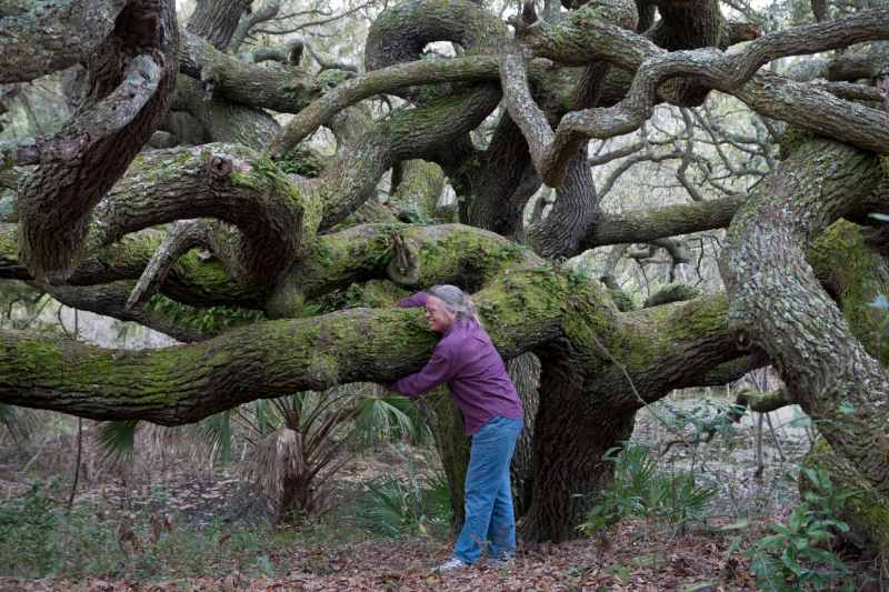
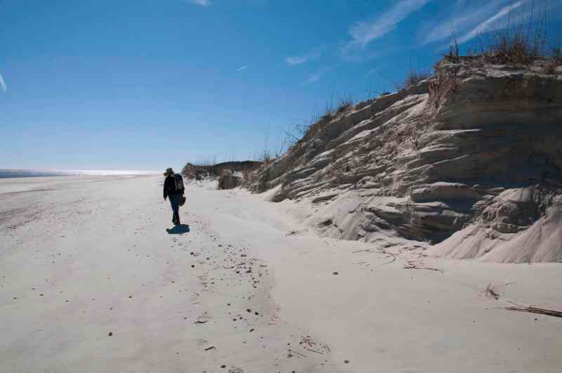
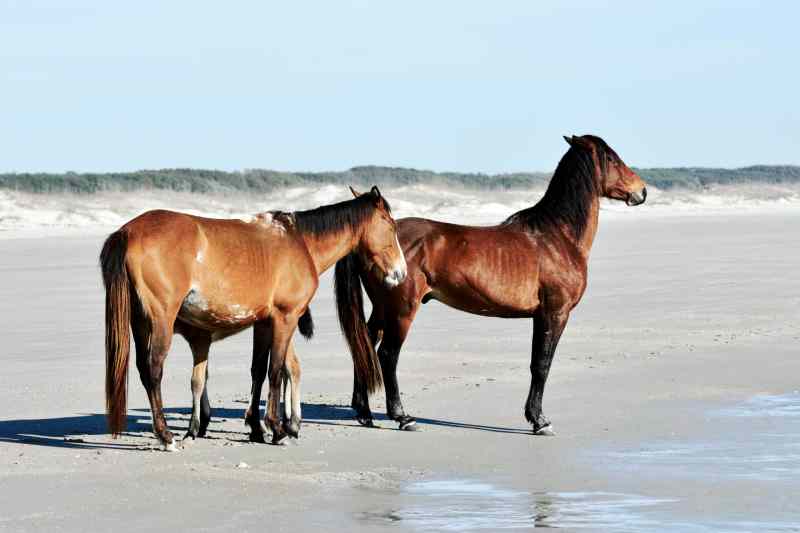
Cumberland Island’s dunes, some 40 feet high, are hammered by strong onshore winds and drift continuously inland. Caught in this dynamic environment, the native live oaks form enchanting forests. Their twisting limbs snake low for 40 or more feet, longer than the heights of the parent trees; among them we felt surrounded by animate creatures. We followed trails through a network of spidery oak branches, shaded by their leafy canopy. On the ocean side, we stepped upon the widest beach we had seen yet. At the wave wash, a family of feral horses stood — male, female and an awkward colt on stiff stick legs — probably enjoying the cool, insect-free air as much as we were on that early morning.
When the time came to leave our exploration of Cumberland Island and start northward, we yanked the dinghy on board with a spinnaker halyard and sailed offshore, re-entering the Intracoastal Waterway at St. Simons Sound. More than 13,000 people live on St. Simons Island. However, even when searching for remote wilderness, you’d be wrong to dismiss visiting here. Sure, while sailing up the Frederica River along the western shore of the island we saw several tree-framed mansions. To the west, though, miles of marshes and creeks breathed with the tides, wild and intact. About halfway up the river, Frances B slid, uncontested, by the guns of Fort Frederica, General Oglethorpe’s 1742 bastion of English presence against the Spanish. A Spanish armada of 36 ships landed a few thousand men against small numbers of the English and Indian allies. After the English prevailed, a tiny town grew around the fort, which is toy-size by today’s standards.
The Hampton River cuts east along the north shore of St. Simons Island. Marshes spread out like marine prairies along the river’s north banks, home to birds, otters, minks and dolphins. Swinging between beacons we passed a marina, some housing and a densely wooded uninhabited point of the island. We plunged into Pine Creek, an oxbow off the Hampton River, and saw three glossy ibis winging overhead. Snowy and reddish egrets punctured the mud banks for food, and an extended family of mergansers paddled away. A wood stork, black headed with an enormous wingspan, hovered over a deeper pool on the almost-flooded upland. Exploring Pine Island, a type of islet locally known as a “hammock,” we pushed and dragged ourselves through a thick growth of fan-shaped, sharp-ended scrub palmettos, twisted oaks and pines. The edges of crumbling oyster shells stuck out from humps of dry soil — ancient middens left by foraging Guale tribes. The din of cackling marsh hens, or clapper rails, resounded in the spartina marshes as the sun went down. This wild place that had forgotten the hand of man made us happy.
Swinging north from the Hampton River, Frances B began furrowing through swirls of thick brown mud from the undammed Altamaha River, once a waterway for rafts of timber logged in the flooded forests and river banks. The muddy waters continued into Doboy Sound, whose tides race by the south end of Sapelo Island, which is populated by some 40 descendants of Gullah-Geechee plantation slaves. There is also a marine wetlands research station and tobacco magnate R.J.
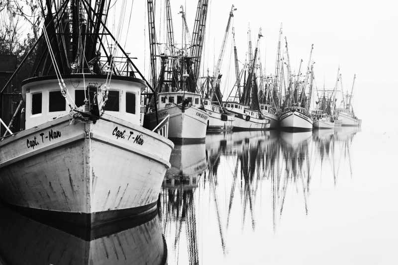
Reynolds’ old mansion-turned-guesthouse. Thousands of migrating birds stop in the tall grasses near Sapelo Lighthouse. Hunters are allowed to come on prescribed dates to shoot deer and feral hogs. Their sometimes overeager reputation precedes them, and the permanent residents in Hog Hammock spray-paint “COW” on their animals. During the 19th-century timber boom, dozens of ships anchored in Doboy Sound waiting for a place in Darien, a small town upriver. In those days, Darien could load 20 windjammers a day to carry Georgia’s long leaf pine and cedar worldwide. Now Darien slumbers, its fleet of shrimp trawlers small by comparison.
We turned Frances B east in Sapelo Sound and, on the rising tide, slipped over the bar into Blackbeard Creek, which separates Blackbeard Island from Sapelo Island. Anchored in a deeper pool, the boat was virtually invisible with thick forest to the east and west, and more high trees on Sapelo Island. We had found the perfect hideaway for a pirate. Three centuries ago, before colonial loggers cut the old forests and the mud began bleeding toward the sea, this creek would have been deep enough for large ships. With the exception of the persisting name, there is no firm evidence that the badass Blackbeard, also known as Edward Thatch or Teach, set up a base here. The name Blackbeard Island first appeared on a survey map in 1760, four decades after Thatch’s severed head swung from the bowsprit of a British navy ship. In 1940, the island became a federal wildlife refuge. Our reconnaissance dinghy ride ended at a floating dock covered with otter droppings, tangible proof of the thriving wildlife. The trails ashore lead into the shadows of a dense forest, the branches curtained with witches’ tresses of Spanish moss. The moss, an epiphyte common in the American South, is sensitive to pollution and attested to the clean air. Now and then a deer scampered away, its white tail flagging among trees. We tracked an armadillo nosing through layers of leaves when we heard noisy rustling off the side of the trail. A silent owl with feathers the color of the leafy backdrop followed our passage with its round, yellow eyes. The trail spilled onto the beach in a tangle of fallen oaks and palmettos. Clusters of small oysters covered the roots at the water’s edge. Not a trace remained of the quarantine wharf where ships bound to Savannah for rice or to Darien for timber once had to stop — the station was closed in 1909 when the yellow-fever vaccination proved effective. On our visit, only bird tracks and scattered seashells etched the 5 sandy miles of the Atlantic beach.
St. Catherines Island, the next one to the north, is unusual. Its owner, a foundation that breeds endangered animals, including ring-tailed lemurs, has put the island off-limits to casual private visitors (per Georgia law, the beaches to the high-tide line are still free for roaming). The St. Catherines Island Foundation’s research station stands on the grounds of what was once a Guale Indian village, later a Spanish monks’ mission and finally the plantation of Mary Musgrove, a legendary figure in Georgia’s early history. White Georgian plantation owners lost the island to freed slaves at the end of the Civil War. One of them, Tunis Campbell, took over as a leader and even formed an army of 250 men. After all this and even after a hurricane washed over the island completely in 1893, St. Catherines looks primordially wild today.
We anchored Frances B in Walburg Creek along the west shore, and spring low tides bared a fantastic stretch of sand banks in St. Catherines Sound. We splashed through ankle-deep water and spent a couple of hours studying the shells of whelks, cockles and angel wings. We chased painted olives — mollusks — as they escaped head-first under the wet sand. It felt thrilling to stand in the sea a mile away from the shore of dead trees, branches and roots undermined by tides, contorted and twisted as if in agony.
The shoals of St. Catherines (and other islands) bring in bizarre horseshoe crabs to mate. About the size of a wash bowl, equipped with nine “eyes,” they have been around for half a billion years, predating dinosaurs. Their blood is tinged blue by a high copper content and contains mobile cells that destroy pathogens. Specialized labs are known to gather horseshoes, suck their blood and then return the animals to the sea; the mortality hovers between 15 and 30 percent. Back on St. Catherines beach, the wash of spent waves often rolled the horseshoes upside down. In order to flip themselves back up, their long tails lashed the sand to find purchase; their 10 legs paddled the air pathetically. We couldn’t bear their trauma and so spent hours returning the ancients to their home.
In the ICW, our 7-foot draft forced us to time our passages. The tidal ranges in Georgia vary between 6 and 11 feet, so we had to deal with shallows on the rising tides and anchor before the tide ran too low. We used the dinghy to explore the veinwork of tight streams, often sending aloft flocks of migratory shorebirds that gathered on sand and oyster bars. We followed Cane Patch Creek on the west side of Ossabaw Island past treed islets named Queen Bess and Queen Mary. We weren’t sure of the namesakes, but thought Mary could have been the aforementioned Mary Musgrove, so-called Queen of the Creek nation and a tribal diplomat when, in 1733, Oglethorpe founded Savannah and Georgia. Buckhead Creek just around the corner led us to a shore where vines had taken a tight grip on old slave houses built of “tabby,” the mixture of oyster shells and lime common in Colonial times. Nearby, some wooden structures marked an extinct 1970s hippie commune. The midday sunshine brought out an alligator, the sole warden of the place.
The Bradley River on the northeast coast of Ossabaw Island, where we anchored Frances B next, undercuts a shore of high sand bluffs and then flows south into the marshes. The high dunes of Bradley Point lead to a blazing-white Atlantic beach roughly 8 miles long. Nesting turtles — loggerheads, leatherbacks, greens and lately even a few olive ridleys — love it. Their nests are threatened by scavengers, such as raccoons and feral pigs, which are descended from farm animals imported by various previous owners of the island. Now that the island is a Heritage Preserve under the Georgia Department of Natural Resources, the feral pigs are culled annually, and the nests have better chances of survival. Also, volunteers guard the nests between May and September.
A forecast for strong northerly winds encouraged our departure before the swell could begin to break over the shoals scattered in Ossabaw Sound. The jagged line of high pines on Wassaw Island stood well-defined 4 miles away to the north, but a patchwork of shallow banks stood in the way. We navigated 10 cautious miles on a calm sea and rising tide to reach the well-protected Wassaw Creek. At its mouth we slowed down to watch four dolphins, the creek so thickly muddy that only the wakes of their dorsal fins let us follow their course. We passed so close that, when their heads appeared to breathe, we could see their eyes tracking us. The feeding was good — shoals of fish whipped the surface in a frenzy. At some point, a school of mullet shot out of the water onto a mud bank and the dolphins slid up in pursuit, then wiggled back into the creek.
We used a floating dock by the warden station of Wassaw Island National Wilderness Refuge as a base for treks ashore. Wassaw Island is really a series of parallel dunes covered with pines and live oaks that somehow eke nourishment from the sandy soil. At the back of the Atlantic beach, though, the Spanish bayonet (yucca) grows unusually tall, the size of small trees. The sea oats grow thick and happy on this shore, free from predation by the wild horses, wild donkeys and deer found on some other islands.
In May, the weather began warming up uncomfortably, at least to us who now thought of cooling off far north in the iceberg alleys off Labrador and Greenland. We suddenly realized that after leaving Georgia’s wild barrier islands, we wouldn’t experience real wilderness again until a landfall in Labrador — over 2,000 miles away.
• • •
Tom and Nancy Zydler, authors of the guide The Georgia Coast, Waterways and Islands, sailed north to spend the summer on the coasts of Labrador and Greenland after cruising Georgia. In 2018, they plan to cruise to seabird colonies and rookeries on the north shore of the Gulf of St. Lawrence and Newfoundland.


