Jerry Immel, a longtime resident of St. Thomas, U.S. Virgin Islands, will never forget last September 15. As Hurricane Marilyn slammed into the island with sustained winds of 115 mph late that Friday night, he stood on the bridge of his 96-foot tug in the midst of the worst storm he had witnessed in his 30 years as a licensed captain.
Before 10 p.m., Immels anemometer pegged its top reading of 100 knots and stayed there — until it blew away. Suddenly, the blackness disappeared and a ghostly white glow lit the harbor. It wasnt lightning or St. Elmos Fire. What Immel had witnessed was a rare phenomenon, one meteorologists theorize was caused by moonlight shining at an angle through the hurricanes eye some distance away.
Despite a massive amount of study, hurricanes still are not completely understood. Last years Atlantic hurricane season was the most active since 1933, when 12 tropical storms and nine hurricanes formed. In 1995, a total of 11 hurricanes and eight tropical storms lashed the Caribbean and Atlantic, setting a new record for the total number of full-fledged hurricanes in one season. Yet in the Eastern Pacific, hurricane activity was well below normal. There were seven hurricanes and three tropical storms — six named storms short of the annual average of 16 in the Pacific. Why did so many Atlantic hurricanes form last year? Why were there so few in the Pacific?
The nations leading hurricane expert, Dr. William Gray of Colorado State University, whose record of hurricane prediction is unsurpassed in the last decade, had at press time in mid-July forecast an “average” hurricane season for 1996, predicting 10 tropical storms, six of which were expected to become hurricanes. A normal Atlantic season sees an average of nine named storms, either tropical or hurricane. A normal Pacific season breeds 16 storms.
What were the causes of last years Atlantic storm bloom? Why did Dr. Gray and other meteorologists predict much less action this year? Lets start with the basics.
Hurricanes and tropical storms form under precise sets of conditions. In order for such storms to form, the sea surface temperature (down to about 200 feet) must be 80 degrees or above. Heat with high moisture in the lower atmosphere and an upper-level high-pressure system must be present. Prevailing winds outside the storm must blow in the same direction as the storm itself.
A cyclonic disturbance requires another ingredient: rotation. Beyond 250 to 300 miles on either side of the equator, the air flowing upward into a fledgling tropical storm with its low-pressure center will begin to spin, due to deflection from the Coriolis effect caused by the Earths rotation. In the Northern Hemisphere, the motion is counterclockwise; in the Southern Hemisphere, clockwise. But regardless of the direction, when the circular motion starts, its a cause for concern.
As the storm develops from a depression, the low induces warm air at the seas surface to rise, forming clouds and squalls, releasing heat and creating a low-pressure center at sea level. Air from outside the center starts to flow inward, then upward, at increasingly higher speeds.
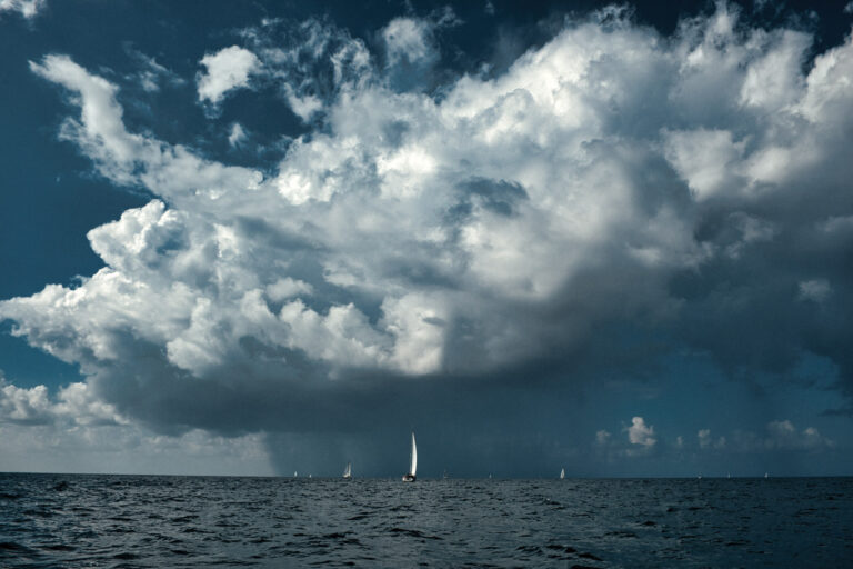
The rising air further reduces the pressure at the center. The storm starts to spin, the inward flow of air increases and flows upward even faster, and an eye forms with cloud walls that can reach 40,000 feet to the base of the stratosphere; calm air from those great heights descends into the eye.
No other storm packs a punch as powerful as, in some cases, 500,000 atomic bombs on the order of those dropped on Nagasaki in World War II. Fortunately, even when conditions are perfect for the formation of a cyclone and when a system begins to “live,” only 10 percent actually develop into dangerous blows. When a hurricane hits land, it loses heat and moisture and weakens. This is also true when a tropical cyclone travels over areas of cold water.
Back to the question, why was 1995 such a bad year? Statistically, the answer is straightforward: There were more depressions than usual from which hurricanes could form. Also, sea surface temperatures in the Caribbean and Atlantic were well above normal. Climatic anomalies also had a bearing on last years busy season. In West Africas Sahel, a semidesert on the Saharas southern fringe and the site of persistent droughts for most of the last 20 years, above-average rainfall fell in 1995. This is important, because many of the worst cyclonic storms are born on “easterly waves” originating in this region or in the Gulf of Guinea to the south. These are upper-level low-pressure troughs that travel westward on the surface and combine with the other ingredients needed to breed a tropical storm. The warm rains give strength to easterly waves.
Another key factor last year was the waning of El Niño, a periodic, abnormally warm sea surface current, and the waxing of La Niña, a periodic, abnormally cold sea surface current, both in the Eastern Pacific. El Niño, brought about by a change in prevailing winds on the Pacific side of South America, was originally identified around Christmastime (hence its name, which means “the boy child”); however, every few years a warmer than normal El Niño supplants the cold and weakened Humboldt Current. An abnormally strong El Niño can raise sea surface temperatures by as much as nine degrees. A strong El Niño also lowers the pressure in the Eastern Pacific. Strong El Niño periods also reduce African rainfall and create upper-level winds traveling from west to east that shear the easterly waves headed the other way. None of this makes a tropical storm happy; fewer storms form in stronger El Niño years.
La Niña (“the girl child”) exerts the opposite effect: Cold water returns to the Eastern Pacific, the shearing winds cease and rainfall in West Africa increases. This produces conditions favorable for tropical storm development. At such times, Atlantic tropical storms and hurricanes breed profusely and travel westward from Africa as they did last year.
So far in 1996, African rainfall has dropped back to normal, reducing fuel for the easterly waves. La Niña hasnt strengthened; it may even weaken or disappear altogether.
Another factor that likely will mitigate hurricane development in the Atlantic this year is something called the quasi-biennial oscillation, a shift in upper-level winds, which will not favor a spate of storms like last years.
Hurricanes, while often capricious, stick to fairly predictable patterns dictated by the season. In June, a time of fewer storms, most develop in the Gulf of Mexico and western Caribbean. These storms often target the southeastern United States.
In August and September, the height of the season, formation activity extends from the Gulf of Mexico to Africa. In these peak months, storms can strike anywhere from Mexico to Maine. Toward the end of the season the action returns to the Caribbean.
Monthly Pacific hurricane activity coincides with that of the Atlantic. The danger area ranges from Central America to Mexico and west to the Hawaiian Islands. Most Pacific storms move in a northwesterly direction and die in cooler waters. Occasionally, they recurve to the northeast and affect Mexico and Southern California.
Any passage maker that is inevitably and unwisely caught out at sea in or near a hurricane should understand “translational winds.” If a storm is heading due north in the Northern Hemisphere at a typical 15- to 20-knot speed, for example, the forward speed on the northeast and easterly side of the storm will combine with the sustained winds spinning in a counterclockwise motion.
A boat caught on the east side of the eye of the hypothetical storm with average sustained winds of 75 knots will find itself faced with southerly winds at speeds equaling the storms sustained wind speed, plus the speed of its forward motion, or in this case, 90 to 95 knots, more if the forward motion is faster. (The great New England hurricane of 1938 traveled forward at astounding speeds of up to 70 mph!)
The closer to the eye one gets, the higher the winds will be, because they accelerate in a manner similar to water running down a drainpipe. In addition, swirls of wind near the eye wall can reach speeds estimated to be in excess of 200 knots. These are not tornadoes (which sometimes do form in hurricanes) but awesome cells within the hurricanes structure.
The unlucky cruising boat facing a storm has a few options. The rule of thumb is to determine the boats position relative to the forward track of the eye, then set a course at right angles away from the deadly center. This sounds fine in theory. But taking another look at the hypothetical storm it becomes clear that a boat caught on the edge of the southeasterly quadrant would have to turn eastward to establish a right-angle course. That would mean dealing with wind and seas dead off the starboard beam — not wise. Yet running downwind with the storm would gradually find the boat sucked in toward the danger zone. One more problem of major concern is that storms dont often steer a straight course. Upper-level wind flows, determined by the presence of high- or low-pressure systems, move hurricanes one way or the other. A major high or low in the storms path will block or “steer” the storm, but highs and lows generally are themselves in motion, accounting for the often erratic tracks of hurricanes.
Hurricanes are among the worlds deadliest storms. Although climatic anomalies that caused the intense 1995 season in the Atlantic have largely gone, even a “normal” year can spell trouble for anyone unfortunate enough to be in a hurricanes path. During the busiest month for hurricane development on both coasts, keep a weather eye out and be prepared to batten down the hatches.
————————————————————————
David Shaw recently completed a circumnavigation of the major waterways in the Northeast aboard his 24-foot Bristol. He is the author of A Cheapskate’s Guide To Weddings And Honeymoons (Carol Publishing, New York, NY, 1996) and articles in the marine and mainstream press.