It’s appropriate for reflection on sailors discussing the weather to start with a bar joke.
An ol’ salt swaggers into a bar.
He has a ship’s wheel stuffed into the front of his trousers.
The bartender says, “Hey, you’ve got a ship’s wheel in your trousers!”
The ol’ salt says, “Aye, mate, and it’s driving me nuts!”
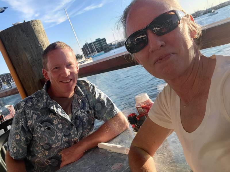
Two sailors did saunter into a bar, taking stools not far from where Jamie and I recently tucked into our lunch in Newport, Rhode Island. We were on break from teaching at the Confident Cruiser Seminar Series at the Newport International Boat Show, refueling ourselves for the afternoon, and…well, we were inadvertently eavesdropping, to be honest.
The sailors, so marked by the faded-pink Block Island Race Week cap and duct-taped Sperrys, leaned on the bar to trade war stories, somewhat loudly. We heard about being tossed around in storms at sea, of plowing a furrow down the ditch that is the ICW. There may have been mention of pirates, but a weather update about Hurricane Lee was broadcast on the TV behind them. The sailors scoffed: “Ha! So much hype, but we had a bigger windstorm a couple of weeks ago. These weather presenters, they have one job but can’t seem to figure it out.”
It’s fair enough to say that the media hype leading up to Lee was, well, unsurprisingly full of media hype. But at some point not long before this bar-leaning narrative, it was possible Newport would get whacked by the storm. Thankfully, what might have been a boat-show-ending event shifted farther east, so Newport had a little rain and wind.
Q: How do hurricanes see?
A: With one eye!
Were these sailors right to blame the forecaster? It’s an easy chuckle, as critic in hindsight. And naive or at least overly simplistic. It’s easy to take weather forecasts at face value when the immediate safety doesn’t depend on it. Sailors on the water, with capacity to travel at only 6 or 7 knots to get out of harm’s way, by necessity must be more serious weather followers and students of weather. Lee’s traverse up the East Coast was a long process. If you were in the possible path, there was much time to move to a safer location and prepare.
How long was Lee tracked? Take this excerpt from an Atlantic storm-season newsletter:
“We first started talking about Lee as it was about to become Invest 95L back in the closing days of August while Idalia was readying to impact Florida. When we say hurricane season is a marathon, not a sprint, this is what we mean.”
They’re talking about three weeks of tracking. Three. Weeks. (From The Eyewall’s “Au Lee-voir” email from September 17th.)
A piece of rope walks into a bar. The bartender says: “We don’t serve your kind.”
The rope goes outside, bends around into a pretzel, pulls a few strands, then walks back in.
The bartender says, “Weren’t you just in here?”
The rope replies, “Nope, I’m a frayed knot.”
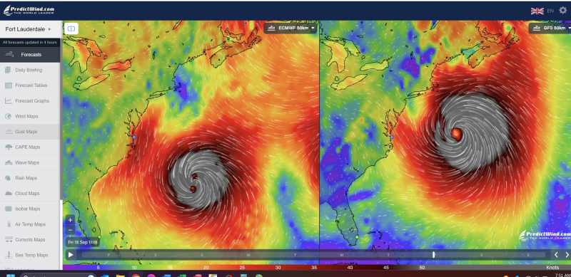
Looking back, the early forecasts for Lee turned out to be remarkably close to the actual path toward New England more than a week later. Before then, when the system was barreling toward the Bahamas and Florida, both of which with more than enough hurricane history, forecasters correctly predicted that Lee would turn north before impacting them. GFS ensemble shook out as more accurate (compared with ECMWF) on long-term accuracy of the track and timing for landfall, although both were quite similar. On the morning of September 8, Jamie posted this to our coaching client group:
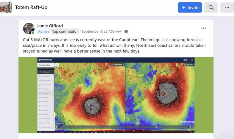
Jamie commented with this post of the models: Cat 5 MAJOR Hurricane Lee is currently east of the Caribbean. The image is showing forecast size/place in 7 days. It is too early to tell what action, if any, North East coast sailors should take—stay tuned as we’ll have a better sense in the next few days.” Notes below reference changing status of the Bermuda high/low pressure systems crossing North America, and another named storm (Margot) farther east of Lee complicates forecasting but that sailors north of Cape Hatteras need to pay attention.
Models aren’t perfectly accurate with hurricanes; they can always surprise us (like Hurricane Ian did last year, with a last-minute gyration that landed it over Fort Meyers instead Tampa/St. Pete). But the variability is consistently less. The accuracy is there in broad strokes enough to enable preparation; enough that we—the greater we, of boaters in a storm-affected region—can make good choices. About whether to move out of the way, or to haul out, or to prepare a boat as needed when you have nine, eight, seven days of lead time.
Lee’s path had two main drivers: the stationary Bermuda high, and a low-pressure system over Canada and moving west to east. The high kept Lee from bending north sooner, but once past it, the expected dogleg north happened. Then the path northward could’ve been a direct hit in Newport if the low moved faster and passed ahead of Lee. Or Lee could be steered east and away from land if the low was slower-moving. These both were predicted as possible outcomes, and the latter outcome happened, sparing eastern New England.
Q: Why do Swedish warships have bar codes on the side of their vessels?
A: So that when the ships come back into port, they can Scandinavian!
Back to our salties at the bar. At one point, it appeared that Newport could be a direct hit for the storm. Those older nightly news segments are probably what our two sailors were reliving over wings and fries because subsequent updates made this progressively less likely. The irony of sportscasters arguing over the stats and probabilities of the Saturday college game now playing on that TV behind the bar was not lost on us. Playing armchair quarterback, er, weatherman is common enough among sailors, as are weather war stories painted in colorful hues. It can be fun to indulge in storytelling. It is also astonishing how well weather is forecast today compared with five, 10, 15 or more years ago. It does require paying attention.
Join Us in the Chesapeake Bay area! Jamie and I are excited to be heading to the U.S. East Coast very soon for the 2024 Annapolis Sailboat Show and Cruisers University. We’ll be teaching daily at Cruisers U, from masterclasses and all-day courses to shorter seminars that help people go happily, safely cruising. See annapolisboatshows.com for details.


