Advertisement

Photos: Tonga’s New Island

Last year, a volcanic eruption in the Pacific changed the geography of Tonga and gave birth to a brand new island.
tonga island
The island, about 65 kilometres south-west of the main island of Tongatapu and the nation’s capital, Nuku’alofa, started forming in January after a volcano began erupting. GP Orbassano
tonga island
Hotel owner GP Orbassano, together with a friend and his son, arrived at one of the island’s three beaches on to explore the newly formed island. GP Orbassano
tonga island
The group climb to the highest point of the island’s crater, believed to be approximately 250 metres high. The terrain was rough and GP Orbassano
tonga island
Tonga’s lands and natural resources ministry has examined the island and stated that the newly formed landmass is around 800m wide and 1.3km long. GP Orbassano

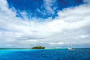
Last year, a newly awakened volcano off an uninhabited Tongan island was viewed up close for the first time. Volcanologists stated the eruption created a substantial new island off the coast of Tonga’s main island.

Tonga’s lands and natural resources ministry said experts took a boat trip to view the eruption on Thursday and confirmed it had transformed the local landscape.

“The new island is more than one kilometre wide, two kilometres long and about 100 metres high,” it said in a statement.

Advertisement

The volcano, about 65 kilometres south-west of the main island of Tongatapu and the nation’s capital, Nuku’alofa, rumbled to life on December 20, 2014 and was explored in March of 2015 for the first time after the eruption.

View more photos of the island on the ABC website here, and read the news story of the volcanic eruption here.

Advertisement
Advertisement