I’m walking down the street with a roll of new navigation charts under my arm, and it makes me smile like a drunken fool. The tight, heavy roll gives off the sour scent of new paper, telling me that I’ll soon be smelling the salty air of the sea.
I want to shout, sing, crow out this welling of joy. I want to call out to the woman with the kid hanging off one arm and a shopping bag on the other: “Hey! I’m going off to sea. Look at my new charts! Yes, I’m going sailing somewhere new!”
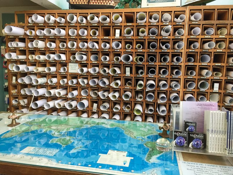
The thrill began as soon as I stepped into the map seller’s shop. The fact that I stepped through that door meant I was a sailor because no one else does business there. I told him my plans, the region of the world I wanted to see in paper and ink. Out came the catalogs, and we compared scale and coverage for the waters I’d planned to sail. I jotted down the numbers of the charts I wanted, and he went to the storeroom to retrieve my order. I browsed the bookshelves filled with almanacs and pilot guides, and admired brass instruments measuring time, humidity, and pressure and space—and I waited for my treasures to appear.
I had second thoughts when the map seller jotted up the total—Holy! I could buy new running rigging for that! Heavyweight, 50 percent cotton nautical-chart paper isn’t cheap, with each sheet big enough to paper your bulkhead. But the ink doesn’t run when the sea finds its way through an open hatch to douse the navigation station. Paper charts are so expensive that I’ve been forced to sell mine after a long voyage to pay for my flight home.
Then the map seller updated my charts, accounting for all the changes that had taken place in the physical sea while this chart lay waiting for me. With a fine-point violet pen, he noted changes in depths, buoys that had moved, and coordinates that might be off by a second or two. If there had been land reclaimed or new sea walls built, he would have glued an entire patch onto the chart, bringing it up to date. Then he rolled them tightly and wrapped them in protective paper, and finally I felt their precious weight tucked under my arm.
I bought a chart that shows an entire sea, its ratio 1-to-3,500,000, which means I’m going on a long voyage. Long enough for the weather to change, the waves to turn against me, and the sea to show its rage. We’ll lose sight of land for days and nights, and maybe even a week, just to get across this one chart. The harbor charts, 1-to-10,000, show me the rocks that the locals know by heart, the sandbanks and the curve of the jetty wall. These charts mean I’ll arrive in unfamiliar waters, where strange lights will wink at me in the night. I’ve bought the chart for that little port, this protected bay. I have charts for places I don’t plan to go—small insurances in case we don’t make it across the sea and must run and hide due to a broken spar, a storm that blows too hard.
It’s a dying thing, these lithographic charts. Most commercial ships don’t carry them anymore. Charter yachts no longer have a navigation table big enough to spread out a chart, or a designated cupboard to store them in. On my yacht, the paper charts are a back-back-backup plan for chart plotters, a handheld GPS and a smartphone. I’ve sailed many miles with only the glow of a digital screen to guide me—it worked out just fine. Chart plotters track your every mile, show you exactly where you are, and contain more chart information than you will ever need. Paper versus digital has been debated ad nauseam, and paper lost. I don’t need paper charts—just like I don’t need to write with a fountain pen or whistle when I walk through the park—but I buy them because they give me joy. They give me a joy that a zoomable, adjustable screen with endless functions can’t deliver.
I know that once at sea I’ll spend more time staring at my chart plotter than I will poring over my very expensive paper charts. But it’s a tactile thing. The snap of the rubber band that holds the roll together. The yesteryear quality of the paper. The ritual of unrolling them on my dining table at home, weighting down the paper and letting my finger trace the depth lines. Tiny squiggles and letters and numbers, each rich with meaning. The comforting palette of mustard yellow and pale blue with magenta highlights marking the traffic zones. Calibrating my brass divider on the left-hand side, and then dancing it across a clean chart like a ballerina twirling across the stage. The deliciously monumental first pencil mark, the first tiny X at a crucial waypoint. Carrying the charts in a cardboard tube as I board an airplane that will take me to a foreign port and a waiting boat.
It’s the little surprises I stumble upon while perusing a chart, seeing the entire coastline in one sweep of the eye. Finding out that there’s a beach on the far side of that peninsula. Spotting the rock that lies in wait just outside the fairway into the harbor. Intricate observations of the land, towers, steeples and cliffs. And the names you’d never been aware of before, the wakes left by captains and heroes passing centuries ago.
It’s the pleasure I get from reading the notes in the corner, warning me of whirlpools and shifting sandbanks. And, on the most often used charts, for familiar home waters, notes have been added over the years, marking good anchorages and fishing holes. Like when I borrowed a friend’s boat and sailed it in the Finnish waters he’s explored for 70 years. With the boat came his charts, marked with tiny X’s where he had anchored over the years. He requested that I mark my own spots, adding to his boat’s long narrative.
I enjoy sitting inside a cozy saloon after a long day of sailing, planning the next day’s voyage with a wee dram of rum for company. I pore over the precious sheets of paper, imagining what each mile will bring. I explore the coastline and poke into little coves and find they are too shallow for my yacht. I land on pebble beaches and slip through turbulent channels—the tip of my finger a prow that leaves a wake in my mind.
All of this is yet to come as I exit the map shop into the sunny, crisp afternoon air, the stiff roll of charts nestled under my arm. I feel jaunty with anticipation of the voyage to come, the romance of a sailor heading off to sea.
I can’t hide my smile, and it’s all I can do to keep from laughing. To the guy in the suit, on his phone, walking and talking like he owns the place, I want to shout: “Look how thick this roll of charts is! They cost me an arm and a leg, almost as much as your suit, but these charts mean I’m going sailing!”
Cameron Dueck is a sailor and writer, based in Hong Kong.


