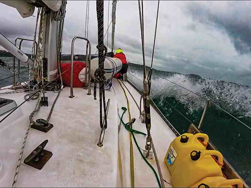
The anchor chain vibrated beneath my hand as Scott hit the throttle and Quetzal eased astern. That’s not what I wanted to feel, the anchor and chain skidding along the bottom, and I willed the usually reliable 66-pound Bruce to set. It chattered, then seemed to bite, then chattered again. We were tired, cold to the bone and ready to drop below for a hot meal, a wee dram of whiskey and a sound sleep. Instead I hit the up button on the windlass remote and started hauling up the anchor—for the third time.
We needed to take the strain off the windlass with the engine, and Gretchen, next to me on the bow, relayed my directions to Brant, who was positioned amidships, and he passed them along to Scott at the helm. The uncooperative anchor broke the surface with a necklace of thick weed—not a good sign—and Gretchen knocked it off with the boat hook as we circled Loch Stornaway one more time.
Scotland is an enchanting sailing area—with a few caveats. The season is short, the weather capricious, and anchoring is a challenge because the holding is often poor. Still, after two months of cruising the Inner and Outer Hebrides, I felt like we had mastered the quirks of anchoring in rock, weed and kelp. It was mid-September and we were bound for Cork, Ireland. It was a struggle leaving the city marina in Oban as we had to warp Quetzal, my Kaufman 47 cutter, off the pontoon in gusty winds. Tacking down the Firth of Lorne, we bucked foul tidal currents before resorting to motor sailing. Our progress was painfully slow, and we decided to hole up in Loch Stornaway, a shallow bay on the Kintyre Peninsula and unambiguously described on both the Imray paper chart and Navionics ENC as “dangerous.”
The obvious question is, why anchor in a dangerous harbor? For a couple of reasons. It was well-protected from the strong south winds and easy to enter in the fast fading light, and it would also be easy to leave in the morning, making it less “dangerous.” Also, there was an inner harbor that the local guidebook declared as a “safe” spot. Most important, we planned to stay just 12 hours, maybe less. The wind was forecast to shift to the northeast later the next day, leaving the anchorage sheltered through the night.
The so-called safe harbor was tiny and already claimed by a catamaran. I was not unhappy to make our way into the larger bay where we were the only boat. While compact anchorages can seem cozy, they’re actually the most dangerous place to be when things go wrong.
The fourth time was the charm, sort of. Once we’d picked the spot, in about 20 feet of water, I released the windlass clutch and let the chain run as Scott slowly eased astern. I wanted to make sure that the chain didn’t pile up but also didn’t want to load the anchor until we had at least 4-to-1 scope.
“Neutral,” I shouted and tensioned the clutch. The anchor seemed to set, and the bow swung into the wind. I tried to ignore the tiny chattering in the chain. “Slow astern.” The anchor held. “A little more throttle.” The anchor was holding, but I sensed it was tenuous. Usually I put the engine near full astern for at least 30 seconds to make sure the hook is well-set. Instead, I paid out more chain for a scope of 7-to-1 and shouted, “OK, Scott, it’s good.”
Making my way back to the cockpit, I wondered if I should dig out the 100-pound Luke storm anchor buried in the lazarette but quickly dismissed the idea as being paranoid. The wind was actually lying down, and with two anchor alarms and four crew aboard, we would be alert to any change in conditions. Besides, we’d be underway in less than 12 hours.
I slept fitfully and was in the cockpit mere seconds after the anchor alarm went off just after midnight. We didn’t’ seem to be dragging, just swinging, and I reset the alarm and confirmed my bearings on two lights ashore. Scott joined me in the cockpit a couple of hours later when the alarm went off again. We studied the plotter; if we had dragged, it was a short distance and the anchor seemed well-set—in fact, better than before.
We discussed resetting the anchor but decided against it. The dark sky was ominous, and it was drizzling. We also plotted the safe course out of the harbor: “It’s 230 degrees magnetic; lodge that in your brain,” I told him. At latitude 56 degrees north, we were only three hours away from first light, when I planned to get moving no matter the conditions. I dozed in the cockpit. When the anchor alarm went off at 0300, we were definitely dragging, and this time it was serious.
The wind had veered, well ahead of the forecast, and was blowing hard. I started the engine and bellowed, “We’re dragging; everybody, now, let’s go.”
Scott, pulling on his jacket, took the helm. “You are going to have to steer aggressively,” I told him. “We are going to get the anchor up and then get the hell out of here.” Gretchen and I dashed forward, leaning into the driving rain and biting winds. Brant was the relay man, but before he could say a word, Scott shouted, “Oh shit”; he could see rocks right off the stern. From the bow, without the glare of the cockpit lights, I could see them too. They were terrifyingly close.
“Full ahead,” I screamed, and we frantically started to bring up the anchor. The boat came to a sudden stop and pivoted violently. The anchor was stuck. “Neutral,” I yelled, and the windlass breaker tripped. I flew below and reset it. Scott tried to maneuver the boat back into the wind, Gretchen operated the windlass, and I peeled the chain off the gypsy by hand. Then the windlass jammed again. When the breaker tripped for the third time, I told her, “We’re going to have to pull it up by hand.”
“OK,” she said, and if she was scared, she didn’t show it. We had more than 100 feet of chain to haul in.
Suddenly we were close to the rocks near the northwest corner of the bay. “Steer south, Scott! Brant, tell him south, south, south!”
“I am,” Scott shouted.
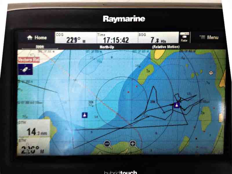
“No, this way,” I gestured wildly. We gained a little breathing room, and Gretchen and I hauled in a few more feet of chain. We were exhausted and confused: How could the anchor be stuck while we were careening all over the bay? I hurried back to the cockpit. Scott was right: The plotter showed him steering south, but we were drifting north, right toward another shoal.
“Forget the plotter, Scott, it’s useless. The direction is way off. We have to steer by compass alone, and by my directions from the bow, I can see better from up there,” I told him.
We would later learn that the combination of very slow forward speed while crabbing to leeward made the GPS heading erratic and inaccurate. The plotter was not fitted with an independent heading sensor, and relied on the GPS to extrapolate a heading based on the course and speed data it had collected—and this was almost our undoing.
In the midst of the mayhem, a bright shore light was focused on us, and a few minutes later a skiff approached. A local fisherman had come to help, and I thought to myself, Only in Scotland would someone come out in this weather. He suggested we try to pick up a mooring in the “safe” spot of the harbor. That would have required us dropping the chain and rode overboard, a scenario that I wanted to avoid. I suspected that within seconds of releasing the anchor we’d be washed ashore. Also, the idea of maneuvering among the rocks to find and then pick up a mooring in what were then gale-force winds seemed foolhardy, especially without our main anchor. The fisherman, who’s brogue was almost indecipherable, wished us luck and disappeared as mysteriously as he’d arrived.
Scott had his bearings now, and aided by Brant, who maintained his night vision, steamed toward deeper water in the center of the bay. Gretchen and I pulled with all the strength we had and made progress. The chain was draped in kelp, which explained why we were dragging even though the anchor appeared well-set. One minute the kelp had a death grip on the anchor, and the next minute it was free. Then it would snag the anchor again.
Suddenly we were close to the rocks on the south east side of bay. “Neutral, neutral, astern. Now!” Scott later told me the depth sounder had gone almost instantly from 18 feet to 8 feet, leaving a foot below the keel. Slowly we drifted away from the shore.
“This damn bay is a lot smaller in the dark,” Gretchen said, catching her breath. “Listen,” I told her, “we are going to be OK, I know it—but if we do lose it, if the engine dies or the chain breaks and we go on the rocks, whatever you do, stay with boat. Even if she breaks up, it is safer aboard, at least until first light.” Picturing Quetzal on the rocks sent shivers down my spine.
During a very brief lull we managed to haul in more chain, maybe 20 feet, then 30 feet more. We seemed to be making progress toward the outer harbor. Then Scott had an idea: “Let’s secure the chain and see if we can drag it out into deeper water. It’s just the kelp holding us now, but it’s still too heavy to lift.” It was worth a try. If the anchor remained fast, at least we’d be near the entrance to the bay, where it would be safer to let the chain run, drop the anchor, and motor out of Loch Stornaway once and for all.
It worked. The depth sounder went from 15 feet to 20 feet, and then we crossed the 30-foot (10-meter) contour line. We were out of the bay and dragging the anchor behind us. We kept steaming until we were in deep water and then slowed down. With all four of us pulling, we hauled the anchor aboard at last. Nobody felt like sleeping as we motored slowly south awaiting the light of day.
John Kretschmer’s latest book, Sailing the Edge of Time, is now available in paperback and as an audiobook.
Electronic Confusion
Most new plotters are not fitted with independent heading sensors, which means that the boat must be moving—and traveling in a relatively straight line—for the computed heading to be accurate.
Adding a stand-alone electric heading sensor is not a major project. Also, some new mushroom antennas for chart plotters come with both GPS and compass sensors. Today’s electronic compasses usually include a three-axis accelerometer, making speed and course even more accurate. By adding a heading sensor, the chart plotter will have the ability to provide a true heading at all times, even when the boat is stationary.
Notes an engineer friend: “With the boat pirouetting on anchor and then with a scared helmsman, your COG would have been crazy.”
It was.


