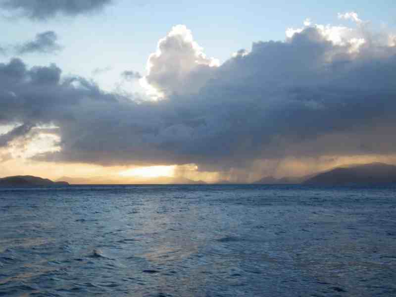
The first and second times that I tasted coffee happened in much quicker succession than anyone would have liked, thanks to my first dance with mal de mer. The year was 1987, I was 10 years old, and earlier that afternoon, my mother had heeded my unswerving pleas to help deliver Windancer, the family’s C&C 37, from Bar Harbor, Maine, to Long Island Sound. I can still remember how excited I was to stand next to my dad at the helm and wave goodbye to my mom ashore, and how I struggled — not 12 hours later — to hold my seasick head perpendicular to my shoulders as lightning flashed staccato fingers across the inky sky and Windancer’s bow slammed into the Gulf of Maine’s confused seas. While I didn’t exactly pass my first offshore test with high marks, I gained early insight into the real-world importance of accurate offshore weather forecasts.
Modern-day mariners enjoy far better weather information than the scratchy VHF broadcasts that we listened to on that stormy night on the Gulf of Maine. Thanks to advances in communications and significantly more sophisticated weather-prediction capabilities, today’s weather forecasting and weather-routing products give sailors impressive tools to avoid rough weather and take advantage of conditions to reduce passage times. Here’s a look at different options, the technology behind them, and ways you can best leverage all this information while underway.
Marine-weather tools can be broken into two categories: computer-based weather-routing software, and satellite- or Internet-based forecasting, which is integrated with a boat’s navigation-instrument displays. While the technologies are different, all of it depends on connectivity, whether it’s by Wi-Fi, cellular hotspot, satellite or single-sideband radio. Once devices are connected, data can be downloaded from a number of sources, including government agencies, like the National Oceanic and Atmospheric Administration, and private sources, such as Ocens and SailGrib.
Satellite-based weather services such as SiriusXM Marine deliver reception far outside of Wi-Fi or cellular coverage, but they require a dedicated, networked receiver that ties into your navigation system, as well as a subscription plan. (Receivers, commonly called black boxes, are available from all of the major marine-electronics manufacturers; see manufacturers’ websites for pricing information.) SiriusXM Marine users can choose between three different levels of service: Marine Inland, Marine Coastal or Marine Offshore. Bluewater sailors will want the Marine Offshore plan. However, globe-girdlers need to understand that SiriusXM Marine’s coverage footprint is not global; it is limited to the continental U.S. and international waters extending “hundreds of miles” into the Atlantic and Pacific oceans, as well as the Gulf of Mexico and the Caribbean Sea (see siriusxm.com for specific coverage details).
SiriusXM Marine customers pay a flat monthly fee that can range from $13 to $55, irrespective of how frequently they use the service. Depending on the type of subscription, users can access weather information that includes weather-radar overlays, offshore wind and wave forecasts, and marine observations from weather buoys. The information for these forecasts is supplied to SiriusXM Marine by the Weather Company (formerly WSI), and combines data from NOAA with information from other government, research and commercial sources to create proprietary weather forecasts using advanced post-processing and data-analysis software. These forecasts are then automatically pushed to subscribers.
For sailors cruising beyond SiriusXM Marine’s coverage map, or for those who want a second opinion, Internet-based service providers such as Theyr deliver detailed weather forecasts. Theyr employs different weather-data sources in different global regions and runs this data through proprietary forecasting models on a supercomputer, allowing its experts to interpolate additional data to create detailed forecasts. Theyr’s GRIB files play nicely with computer-, phone- and tablet-based routing software available for Linux, Windows and Apple platforms.
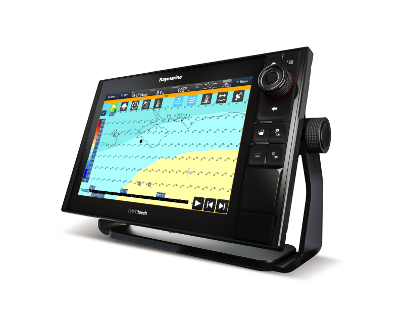
Taking things a step further, Raymarine and Theyr recently announced a partnership to deliver forecasts to Raymarine chart plotters through a subscription service that starts at about $15 per month. Users can tap into this content via Wi-Fi, cellular hotspot or satellite, but using this service with a cellular or satellite connection will add to your data usage charges.
Users can control the amount of data they consume, however, since Theyr Weather uses a “pull” model, wherein users manually select the forecasts they want to download to help contain costs. “Users can constrain the size of the download,” says Jim McGowan, Americas marketing manager at FLIR Maritime, parent company of Raymarine. He’s seen downloads as small as 25 kilobytes and as big as 15 megabytes. “For example, a user can download the weather for Puget Sound rather than the entire North Pacific,” he says. These files are saved to the nav system’s internal hard drive or a micro SD card.
While satellite and Internet weather services provide users with a huge amount of information, these forecasts are displayed simply as a graphical layer overlaid on a chart. The chart plotter doesn’t perform the actual weather routing, notes McGowan, but rather shows you the variables. Weather information is not connected to the chart plotter’s routing functions, but the plotter can display the conditions to be expected along a particular route. Much like radar imagery, SiriusXM Marine and Theyr Weather also provide a look at what’s ahead, but users need to know what they are seeing. “It’s not like getting a forecast on your smartphone,” says McGowan. “These services visually show you the forecast, but you need to know how to interpret the arrows and barbs.” These are the symbols that show anticipated wind direction and speed. Typically, each full barb represents 10 knots of wind speed; a half-barb depicts 5 knots.
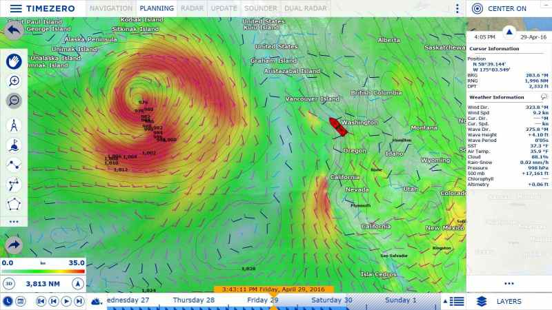
While McGowan suggests that Raymarine chart plotters might eventually tackle weather routing, for the time being, this powerful tool is largely limited to website services, including PredictWind, and computer- and tablet-based software, including Adrena at $700, Expedition at $1,295, and TimeZero (what used to be Nobeltec and MaxSea) at $800.
“Weather routing today is about speed, safety and comfort,” says Frédéric Algalarrondo, TimeZero’s group sales manager. “The fastest route isn’t always what a sailor is looking for. They want a safe trip and an optimal time, so we added parameters so that a navigator can select the fastest route and avoid the high winds and waves.”
Given TimeZero’s well-honed racing pedigree, including numerous wins in the singlehanded, round-the-world Vendée Globe race, it’s not surprising that this software uses a boat’s performance-characteristic metrics, called polars, to determine its best route from Point A to Point B in light of the forecast. Polars can be either manually imported or downloaded from TimeZero, which maintains a database for several hundred different vessel designs. If your boat’s polars aren’t available, Algalarrondo advises using the metrics of a similar sailboat.
Considering Furuno’s interests as a part owner in the former Nobeltec, it’s also not surprising that TimeZero software plays nicely with data from Furuno radars and sounders. While this is good for sailors running Furuno navigation equipment, TimeZero can also read NMEA 0183 data, allowing it to be brand-agnostic with NMEA 0183-compatible electronics such as wind sensors and speedos.
TimeZero’s latest software, called TZ Navigator, is touch-based and intuitive. To use it, a Windows-based PC (see TimeZero’s website for system requirements) must be running TZ Navigator ($500) and the TZ Routing Module (sold separately; $300), polars must be loaded, and the computer must have access to the boat’s GPS data. Algalarrondo says most cruising sailors also integrate AIS and wind-instrumentation data.
Users then download a current weather forecast from TimeZero’s servers to their PC using available communications. (As with Theyr Weather, Algalarrondo suggests users download judiciously to preserve their data plans.) TimeZero has agreements with different global weather providers, including NOAA for North America, which supplies TimeZero with raw data. This raw data is run through various weather models, and a 16-day forecast is sent to the PC as a GRIB file.
Once the file is downloaded, navigators can use the software’s time bar to drag the forecast chronologically forward to peer into the modeled future, or they can select the routing tool and let the software compute the fastest routing. Within auto-routing, users can set custom parameter options — for example, maximum and minimum acceptable wind speeds and wave heights. Alternatively, cruisers can use the software to plan their optimal departure time based on tides and weather. Users can review their expected sailing angles and name and label their routes, which are detailed in a table that can be copied into Excel for logbook purposes. Once all factors have been considered, the user activates the route, and all germane route information is displayed at the bottom of the screen.
One of TZ Navigator’s newest features is a safety check that helps you avoid buoys and rocks by analyzing your route based on depth and vector charts. This includes a smart cross-track-error feature that determines a route’s safe leeway. On your computer screen, safe routes are green, while routes that are too shallow or otherwise unsafe are colored red. Users can adjust their routing at any point, and TZ Navigator will recalculate its safety check accordingly. Once underway, the software can trigger auditory and visual alarms if a sailboat treads too close to a navigational hazard. While TimeZero is significantly more sophisticated than the original MaxSea software, TZ Navigator’s creators wisely preserved some of the older features in the latest software. For instance, the software calculates the maximum distance that a boat can sail in 15-minute periods given forecasted conditions; these are marked on the PC’s chart-plotter page with a series of wavy lines, called isochrones. TZ Navigator calculates the fastest course to the next waypoint through the isochrone bands, marking it with a black line.
TZ Navigator was specifically designed to work on older or lower-speed computers or Windows and iOS-compatible tablets (see www.nobletec.com for specifics). “It’s not much of a system requirement,” says Algalarrondo. “I’ve used it on a $99 Dell tablet and it worked perfectly.”
Given that many well-equipped cruising boats carry both chart plotters and a computer or two, there’s little reason not to stack the routing odds in your favor and take advantage of satellite weather and computer-based weather-routing software. Granted, there are cost considerations, but that’s a fairly low hurdle in light of the added safety and comfort that these technologies afford. After all, if we’d had today’s technology back in 1987, I might still be a coffee drinker.
David Schmidt is CW’s electronics editor.


