After owning the same sailboat for a good long spell, I naturally became quite familiar with the electronic navigation kit, including our modest (by today’s standards, anyway) Garmin chart plotter. That is to say, when I needed to, I knew where to find most of its features without pushing too many buttons or resorting to the dreaded user manual.
That’s not the case, though, when I step aboard friends’ boats and encounter less-familiar brands of plotters, often set up in peculiarly whimsical ways, or when I take the occasional charter and try to reset the previous skipper’s preference for, say, chart soundings in fathoms or meters instead of feet.
And then there are those sea trials aboard newly launched sailboats that may or may not have calibrated instruments or even a cartography chip in the plotter, as was the case aboard a large cruising cat I found myself on in an unexpectedly shallow corner of Florida’s Biscayne Bay.
Here’s my take on Situational Awareness 101: Having easy-to-use, familiar nav equipment isn’t just a convenience; it’s a real safety issue when you suddenly find yourself tacking into unfamiliar territory or when sea conditions change unexpectedly. That’s not when you want to go scrolling through pages of unfamiliar menus looking for settings and information such as tides and current.
As the Boy Scouts like to quip: Be prepared. And with relatively inexpensive prices for hardware and plenty of free or low-cost apps among which to choose, it’s pretty darned easy to put together a take-it-with-you navigation toolkit that can double as a backup should the primary system on your own boat fall prey to the electron demons.
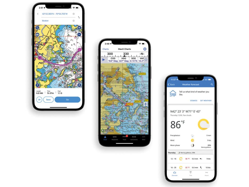
I’ve used the free navigation app iNavX for a while now. I have it on my iPhone (it’s also available for Android) and use it mostly to check my surroundings underway, and to get an idea of what might lie between my location and the next waypoint.
Call me old-fashioned, but I find planning longer routes much easier on a bigger screen such as what might be found on a tablet or multifunction display, or on paper charts. So, my first step was to contact customer support at iNavX to see what I should look for if I wanted to move up to an iPad. They promptly recommended any new iPad with cellular capabilities because it would have a built-in GPS receiver that works without a Wi-Fi signal; a used or refurbished device would need the same, I was told, plus it should have at least 64 GB of storage and be able to run iOS 13 or later software, or, even better, iOS 15 or newer software.
It took a little patience and hunting online, but I found an iPad Air 2 that met those specs on Amazon for just under $240. Had I searched longer, I probably could have found something suitable for even less, but with an upcoming trip, I was eager to get charts downloaded and sorted.
One of the things I love about iNavX is that it provides free access to charts from the National Oceanic and Atmospheric Administration. There’s also an in-app store with offerings such as iNavX Professional+ charts, Blue Latitude Charts for Mexico, Explorer Bahamas, Waterway Guide, AIS Live coverage and Theyr Premium Weather. iNavX is also adding inland waterway cartography.
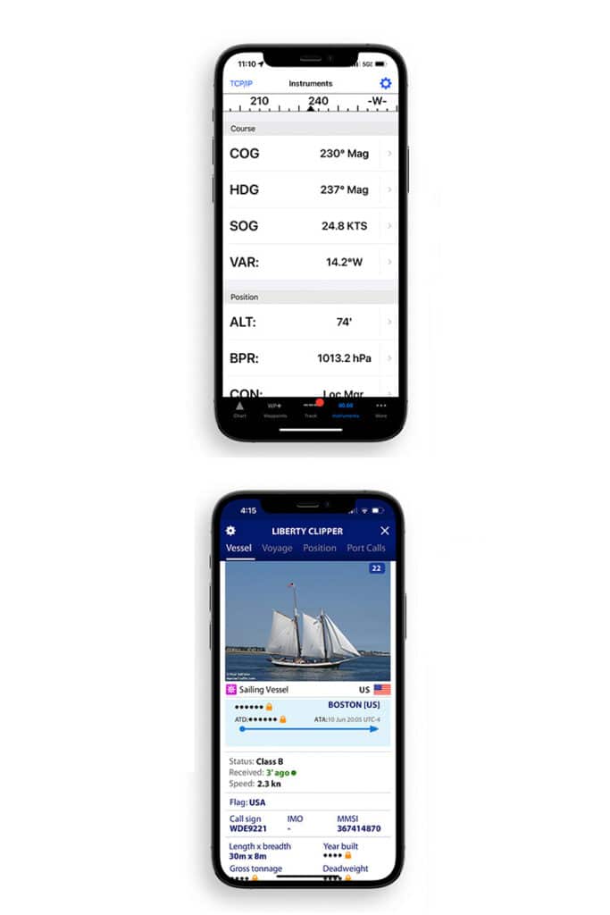
In basic navigation mode, iNavX is easy to use. You can set waypoints with the tap of a finger, plan out routes, view bearings in either degrees true or magnetic, get speed over ground, and customize a long list of other chart settings. You can also pair it on your phone or tablet with a vessel’s networked chart plotter to monitor depth, wind, engine, batteries and the like.
If you already have an AIS receiver or transponder on board, the app can display targets in chart mode. If you don’t, iNavX AIS Live coverage is available in some areas for a fee. The AIS Live server provides AIS targets within 30 nautical miles of your boat.
The price is right, though I initially found juggling the free NOAA raster charts a bit daunting. They are listed by region, and each chart needs to be downloaded for use. The USA East, for instance, lists charts from the US Virgin Islands to Cuba and northward to the Canadian border. That’s a lot of unfamiliar place names to scroll through.
The Professional+ charts also need to be downloaded, but they are listed by state and are much easier to find. Regional sets, such as the USA and Canada, can be purchased for around $25, and updates are included in the subscription fee.
For fear of being perceived as a big spender, I also downloaded Navionics’ latest Boating app and purchased cartography for the US and Canada, also for just under $25. Navionics offers similar packages for just about anywhere in the world you’d care to sail, and the charts are the same as what’s available on Garmin (its parent company) chart plotters. Navionics recommends an Apple device running iOS 13 or later.
The newly launched iNavX Professional+ chart series offers premium vector charts delivering country-specific coverage at a very reasonable price.
The app lets you add a number of layers of information on its cartography and download daily chart updates. It also provides some serious navigation power, including Auto Guidance+, which will plot a route automatically. Basic navigation is fairly intuitive, and route planning is as simple as tapping the chart to set a waypoint or route, a feature that would be quite useful when planning a sailing vacation in some new, warm and sunny place.
A few precautionary words about auto routing, though: Before relying on it, carefully review where the route will be taking you. Setting a course from my home north of Boston into Boston Harbor, it would send me through a narrow piece of water called the Small Boat Channel, which is probably fine for a powerboat, but it can be a nightmare for a vessel under sail in certain wind and current conditions. And on any charter, remember that the software might not account for areas where the charter company doesn’t want you to go. Straying into the wrong place when following a machine-generated route might cost you your security deposit if the boat should be damaged.
Navionics provides a number of ways to customize charts, with overlays for satellite imagery, relief shading to show depths, and sonar contours. Weather, tide and buoy reports are all included, and the app can pair with onboard AIS receivers.
C-Map cartography, which I also use on the iPad, has similar features, and the same caveat applies when using its route-planning capabilities. C-Map charts are free when connected to Wi-Fi; offline cartography access and extended weather are available only to premium subscribers.
While all of these nav apps can provide AIS data when paired with an onboard receiver, another handy tool is the app from Marine Traffic, which displays near-real-time AIS information for vessels worldwide. The free version of the app provides interesting information about targets, including flag of registry, call sign, MMSI number, speed and size. You can use the app to search for ships and pleasure boats by name, or scan a harbor to see what’s anchored or underway nearby. Marine Traffic’s starter plan, which costs around $10 for a year, adds a number of other tidbits about vessels, ports, ship’s tracks and weather maps. It’s all pretty cool stuff to have at your fingertips.
Before relying on auto routing, carefully review where the route will be taking you. What may be fine for a powerboat could be a nightmare for a vessel under sail.
I’ve also loaded up the iPad with a few of my favorite weather apps, such as Windy, Predict Wind, Storm Radar, WindAlert and SailFlow, and I’ve added links to regional NOAA text weather forecasts so that they are available as Wi-Fi allows. And I’ve downloaded PDF copies of a few other free NOAA publications, including Coast Pilot 1 and Coast Pilot 2, which give detailed coastal information about the waters from Eastport, Maine, to Sandy Hook, New Jersey. I also have the US Coast Guard’s Light List, Volume 1, covering the Atlantic coast.
With my new toolkit in hand, I’ll be ready to plan my next trip ahead of time and be able to change waypoints on the fly using apps that are quickly becoming old friends.
Boat of the Year judge and CW editor-at-large Mark Pillsbury is a die-hard sailor who has owned a number of sailboats, including a Sabre 34, on which he lived for 15 years.