While sailors successfully cruised the world’s oceans long before weather-routing technology, today’s offerings can shave passage times while also affording more comfortable rides. Better yet, some of these choices play nicely with low-cost, low-bandwidth satellite-communication options, providing sailors with up-to-date forecasts almost anywhere around the globe. Here’s a look at how this technology works and how you can access it without decimating the cruising kitty.
Weather routing can seem complex — and its behind-the-scenes calculations are not plain sailing — but for end users the process involves two critical pieces of information: accurate weather forecasts, which come in the form of Gridded Binary (GRIB) files, and the vessel’s performance characteristics, which come in the form of polars. Polars are developed by the manufacturer for each particular model, and predict a sailboat’s speed through the water at various wind speeds and angles. Here it’s important to note that, while private weather-forecasting and weather-routing services use GRIB files, the raw data for these files is typically collected by government organizations such as the National Oceanic and Atmospheric Association, which builds its free Global Forecast System, or GFS files, every six hours. The European Union’s European Centre for Medium-Range Weather Forecasts (ECMWF) releases fee-based GRIBs twice daily.
Once released, third-party companies can manipulate the data and create forecasts using proprietary algorithms. For example, PredictWind, which is available as an app (Windows, Mac, Android and iOS friendly) or as a cloud service, offers two proprietary forecasts: PWG, which is based on GFS data, and PWE, which relies on ECMWF data. “We’re the only private company in the world running full global weather models twice per day with two [proprietary] outputs,” says Nick Olson, one of PredictWind’s two principal developers.
While long-range GRIB files (sometimes extending out to 16 days) are available, all navigators worth their salt understand that newer forecasts always outshine old information. Also, given the size of some GRIB files and the potential data costs and downloading times involved, navigators are cautioned to only download the forecasts that they need, rather than files for an entire region.
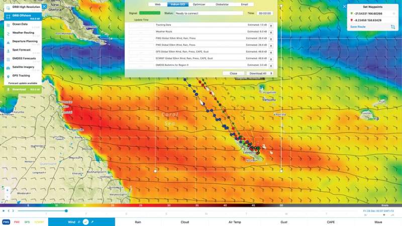
When planning a voyage, a navigator downloads GRIBs that cover the area from Port A to Port B and imports the data into weather-routing software, an app or cloud service, along with a planned departure window. “Weather routing takes into account the weather forecasts for the intended journey and plots where it thinks you’ll be relative to the predicted weather because it knows your boat’s predicted speeds in different conditions,” explains Olson. Additionally, weather-routing software can help users determine the optimal departure time and routing based on user-specified parameters. These parameters can include maximum acceptable wind speeds or wave heights, as well as the percentage of time that the boat will be on a particular point of sail.
Savvy navigators use weather routing to ensure comfortable rides, reduce the amount of time motorsailing, and — most importantly — determine the fastest, most efficient course to their next anchorage. Depending on the product, some weather-routing services (for example, PredictWind) will create several possible routes based on different weather models (using GFS or ECMWF) or different departure times, allowing the navigator to compare and contrast their options. “Users still need to make decisions and understand the weather,” cautions Olson. “We don’t want navigators to just blindly follow the weather routing — we want them to know why, and to help them better understand where they are in the weather cycle.”
Weather-routing software can either reside locally on an onboard computer or in cloud storage. In the first scenario, with an onboard computer running a weather-routing program such as Adrena or TimeZero, a user downloads a GRIB file and imports it, along with their desired destination and any en route waypoints, into the software, which has the boat’s polars and uses this information to generate its best routing. Depending on the software that’s being used, a skipper will either manually enter polar information (often available from the vessel’s manufacturer or online) during the program’s initial set-up process, or they can see if their boat is included in the software’s database. Likewise, with app-based weather-routing products such as PredictWind, users download GRIB files and import them into the app, which does the heavy lifting.
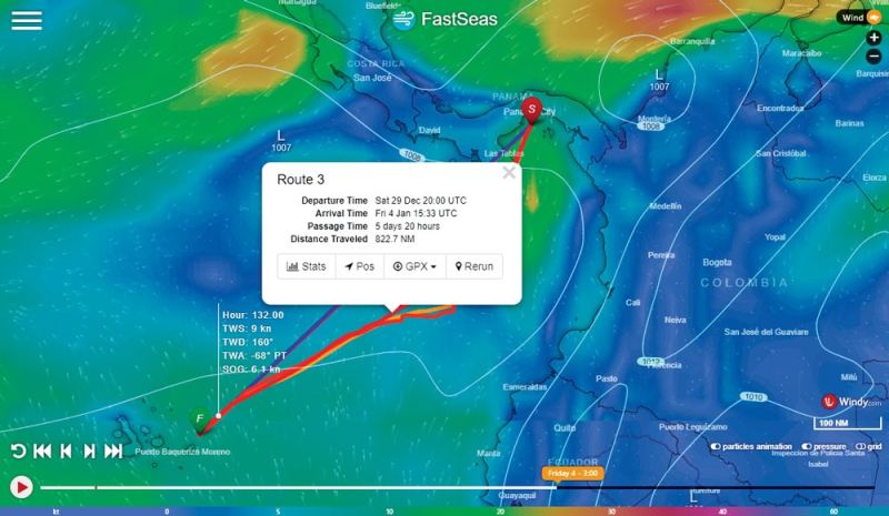
In the second scenario, users subscribe to a cloud-based weather-routing service such as FastSeas, which resides on Amazon Web Services, or PredictWind’s web service, where they create an account that includes their vessel’s polars. FastSeas allows users who don’t know their polar information to instead enter their vessel’s length at the waterline measurement and the boat’s best point of sail, and FastSeas will generate an estimated polar, which the user can manipulate to make more accurate.
Once created, users can either access their account via a service provider’s website or using a lower-bandwidth satellite option (more on this later). Websites typically allow users to graphically explore their route, which is sometimes overlaid atop cartography and animated weather videos. Low-bandwidth routing relies on small files, sent as email, that effectively list a series of waypoints, which are entered into the nav system, as well as the forecasted weather at the time of arrival at each waypoint.
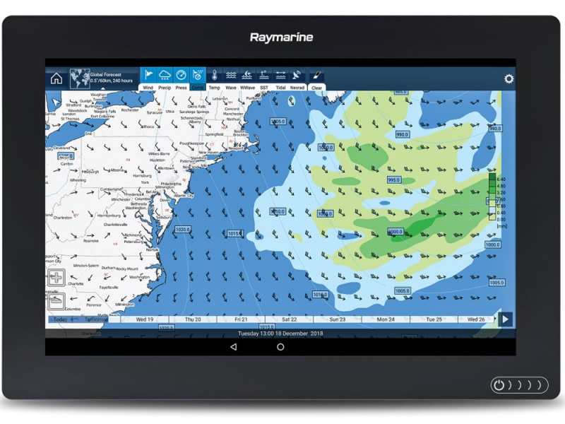
Alternatively, some chart plotter manufacturers, such as Raymarine, allow subscribers to view downloaded GRIB files on their chart plotters as graphical, read-only files. (Raymarine gets its weather data from Theyr.) These can’t be used for weather-routing purposes (at least as of this writing), but they are still helpful for evaluating weather and routing options that the skipper himself works out. “These services visually show you the forecast, but you need to know how to interpret the arrows and barbs,” says Jim McGowan, Raymarine’s Americas marketing manager (see “Reading Arrows and Barbs,” below).
While NOAA and the ECMWF produce GRIBs multiple times daily, polar information doesn’t change (shy of significant vessel modifications), so it’s important that the correct information is entered, otherwise weather routing quickly devolves into a garbage-in, garbage-out situation. “Polars are as important as the weather data. It’s all about seeing where you are going to be,” says Olson. He adds that users are almost always happier with their weather-routing investment if they vet their polars and gain experience using their routing software long before a big cruise. “Someone might realize that their boat doesn’t go 9 knots at 45 degrees to the wind, so they’ll need to change that,” he says.
In terms of downloading GRIB files, coastal sailors cruising under the dome of cellular connectivity or in reach of onshore Wi-Fi hotspots can easily access this information, but of course this is harder offshore. Traditionally, cruising sailors have used single sideband (SSB) radios coupled with Pactor modems for accessing GRIBs, but recent years have seen the plans of satellite-communications equipment and airtime costs drop. And while VSAT and FleetBroadband solutions exist, cruising sailboats less than 60 feet struggle to physically (and aesthetically) accommodate a dome, making satellite phones or other lower-cost equipment more realistic.
“Getting an SSB radio installed is expensive, and they’re not user-friendly,” says Jeremy Waters, the owner and creator of FastSeas and a longtime HAM radio operator. He notes that once you get an SSB set up and going, the cost for downloading GRIB files might be very little with a Winlink or Sailmail account, but there’s a strong argument that a Garmin inReach or an Iridium Go might be cheaper.
Olson agrees. “SSB is still a surprisingly large percentage of our market, but we don’t want people using it,” he says, adding that PredictWind recommends Iridium’s Go service to its customers. “The biggest reason is that it offers all-you-can-eat data,” says Olson. “If you’re out there, we want you to update your GRIB twice per day because the best forecast is always the most recent one.” While Go’s connectivity speeds are reminiscent of the 1990s dial-up days, the service allows users to download GRIB files with just a few clicks and will automatically resume downloading data (rather than starting afresh) should connectivity get disrupted.
RELATED: On Watch: Using a Weather Router
Alternatively, new low-bandwidth satellite options have entered the market in recent years, including Garmin’s inReach satellite communicators and Mazu’s mSeries system. In both cases, users send and receive small packets of information over Iridium’s Short Burst Data (SBD) network. Should the connection get disturbed mid-up/download, the system restarts where it left off, rather than restarting from scratch. While these products don’t provide enough bandwidth for surfing the net or making voice calls, they allow users to access up-to-date weather information. Iridium’s SBD service, which delivers near-global connectivity, will either support text-only messages that are 160 characters or less (Garmin inReach) or allow users to download GRIB files (Mazu). Weather-routing service providers that work with Garmin’s inReach system such as FastSeas instead employ a model where users send the company very specific weather-routing queries via email. Once received, FastSeas, for example, responds by sending users a low-volume reply email (depending on the size of a route, it can be sent as a series of emails). Alternatively, Mazu users can download and display GRIB files. “It typically takes 30 seconds to a minute to send an email and maybe five minutes to download a GRIB file,” said Craig Myers, Mazu’s product manager. “We’re not talking about megabytes or gigabytes here. We use compression and do enough work with the data that we’re only sending kilobytes.”
“For shore-side planning, the website is best,” says Waters, adding that the website graphically shows users how FastSeas generates its suggested routing. “Offshore, it’s all email requests, where the user sends us a crafted email detailing the product that they want, and we send [their routing] back.”
These emails — both from the user to the cloud and vice-versa — are measured in mere kilobytes. “Cloud routing is a big deal for cruisers,” says Olson about PredictWind’s cloud-routing service. “There’s less data to transfer, and it’s a more efficient way of doing it.”
Irrespective of how someone receives their weather-routing info or where the numbers are crunched, today’s off-the-shelf routing products are well worth their learning curves. “Ten years ago weather routing wasn’t as accessible,” says Olson, who pointed to satellite communicators such as Iridium’s Go or RedPort’s Optimizer as game-changers. “Cruising sailors today can get better weather and weather routing than Volvo Ocean Race sailors had 10 years ago.”
Aside from the accuracy of the different governmental and nongovernmental weather models — which should all improve in coming years thanks to the advent of additional and next-generation weather satellites such as the European Space Agency’s Aeolus wind-sensing satellite — the cost of satellite connectivity emerges as the only negative, and even this hurdle is surprisingly low. “Even people who cruise on my budget can afford it,” says Waters, who has sailed extensively aboard a 28-foot Bristol Channel Cutter since 1992. His FastSeas subscriptions run as low as $5 per month (with a one-year subscription; available monthly for $10).
So while all weather forecasting and weather routing is subject to some margin of error — it’s the weather, after all — today’s routing products and services deliver impressive results for sailors no matter where they plan to use them.
“There’s no real excuse for getting caught out in the weather anymore,” says Olson. Amen.
David Schmidt is CW’s electonics editor.
Reading Arrows and barbs
GRIBs contain a series of plotted station circles that represent the forecasted wind speed and direction for a given position and time. Empty station circles indicate calm winds, while barbs and arrows represent the wind’s predicted strength and direction. Long barbs represent 10 knots of breeze; short barbs signify 5 knots. A station circle with an arrow extending out at the nine o’clock position with two long barbs and a single short barb means that 25-knot winds are forecasted out of the west.
Satellite Weather
While not weather routing, SiriusXM’s Marine Weather (see siriusxm.com/sxmmarine for details) has long been popular with cruisers. This service uses a black-box satellite receiver to deliver National Weather Service forecasts, which can be viewed as read-only graphical files, to the boat’s chart plotter. “Our marine zones feature is a bit like weather over VHF,” says Geoff Leech, SiriusXM’s director of marine partnerships. “We have a clever way to include marine zones on the chart plotter. Users can pull up a detailed report about what’s coming in their area, or the area where they’re going.”
Vendor Contacts
Adrena: adrena-software.com, +33 (0)975.45.40.48; $750.
FastSeas: fastseas.com, subscriptions from $10 per month
Garmin: garmin.com, 800-800-1020
Iridium: iridium.com, 703-287-7400
Mazu: mazu-marine.com, 866-759-6283
PredictWind: predictwind.com, 970-470-8694, subscriptions from $33 per month.
SiriusXM: siriusxm.com, 866-635-5027; subscriptions from $13 per month.
Theyr: theyr.com, +44 (0) 207 396 1006; $15 per month or $100 per year.
TimeZero: nobeltec.com, 503-579-1414; $800.


