CO5ZYDLER01.jpg
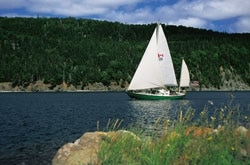
Off the starboard bow, daylight revealed the sharp lines of the Cape Breton Highlands, near the eastern tip of Nova Scotia. Feeding seabirds scattered among the waves as we charged down them. Kittiwakes bobbed on the surface, paddling feverishly when our bow threatened. Puffins chased food beneath the surface, flashing their orange feet in the light of dawn. After the 200-mile passage from Bonne Bay, Newfoundland, before an early-September northwest gale, Mollymawk, our 37-foot yawl, had made landfall on the eastern end of Nova Scotia, our gateway to the Bras d’Or (“Arm of Gold”) lakes.
The birds came from the islets of Hertford and Ciboux, the Bird Islands, nesting sites for puffins, razorbills, guillemots, kittiwakes, great black-backed and herring gulls, and great and double-crested cormorants. Sailing by, we watched the islands intently–for birds and for clues to the direction of the current. These bare rocks rose from the sea only a few miles from our destination, Great Bras dOr, the channel leading into the landlocked lakes, and we hoped the water rushing past their steep sides flowed with us.
Great Bras d’Or joins the ocean through a quarter-mile-wide funnel further squeezed by shoals and crossed by an 11-foot-deep bar at its entrance. The currents can reach six knots there, and when they run against large onshore seas, they create a boiling cauldron that can sweep the decks of low, narrow-beamed vessels like Mollymawk. Our calculations promised a fair tide, which carried us swiftly between the buoys marking the deep water between the breakers.
Inside the inlet, the wind dropped, the boom of the open sea receded, pine scent filled the air, and all became still: Wed reached the entrance to the Bras dOr lakes, the oasis of the Canadian Maritimes. The silent tide carried us under the 119-foot-high Seal Island Bridge. Six miles farther south, the wind returned through a low valley, the current eased, and we tacked leisurely by the white gypsum ramparts that flank Big Harbour, about two-thirds of the way down Great Bras dOr.
Approach from the North
In Great Bras d’Or, the contrast with our summer cruise in the Strait of Belle Isle, nearly 400 miles to the north, was stunning. Up there, an obsession to savor every moment but to avoid lingering in one place had dominated our days. Summers in the strait are short. While gunkholing the Labrador coast and sailing through the mountain shadows of Newfoundland’s fjords, the passing time ticked relentlessly in our subconsciouses. Summer berries grew plump in the Labrador tundra, and plants rushed to maturity in Newfoundland’s conifer groves.
Local fishermen advised us to head south at the end of August, warning that September brought stronger winds, around 40 to 50 knots, and the return of the ice to the Strait of Belle Isle. Bergy bits around the icebergs become hard to spot among the whitecaps, they said, even in clear weather. They werent exaggerating. Every time we passed a large berg, we had to zigzag around low-lying ice chunks that were as big as trucks.
At the beginning of September, the first large autumnal low swept from the west, promising gale-force northwest winds. We departed Bonne Bay just before the front crossed the strait, and our venerable Aries windvane kept Mollymawk ‘s bow plowing south. Under double-reefed main and working jib, the yawl tracked at hull speed, comfortably at first and later rolling as the seas grew larger. Under a sky crossed by streaks of pink, the intense red sun hovered at the horizon astern. The boat sped ahead on the crests of steep, tightly furrowed waves rushing southward.
The darkening sky slid down like a curtain, only to stop suddenly. Low on the northern horizon, an oval cell of cold glow suddenly shot high in the sky a beam of brilliance that penetrated the inky black: the aurora borealis, the northern lights. The brilliance slowly oozed down, filling to overflowing a bowl of light now widening from northwest to northeast. As the night progressed, searchlights from that glowing dome probed the dark above. Now and then an icy-blue tube of light rose like an apparition toward Polaris. The northern lights persisted until dawn, the perfect farewell from the high latitudes.
The powerful wind that had powered and pummeled our little ship southward veered gradually to become a pure northerly. With poled-out jib and the main eased all the way, we charged past the timid light on St. Paul Island, less than 20 miles from Cape Breton Islands tip.
Inside the Lakes
In the Great Bras d’Or, calm prevailed. From a tall, dead spruce, the resident bald eagle tracked our intrusion. Suddenly it plummeted, its talons cutting a wake as it closed in on its prey, but it rose without a fish. Bald eagles lack the osprey’s equipment for hooking fish–polarizing eyes, specially curved talons, and arched wings for gaining altitude with a heavy catch. Still, about 200 bald eagles nest along Bras d’Or lakes shores, feeding successfully by stealing fish from other species, including, in spectacular aerial duels, ospreys.
In Big Harbour, we circled to find a spot to anchor, watching for unmarked submerged remains of dock cribs left from the old gypsum mines on the western shore. A deep, narrow channel from the outer anchorage ran inland to Surprise Cove, so named by Cruising Club of America (CCA) members, where tall, precipitous cliffs were mirrored in calm pond waters–home for a drift of ducks nibbling on shallow weeds and itself a sanctuary within the inland lakes.
The southern end of Great Bras dOr terminates at Red Head, a high bluff of ruddy rock that runs along Beinn Bhreagh–Gaelic for “beautiful mountain”–the headland on which inventor Alexander Graham Bell built his summer home. After short tacks in deep water close to the shore, the Scots gothic mansion came into view astern while the town of Baddeck loomed ahead. Even today, Bells prominent past dominates this area, and the museum at the Alexander Graham Bell National Historic Site, which celebrates his many and varied breakthrough accomplishments, overlooked our anchorage outside the main harbor.
Baddeck has grown steadily as a yachting center, and resident boats on moorings fill the basin that has the best protection from the weather. Visiting yachts can tie up at the government wharf or at the Cape Breton Boat Yard docks, at the west end of the harbor. Bras dOr Yacht Club has a restaurant and offers a dinghy dock, hot showers, and, for a small fee, a laundry.
Today, Cape Breton Island and Bras dOr Lake epitomize peace, but the regions past has seen much cannon fire and swordplay. For centuries, Basque fishermen were based in the area during summers, and they hid this source of rich fish stocks from the rest of Europe. In 1497, Explorer John Cabot claimed the island for King Henry VII, but this didnt prevent the enterprising French from colonizing it. From Cape Breton, their privateers raided New England until 1744, when the British colonists attacked and took Louisburg, the French fort on Cape Bretons Atlantic coast.
Cape Breton Island became a British naval reserve until the 1780s, when the first civilian settlers received land grants. Now, memories of the French linger only in the names of places they used to frequent. Boularderie Island, on the south side of Great Bras dOr, for example, is named for a French navy officer who, until his capture, was a nuisance to the British. Man of War Point on that island commemorates a French warship yard there that was burned to the ground by British torches.
The Geographic Connection
By the time Alexander Graham Bell arrived in Baddeck in 1886, the town was already prospering as a shipbuilding and trading center, and Scottish, Gaelic-speaking farmers tilled the nearby hilly land. Bell adored the place, which became the site of his residence and a laboratory for his projects. Although Bell is best known as the inventor of the telephone, his early work helping the deaf converse led to this communications breakthrough. His mother was deaf, his father worked as a speech specialist, and Alexander married a young deaf woman, Mabel Greene Hubbard.
Way ahead of his time, Bell developed flying machines and hydrofoils, and he suggested replacing fossil fuels with alcohol produced from farm refuse. And he experimented with genetic modifications through crossbreeding of sheep. The National Geographic Society was formed in 1888 with Mabels father as a founding member. Ten years later, A.G. Bell became its president and roped in Gilbert Grosvenor, his daughter Elsies beau, to become editor of the societys journal. Thus was born the National Geographic magazine we know today.
Alexander Graham Bells influence permeates the town. Every summer, the museum complex attracts thousands who wish to learn more about his life and to admire the original models of speed machines designed to cut through air or skim on water. His descendants spend summers at Beinn Bhreagh, and the yawl Elsie, launched in 1907 as his daughters wedding gift, still sails off Baddeck.
Bras dOr cruisers can easily escape the summer crowds. We had only to sail a few miles south to vanish among the wooded hills and meadowed shores of Maskells Harbour. From there, we pressed on southward through Barra Strait. The bridge tender must have been a sailing man, for the span opened at the perfect time, allowing us to sail right through with the fair current and on past Iona village on the north shore.
|
|
| |
|
|
| |
| ©Tom Zydler|
| |
|
|
| |
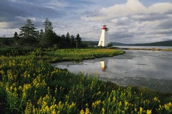
| The east entrance to Baddeck’s harbor is marked by the lighthouse on Kidston Island, named after a young mid-18th-century Loyalist militia captain who wed the local storekeeper.* * *|
| |
|
|
|
New Scotland
Hebridean names hint of Cape Breton Island pioneers who migrated from Scotland in the early 19th century. Iona’s Nova Scotia Highland Village, a model of an early settlement, lies only a mile and half from the government wharf on the north side of the bridge. A genealogical center there lets you trace your own Scottish roots, free of charge.
The northerly breeze allowed us to swing around the corner into Pipers Cove, near the entrance to East Bay. Hundred-foot red cliffs plunge into the clear lake water, which is deep right up to the base of the buttresses. Pipers Cove faces the widest part of this inland lake, which can get very choppy when the wind pipes up from southerly quarters. However, accurate VHF-radio forecasts by Environment Canada (http://weatheroffice.ec.gc.ca) give plenty of warning, and protected harbors abound.
Just before the next low arrived, we escaped to Little Harbour in the Malagawatch Basin area. An extremely narrow channel led into a wide lagoon, its shores lined with low trees and flooded meadows of flowering grass and sedge. Kingfishers flew over the water with their rattling calls, and snowy egrets plucked smelts from the shallows. Cape Breton Smokehouse, famous for its smoked salmon, was visible among the trees on the west shore. The German couple who started the company arrived in Little Harbour on a large steel ketch, and they still anchor there.
The Bras dOr lakes experience far less fog than does the outside Atlantic, and apart from one day of drizzle before the passage of a depression, visibility while under way remained good. We holed up in Cape George Harbour for the wet days that followed. After a couple of boats departed, the anchorage became so placid in the embrace of fir-forested shores that we talked in whispers.
Cape George Harbour is a good departure point for St. Peters Canal, the southern exit of the Bras dOr lakes, about seven miles farther south, although several attractive coves closer to the canal could also put you in good position for the transit. Summer homes are on their shores, but owners are hospitable, and only rarely will a no-trespassing sign bar your way ashore for a walk.
Completed in 1869, St. Peters Canal was a boon to commercial mariners trading between the lakes and points south; their boats would otherwise have to be hauled by oxen over the narrow neck British Admiralty charts called the Haulover Isthmus. While today pleasure boats predominate in the canal, it was designed for 45-foot-wide vessels up to 230 feet long and drawing up to 16 1/2 feet. However, mast heights are limited to under 100 feet because of the power line a mile north in St. Peters Inlet.
Modern St. Peters Marina hides on the lake side just before the lock. St. Peters village has two museums: the Nicholas Denys Museum, named after the founder of a trading post in the area, with its collection of local artifacts, and MacAskill House, the restored birthplace of marine photographer Wallace R. MacAskill, with its sailing prints and camera collection.
We arrived at the canal wharf and phoned the lockkeeper, and 15 minutes later, we were tied up in the freshly painted lock. Half an hour later, wed reached the Atlantic through the lock, with its five-foot water-level range.
We slipped into St. Peter’s Bay, protected by Isle Madame and as flat as the Bras d’Ors themselves. But two hours later, Mollymawk was heaving on Atlantic swells in a rising westerly wind, the crew pining for the smooth Bras d’Or waters–the fogless, tideless oasis of the Canadian Maritime Provinces.
Tom Zydler and Nancy Schwalbe Zydler headed south last fall after an extended cruise to Newfoundland and Labrador aboard their 40-year-old, 37-foot Pearson Invicta yawl, Mollymawk. Nova Scotia is in this summer’s plans, too. Nancy and Tom are authors of The Panama Guide and The Georgia Coast, both published by Seaworthy Publications of Port Washington, Wisconsin.


