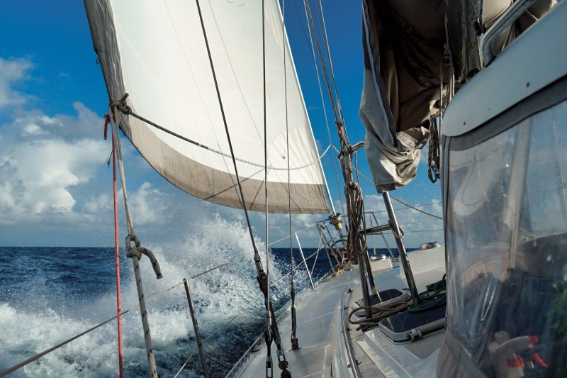
Because home is where the boat is, my wife, Behan, and I sailed our Stevens 47 Totem into 53 neighborhoods last year. Each destination, from the Marshall Islands to Japan, was new to us. Routing discussions were as regular as sunrise and coffee.
Can we arrive in good light? How stable is the weather window? How are we tracking for timing slack tide at the atoll pass? Getting to Japan posed a routing accountability test. At sea several days before arriving, we had to inform officials of the exact time we’d pull up to the dock plus or minus 15 minutes. Cue the weather-routing software to help estimate our time of arrival for certain-to-be punctual Japanese officials.
Routing software computes the route, or path, to the fastest ETA. Its computations are based on predicted weather, sometimes with parameters that favor comfort more than speed, and on boat performance metrics. It’s a little like Google Maps detailing the fastest route to a destination. Road layout, speed limits, traffic flow, speed traps and other slowdowns define actual and forecasted car speed, affecting arrival time. Distance divided by speed equals time—simple math calculated from changing but reliable numbers.
On the water, distance is easily found on a chartplotter by creating a route of the shortest safe navigational path to destination. Actual distance varies. Tacking and gybing, snake-wake driving at the helm, and other meanders for better wind, avoiding foul current or finding flatter water adds distance. We can account for these to estimate reasonably accurate distance, so we only need to determine boat speed to calculate ETA.
Predicting boat speed is not easy. It’s why many people find routing software to be unreliable. The issue is partly because of imperfect weather forecasting, but the bigger culprit is sailing differently than the boat speed assigned to given conditions.
Every sailboat has a potential maximum speed for specific wind speed and relative wind angle. Think of those two ingredients—wind speed and relative angle—as sailing horsepower.
Sailing horsepower increases and decreases as the wind speed and angles change from moment to moment. How fast that sailing horsepower will push a sailboat depends on the boat’s design: waterline length, sail area, displacement, wetted surface area, hull shape and so forth. A 60 sailing-horsepower moment will drive tall-masted, lightweight boat X faster than boat Y with the same length, but is heavier and under-canvassed.
From these design features, we can calculate theoretical boat speeds given specific wind speeds and relative angles. This is what we call boat speed polars, or polars for short, and bases for routing software to predict the distance a boat will travel over a specific time increment.
The name polars comes from polar plot, a type of graph showing theoretical boat speed for given true wind speed and true wind angles. It’s a clever visual aid to more easily see relative wind angles.
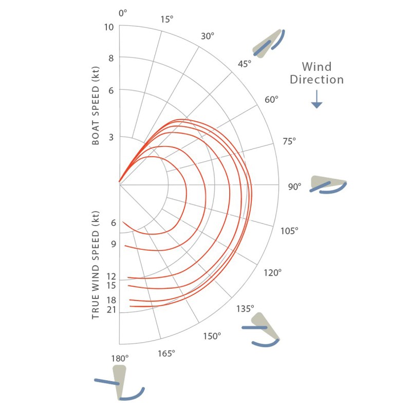
Boat polars evolved for racing sailboats. Take a given sailing-horsepower moment: How fast will boat X go? At which wind speeds and angles will it best perform? Implied but unstated is: How fast will it go with a perfectly clean bottom, a crew of rock star sailors eking every fraction of a knot, new and perfect sails for the conditions, every unnecessary pound left on the dock, and instruments displaying perfectly calibrated data so the crew can make this instrument sing.
My transition from racing sailor to cruising sailor included conflicting motivations. I like performance, except when the water is too cold to keep the bottom smooth. I like high-tech sailcloth sculpted into beautiful sails, but choke on the price. These realities, and more, don’t show up in formulas used to quantify boat design features into predicted boat speed.
Ignoring real-world slowdowns is why routing software gets it wrong. Sailing at 6 knots when polars indicate 6.6 knots puts the boat 10 percent behind. Real-world polars make routing software a powerful tool for better passagemaking.
Racing sailors take boat polars and then press the gas pedal harder to go faster. Cruising sailors? We need to pump the brakes to account for imperfect sails, trim and more.
Start with base polars for your boat or a boat with similar specifications. Preset polars are commonly available as options in routing software, such as the long list that PredictWind offers.
It’s also possible to create your own polars from data-collection tools. For example, OpenCPN charting software has a plug-in that will record and update the fastest boat speed for true wind speed and true wind angle. It works, but it doesn’t account for speed boosters like surfing on a wave or favorable current. Collected polars need to be tweaked.
PredictWind has a next-level version of this using their DataHub, with an AI element and additional data inputs. It’s a promising approach, though I haven’t yet tested it, for reasons that I’ll discuss below.
To tweak baseline polars with a real-world lens, you need to go sailing. Longer passages are better, but at least six hours will do. Just before going on a passage, run your routing software with at least two GRIB models. Assess the resulting GRIB forecasts and routes. Choose the forecast and route that seems the best one to follow. Then compare projected and actual positions. If the forecast was reasonably close, then the position should be as well. If not, the polars need calibrating.
From base polars, speed-adjustment fields dial polar up or down as percentage. They can apply to all the polar speed or those in a specific wind angle range, or to sailing at night. If your position falls behind the routing projection and then decrease appropriate fields by 10 percent to 20 percent, update the route. It’s not sophisticated or difficult, while being very effective. We’ve used this method to reach accurate polars on Totem, including subtle tweaks such as after getting a new sail.
After homing in polars over several passages, review how much change from the base was necessary. If you had to stomp on the brake pedal, perhaps there are ways to regain some of that lost speed. Performance is an element of safety, after all. Some causes are easy, some are costly, and some take dedication.
Bottom cleanliness: If baby bottom smooth is a 0 percent penalty, consider degrees of bottom fouling to an increasingly dirty diaper and awkward gait.
Propeller: Folding and feathering propellers reduce drag enough to boost a boat by roughly 10 percent.
Sail inventory: Cruising boats tend to have few sails because of the cost, stowage and effort to change sails. Chances are that the sails up in a given moment are adequately suited but not optimized to the conditions. When purchasing a new sail, improve on the size, construction and shape, without compromising longevity, for better performance.
Sail trim: Some cruisers are sail-tweakers, and sail faster for it. Others hear a fluttering leech as sweet music and lumber align. Polars adjusted to either style will give good routing results. Decent sail trim and speed-boosting methods, like trimming the headsail with a barber-hauler when not sailing upwind, are like easing up on the brake pedal.
Weight distribution: Pitching motion is slow, especially when wind is forward of the beam. Can you shift weighty items toward the middle? In our last refit on Totem, a new anchor chain shed more than 300 pounds from the bow, creating a notable reduction in pitching. (Please don’t stow a primary anchor away from the bow. It’s not safe to eliminate anchoring readiness.)
Instrument calibration: Boat speed and course over ground are accurate with GPS. Other transducers are less so, thanks to degrees of inaccuracy out of the box, growth on a speed paddlewheel or bird poo on a wind transducer, and even installation. A wind transducer misaligned to the boat gives the appearance of sailing closer to the wind on one tack than the other. I’d like to test PredictWind’s AI polars but need to resolve instrument gremlins, including a frustratingly awful new ultrasonic speed transducer.
Twenty-five years ago, I couldn’t have conceived of a mobile phone displaying a map, updating my car’s position and speaking out directions to guide me easily to an unfamiliar destination. As we pulled up to the dock in Yonabaru Marina in Okinawa, Japan, with 17 clearance officials waiting while mostly staring at phone screens, I wondered if any had concerns about arriving late themselves. Probably not, with their routing software directing them around traffic slowdowns across Okinawa.
Marine weather routing is much less precise, derived from many variables and forecasts. Still, it’s not the polar opposite of land-based routing systems once you get the speeds dialed in. With finely tuned weather routing, we arrived within a few minutes of our ETA.


