Furuno TZTouch
There were a lot of interesting new products and updates at this year’s Miami Boat Show. I discussed some smaller product releases in two earlier web articles, now here’s a more detailed look at what else was introduced.
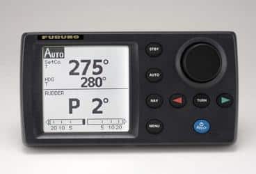
Furuno created a lot of buzz when their NavPilot 700 came out in 2011, with several very good features. The SafeHelm system, which automatically disengages the NavPilot steering control when it senses movement of the helm by whomever’s steering the boat is one, instead of using a button on the control panel to dodge around objects or other vessels. I like it because it’s quicker and far more intuitive, especially for rapid reaction to events. The autopilot reverts back to the vessel’s original course automatically or manually once the maneuver is completed. Another neat feature is the PowerAssist mode, which uses power from the autopilot’s steering pump to help steer the vessel manually, a “power steering” boost that would have been most welcome on at least one boat I used to run!
The NavPilot 700 also uses “self-learning, adaptive” software that “learns” how your boat handles and applies that knowledge to the autopilot. There are also different modes you can apply; of special note to sailors is the “Wind” mode.
NavPilot 700
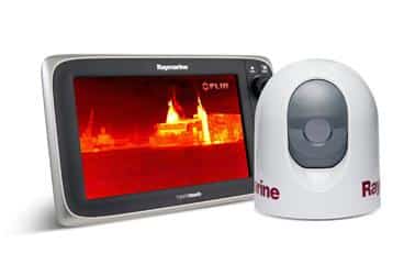
Furuno also announced a free update for its impressive line of NavNet TZTouch, which I’ve covered as a new product in the magazine. TZTouch 2.01 includes integration with FLIR’s M-Series thermal cameras, and the integration is all-encompassing. M-Series owners will now be able to direct the camera, lock on and track specific targets, and overlay field-of-view images directly on a chart.
The new update also includes Auto Chart Selection, improved Auto 3D Exaggeration, and pinch-to-zoom (previously only available in the 2D layout), functions. You can now also create waypoints directly from the Weather and Tide pages, which I think is a great feature for dealing with currents and weather. The icing on the cake is the ability to download free weather GRIB files directly from NavCenter (www.navcenter.com) or via an SD card.
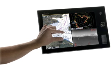
Speaking of NavNet TZTouch, it’s now possible to buy a black-box version of the TZTouch for use with any touch-screen display. This allows you to set up a custom navigation solution for your boat. The processor supports two DVI video outputs with a built-in scaler, so you can install two displays of any size. A small one at the helm station and a larger one down below in the nav station, for instance. As with the TZTouch Multi Function Displays (MFDs), you can create or connect to a wireless network to remotely view and control your TZTouch software via your smartphone or tablet. That same wireless access now gives you the ability to set up automatic updates for the system as well.
The TZTouch black box comes with free NOAA raster and vector charts, depth data for the entire U.S. coastline, and is preloaded with C-Map vector charts for all of North America. Want the World on your TZTouch? Connect the optional USB hard drive, which is pre-loaded with all the charts and high-res satellite images you’ll ever need for globe-girdling voyages. Check with Furuno or your electronics retailer for pricing. www.furunousa.com
Navionics held a press conference and announced some sweeping changes, which include a new chart standard, Navionics+, which replaces all previous versions of Navionics electronic charts. Designed to take full advantage of the new Navionics service is Freshdata, which provides users with a downloadable update for their charts which features the very latest information available, including crowdsourced depth information (see below). The initial purchase price, $179 for US and Canada, $249 for other regions, includes a year of Freshdata updates. Those who already have Navionics products such as Navionics Silver, Gold, Platinum+, and HotMaps Premium and HotMaps Platinum lake maps, and Marine & Lakes USA pay $99 for the update, and choose one of the seven global regions they need to download.
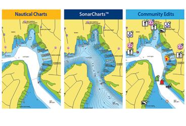
What really struck me is Navionics’ new Sonarcharts feature, which uses crowdsourcing to give users incredibly detailed sounding information. Crowdsourcing is a simple idea, and is a technology many of us use all the time without thinking too much about it. Whenever we use Google, Expedia, Yelp, or review-based online sites, we’re accessing crowdsourced information; feedback about restaurants or services that people have uploaded onto the Internet.
Navionics has seized that concept and run with it by using the logging feature found on depthsounders. Information gathered by your depthsounder can be loaded onto an SD or XS card on your chartplotter, then uploaded to the Navionics website by inserting that same chip into your computer. That user data is then integrated with official chart updates and other sonar logs and processed by Navionics, which then makes it available to users via the Freshdata update service. To load the latest data, you simply perform the above process in reverse, and load the new information on to your plotter.
Sonarcharts can be viewed on Humminbird, Raymarine, Lowrance, and Simrad chartplotters. Users of Navionics Gold, Silver, Hotmaps Premium, and Marine & Lakes USA products can access Sonarcharts for $99 using the new Navionics Updates chip. Users of Navionics Platinum and Navionics+ get the enhanced depth data at no charge.
Raymarine had a lot to talk about at the show, and all of it was pretty impressive. FLIR’s recent acquisition of Raymarine, which I’ve covered before, is obviously working out well for all involved, specifically the consumer.
First up is Raymarine’s newest MFD, the a-Series, a compact unit designed for smaller boats, yet packed with the same features offered on its larger displays. They’re touchscreen displays using Raymarine’s Lighthouse user interface, which is easy to use. Tablet and smartphone users will delight in the fact that these new displays offer full-function control from their phones and tablets, with apps available for Android, Apple iOS, and even the Kindle Fire.These new MFDs use a 50-channel GPS and can use Navionics cartography. The displays can join any already existing NMEA 2000 or Raymarine SeaTalk networks, making upgrading, or adding a new helm display a simple task.
If you’re looking for a larger MFD, the new gS Series may fit the bill. With edge-to-edge glass construction and slim bezels, the gS series is a sleeker-looking MFD than previous Raymarine plotters, and is available in 9-inch, 12-inch and 15.4-inch screen sizes. A dual-core processor and a separate, dedicated graphics processor makes for nearly instantaneous redraw and a crisp image. The gS MFDs support Navionics Platinum Plus charts, and those charts can be shared between networked displays.
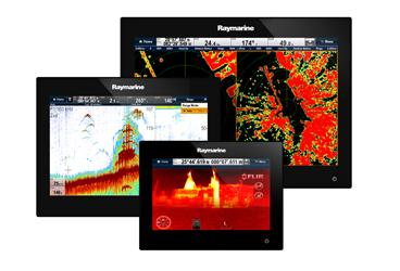
Until recently, thermal cameras have been too expensive and bulky for smaller vessels, which is too bad, because they can be outstanding additions to any boat’s navigation suite. Their ability to see in low visibility or night-time conditions make them perfect for picking your way through an unfamiliar harbor or crowded anchorage, and their usefulness in MOB situations is unparalleled. Thanks to the folks at FLIR, Raymarine is now offering a base-model camera at a reasonable (starting at $3,499.99) price, the T200. And at just 7 inches in height, and 5.9 inches in diameter, it’s perfect for mounting on a spreader.
The T200 is a fixed-mount camera, which means that it will not tilt, pan, or zoom, but mounted properly, it will be perfect for dead-ahead viewing. It’s a simple install as well, because it uses only two cables, one of which is a power-over-ethernet cable, the other a video output which goes directly to any MFD that has a composite video jack, and of course to Raymarine’s a, c, and e-series MFDs as well as the new gS MFD.
Other Raymarine new-product launches include the Evolution line of autopilots, which are designed to be incredibly simple to set up. You simply tell the unit on which type of vessel its been installed, the type of steering involved, and the drive type, as well as performance level, and you’re done. The EV sensor core, which is a compact unit about the size of a GPS sensor, has been designed to “sense” the environment (sea conditions, heading, pitch, roll, and yaw, etc.) and steer the vessel appropriately. The EV sensor package can integrate with either already mounted or new Raymarine hardware. The Evolution autopilots will be available in June 2013.


