When flying over the Atlantic Ocean, I like to keep track of the plane’s progress on the seat map in front of me. One small place I always notice, situated well off the coast of Nova Scotia, Canada, is a crescent-shaped sliver of land called Sable Island. Sable is a French word that means “sand,” and as I would come to learn, it aptly describes this outcropping that lies in wait on the great circle route to Europe.
I became intrigued by this remote 26-mile-long spit of an isle after listening to a lecture given by former Newport Bermuda Race chair Bill Barton and Dan Finamore, a curator and archaeologist with the Peabody Essex Museum in Salem, Massachusetts. After their 2010 presentation at the New York Yacht Club, I asked them if they would consider inviting me if they ever returned. My goal was to produce a documentary on Sable Island, and happily, that notion became a reality in August 2015.
Sable is not an easy landfall. It took two years of planning, and we had to apply for a permit from Parks Canada to land there. We were the only yacht granted permission to go ashore that summer. When we finally arrived, I discovered a beautiful, unspoiled place, yet with a frightening history of shipwrecks and countless visual reminders of adventures gone wrong. It is no accident that Sable Island is sometimes called the “Graveyard of the Atlantic.” Some 350 vessels have foundered on its shores over the past 500 years.
Sable was formed during the last ice age. At one time there were many such islands off the coast of Nova Scotia. Then, as the ice melted, causing ocean levels to rise, the other moraines disappeared.
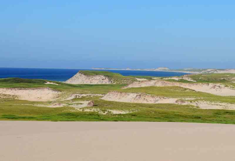
Because of its location and makeup, Sable Island is constantly changing shape, which means charts of the area quickly become out of date. Ocean storms are frequent, and while winds and waves try to tear the island apart by constantly shifting the sand dunes, the island’s other predominant feature, marram grass, helps to hold it together. Nearly half of Sable is grassland, where the roots grow down two or three feet, and there is a wide variety of other vegetation, including cranberries and blueberries, that is well adapted to the island’s harsh environment.
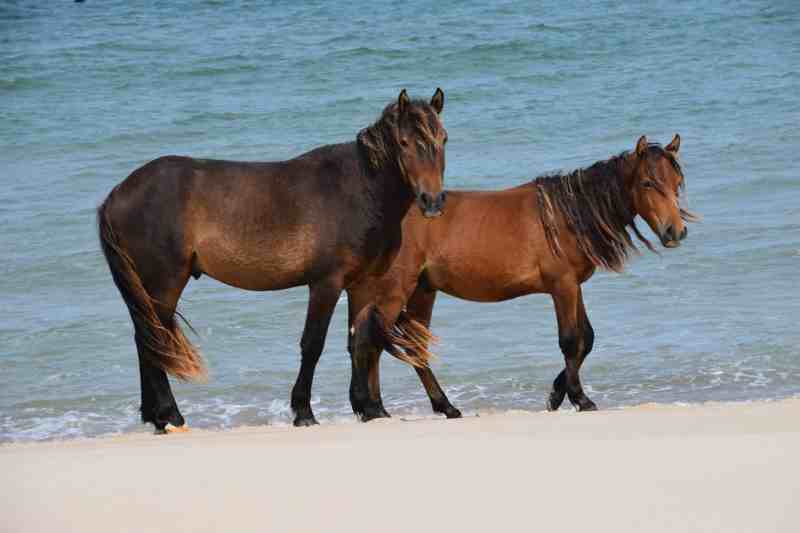
There is also abundant life on the island. Horses were introduced in the early 1800s, either following a shipwreck or to serve intrepid settlers, depending on whom you ask. Today around 500 horses roam the land. They are small in size but can subsist on grass and the fresh water they find. Many of them have developed wide hooves that help them walk through the sand — the same grit that also grinds down their teeth, making it hard for older horses to eat. They seemed to live in family groups, and I was told that during the cold winter months, the herds huddle together for long periods of time between the sand dunes.
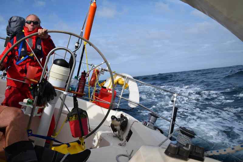
Getting to Sable Island is hard work. Bill Barton, along with two of his longtime sailing friends, David Martz and Carl Doane, spent the early part of the summer preparing for the expedition. Bill owns a Sabre 36 named Tazzarin, after a king in children’s literature. In addition to the Peabody Museum’s Dan Finamore, award-winning cameraman Mike Audick was on board. With six of us in all, Tazzarin was fully loaded for the trip.
Our destination lay 180 miles southeast of Halifax. We left on a clear, cool morning. As luck would have it, we had a southeasterly breeze on the nose, and it continued to build toward 20 knots as the day progressed. About 60 miles out, I started feeling some abdominal discomfort after steering for an hour. I went below, but the pain increased dramatically. While I would prefer not to write about a health issue, there are some valuable lessons that we learned through this unscheduled ordeal.
When the pain became unbearable, Bill called a doctor in the States for advice and soon found a clinic east of Halifax, at Sheet Harbour. I took a heavy dose of ibuprofen and Tylenol and tried to make the best of it. It was a long four-hour sail to a wharf where Canadian medics were waiting to whisk me off to the five-room clinic. As it turned out, I had a kidney stone (the first in my life). It passed that night, and we were on our way the next morning. The lessons I learned that day are that you should always be sure you can reach a doctor, even at sea, and that it is better to head for shore when you have a serious health problem rather than try to tough it out. I was sorry for causing an 18-hour delay, but we were all happy to be back at sea, even if the wind was now blowing over 25 knots — and still on the nose.
The 132-mile voyage from Sheet Harbour was businesslike and routine. There was a purpose to our mission, and we all looked forward to arriving at Sable. As the watches passed, we rotated steering, talked, and even welcomed an osprey aboard for a few hours. The poor bird looked extremely tired. He made many attempts to land on the top of the mast, and unfortunately took out the masthead fly in the process. Eventually he had his rest in the cockpit, next to the helmsman. Then, when the osprey revived, he hopped over the side. He struggled to take off, but finally got airborne with great effort and was on his way.
It was quite a relief to finally sail under Sable’s lee shore. We arrived after dark and waited for sunrise to make our landing. A clear sky greeted us the next morning as we loaded up one of our two inflatable dinghies and headed for the island. Parks Canada station manager Aaron Carpenter was on the beach waiting for us. The waves were small, and it was an easy landing. Sable has no natural harbor, so we were at the mercy of the weather and surf. Had the surf been up, we would not have been able to land.
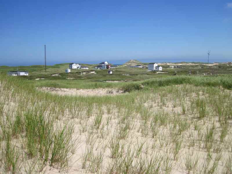
Over the next three days, we hiked everywhere. There are no trees on Sable Island nor any cover to escape from the sun. In the 1940s, Canada built several buildings to house meteorologists and lifesaving personnel. Four of us were allowed to stay in one of the rustic cabins; the other two stayed on the boat at night.
Dan and Bill worked with Parks Canada’s senior archaeologist, Charles Burke, over the next few days. They spent dawn to dusk exploring and recording the many cultural items they found in their travels. It was amazing how much material was scattered around the island; the Canadians do not gather any of it. Jonathan Sheppard, the Sable Island park manager, told me that the cultural material gives researchers many clues about the rich tapestry of attempted settlements and shipwrecks.
As a museum curator, Dan seemed mighty happy to find a treasure trove of artifacts, which he estimated would take months to catalog thoroughly. Part of our agreement in gaining permission to land on Sable was that we provide a written report on Dan and Bill’s findings. Among the intriguing things we discovered was an old mooring buoy or channel marker. It was rusted and shaped like an onion. Dan estimated that it was from the late 1800s. We did not touch any of the artifacts.
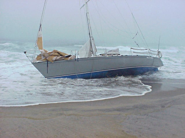
Surprisingly, there was minimal evidence of shipwrecks, even though many stories of ships going down are well documented. We did find the remains of one ship sticking out of the sea, and you could see the outline of a broken hull under the water. We learned that the sand swallows up a vessel quickly. In 1999, a yacht named Merrimac sailed up on the beach and was quickly devoured by the sand. Now 16 years later, we spotted her bulkhead and some rigging about 200 yards from the ocean. It was amazing to see how the position of the beach had changed in such a short time.
Among Sable Island’s many tales of misfortune is the one involving the fishing vessel Andrea Gail, which became famous in the book and film The Perfect Storm. The ill-fated vessel made her last communications east of Sable; the only evidence of her loss was her EPIRB and some fishing gear, which were found on the island’s beach. In 1912, the steamship RMS Carpathia, which had rescued the survivors of Titanic, relayed its reports about the sinking along with a list of survivors through the Marconi wireless station on the island.
With shoal areas extending up to a dozen miles from Sable’s opposite ends, one can imagine just how dangerous these waters were before reliable electronic navigational aids. But one man’s peril may be another’s opportunity, and many people once ventured out to Sable to take advantage of the shipwrecks. There was perceived wealth to be gained by salvaging the cargo that washed ashore, and there are many stories of piracy and theft from this era. Some shipwrecked survivors were marooned for years before being rescued. Sheppard pointed out that there were also tales of valor. “‘Resilience’ is a word that describes many of the shipwrecks,” he said. “There were many crews that rebuilt their vessels. The stories of the quest for survival are inspiring.”
Thanks to LORAN and, later, GPS, shipwrecks are mostly a thing of the past. The lighthouses are no longer in operation. But even with modern aids to navigation, Sable Island demands caution when sailing near its shores. The waters surrounding the island are the foggiest place on the Canadian coast thanks to the extreme difference in water temperature on either side. To the north, the cold Labrador Current flows southwest. This chilled water arrives from Newfoundland and Baffin Bay. Yet not far to the south of Sable, the warm, fast-moving Gulf Stream flows northeast.
It is never too warm or cold on Sable Island, though hurricanes there have the greatest impact of anywhere on the Canadian coast. Monster storms have a huge effect on the topography of the land. Marram grass might grow for decades on a particular part of the island, only to be completely blown out by a storm. It can take many years for vegetation to regrow.
On the east end of the island, Mike Audick and I filmed our climb up Bald Dune. This desolate spot is 120 feet above sea level and a 6-mile hike from Main Station. We felt a great sense of achievement in being able to sit atop that pile of sand. A few times during our visit, I was able to rest quietly and just look at the landscape and the sea. There were no ships on the horizon, no Internet, no cellphones to break the silence. There were no footprints in any direction. A few horses occasionally strolled by, and it was fascinating to watch the seals on the beach. These moments made me wonder what the barrier islands on the East Coast of the United States were like before any development.
I grew up on Barnegat Bay, New Jersey, a body of water formed by barrier islands. Superstorm Sandy in 2012 was a brutal reminder of how fragile the beaches are. A few months after the storm, I filmed the bay and islands from a helicopter. It was horrifying to see so many ruined buildings. That image was in my head as I sat on a dune looking at unspoiled Sable Island. I was at peace during my respite there. The fast-paced world was at bay, and at night the stars were brilliant and infinite.
During one period of rest, Finamore asked me if I could envision an America’s Cup race taking place off Sable. That day the sky was clear and the wind was blowing 18 knots. It was perfect for sailing. While it would take considerable infrastructure to host an America’s Cup in that inhospitable setting, I could see a fleet of 80 Lasers racing there. I figured the sailors could stay in tents on the beach. It would be rustic, but great fun. (Of course, the sharks lurking nearby might be an issue.)
There are several hundred thousand seals living around Sable Island. Sheppard said their population is a good indicator of what else is living in the surrounding waters. Grey and harbor seals are the two most prevalent species. The male greys can weigh up to 650 pounds. There are other types of seals as well. Walruses could be found on Sable centuries ago, until they were hunted to extinction. Just past the surf line, 18 types of sharks lurk, waiting for a lone seal to swim out; the predators tend to avoid larger groups. During our visit we found three seals on the beach with huge chunks of their bodies missing. It was awful to see them in pain from the shark attacks, but there was nothing we could do to help them. We were reminded by the Canadians that this was part of the cycle of life. In the winter the seals move all over the island. We found many seal skeletons well inland. There was considerable plant growth around these areas. Sheppard said that this kind of ecological activity helps keep Sable Island stable.
We spotted many birds. One of the more prevalent species is the Ipswich sparrow, which lives on the Eastern U.S. Seaboard during the winter. Sable Island is the birds’ sole nesting place, and they must fly over 400 miles to reach it each breeding season. Bill Barton told us that there are 16 species of birds that nest on Sable, along with many transient visitors.
With our crew on the island, the population soared to 18. In addition to us, there were four Parks Canada personnel, several researchers, and four college students who were spending their summer studying the genetics of the horses through their dung.
On the third day of our visit, we learned that a strong cold front was coming in from the northwest. “Oh boy,” I thought, “another upwind blow for the sail back to Halifax.” At sunset we loaded Tazzarin for our voyage to the mainland. David Martz took on the job of hoisting the anchor, which was well dug in after three days. It was windy, but we made it back on one tack. Finamore spent considerable time at the helm. I enjoyed watching him improve his steering technique. The secret, he told me, was to anticipate the waves two to three swells ahead of the boat.
It’s hard to know if the ocean will someday swallow Sable Island, or if the wind will blow it off the continental shelf. Sheppard said Parks Canada is working on a management plan to find ways to preserve the island, which may allow more visitors (with a light footprint) in the future.
On my next transatlantic flight, I expect that I will once again search for Sable Island. When I see it, I will surely smile, knowing that, at least once, I got to explore the mysterious, magical spit of sand.
Gary Jobson is a winning America’s Cup tactician, writer, filmmaker and CW editor-at-large.


