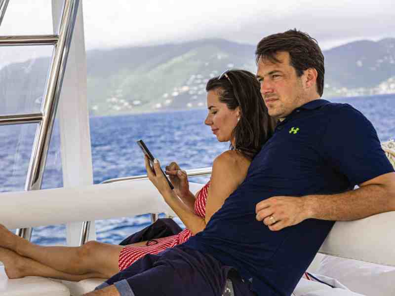
When it comes time for a sailing vacation or even a delivery trip on a friend’s boat, one of the great things about smartphones and tablets is that you can pack a ton of useful apps into a tiny device. Even better, they allow you to effectively bring your own nav system along on a boat whose chart plotter or choice of cartography might prove difficult to use. But calling it good with navigation assistance would be short-selling your phone or tablet. Here’s a look at some apps, broken down by category, that stand ready to help make your next getaway by sail an even better experience.
Accommodations
If you’re a veteran cruiser, you’re likely familiar with ActiveCaptain, which is a Garmin-owned app that connects countless users with information on almost 18,000 marinas, just shy of 13,000 anchorages, and more than 146,000 reviews of different marine-related businesses around the world. The free app is compatible with Android and iOS platforms; gives access to points-of-interest information such as fuel-dock prices or marina reviews, as well as location and contact information; and includes access to the ActiveCaptain Community, which delivers user-written feedback and reviews on water-related businesses and experiences. Community information can be displayed as a layer atop Navionics cartography (another Garmin-owned brand; see below), giving you additional navigation and decision-making information when plying unfamiliar waters.
Scoring a night’s marina berth or dock space can sometimes be tricky. This is where Snag-a-Slip can be a highly valued virtual crewmember. The app is designed to help connect boaters with marinas and privately owned slips in North America and the Caribbean. Users input their particulars such as boat length, beam, draft and preferred dates, and then the app helps filter the options. Payments are done via credit card, and the app, which doesn’t charge a booking fee, guarantees to match a marina’s advertised rates. The app can also put cruisers in direct contact with the owners of private slips. Snag-a-Slip works on both Android and iOS platforms.
Go Fish
Fishbrain is a free app that works on both Android and iOS platforms, allowing anglers to record their catches and (optionally) share their location information. It also features its Species Recognition tool, which helps visiting cruisers ID their prizes. The app includes information on where the fish are biting and what kind of bait is attracting strikes, and its Fishing Forecast employs user data to help you plan your day. Fishbrain purportedly boasts more than 10 million users and features a social side that allows you to connect with other anglers. A paid version of the app—dubbed Fishbrain Pro—includes access to all shared catch locations, private-group conversations, and crowdsourced contour information via C-Map social maps.
Keep in Touch
While not a boating-specific piece of software, WhatsApp allows users to make phone and video calls and send texts using a smartphone’s internet connection rather than local cellular towers. Provided you have a way of accessing a Wi-Fi network, say, at a marina, this can save significant money and eliminates the hassle of dealing with SIM cards. WhatsApp employs end-to-end encryption, which ensures that the only people you call or text can hear or read what you’ve sent. This is particularly useful when using unsecured marina hotspots. Additionally, Android and iOS users can send photos, videos and voice memos, as well as documents (up to 100MB in size) using a few screen taps, and the app also supports group messaging (up to 256 users per communication), making it easy to securely keep in touch with family and friends.
Take a Hike
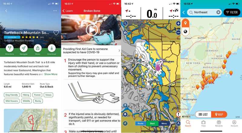
Many sailors, myself included, look forward to heading ashore for a hike as soon as the anchor is made fast. AllTrails leverages its community of 20 million users to give you at-a-tap access to more than 100,000 trails, including directions to trailheads, user-submitted hike reviews, and crowdsourced photos. Hikers can access relevant maps and use their phone’s GPS to avoid getting lost (not that that would ever happen to an intrepid mariner), track their stats, and set filters to find, say, dog- or kid-friendly hikes. Alternatively, adventurers can opt for AllTrails Pro, which allows them to download maps for offline use, receive off-route notifications, and enjoy real-time map overlays.
Long trusted by outdoor enthusiasts (including myself), Gaia GPS turns your Android or Apple phone into a chart plotter for terrestrial adventures. The app is loaded with handy features, including its Discover tab, which helps visiting sailors connect with great nearby hikes. But its best feature is its ability to leverage your phone’s GPS to provide location information atop pre-loaded topographical maps, even when cellular service isn’t available. Hikers can access up-to-date weather forecasts via the app, and they can measure distance, altitude and elevation change with a few simple screen taps. The app offers three membership levels—free, member and premium member—that unlock different levels of downloadable topo and satellite maps.
Stay Well
No one likes to dwell on thoughts of medical emergencies, especially while off sailing, but the reality is that things can, and do, go pear-shaped. First Aid: American Red Cross, which is available for Android and iOS platforms, gives step-by-step instructions for navigating a menu of medical emergencies. The app includes pre-loaded content that can be accessed offline, and—for times when cellular or Wi-Fi connectivity exists—it also includes a handy hospital finder. The app is integrated with 911 services, and it includes informative videos that can help the crew brush up on their first-aid skills, as well as quizzes that help cement this knowledge base.
There’s more help available as well. If you or another crewmember falls ill, WebMD can help diagnosis the problem. The app’s Symptom Checker allows sailors to select their ailments and learn about care options, and its Doctor Directory can be a great resource for finding (and making appointments with) doctors and specialists. Users can leverage the app’s Medication Reminders to help them take their daily meds, even when time-zone shifts or vacation brain is at play, and its Drug Interaction Checker helps ensure that users don’t accidentally serve themselves an unsafe cocktail of prescription medications. WebMD works with Android and Apple devices, and it can be a useful source of second opinions if you’re cruising in areas where language barriers exist.
The Great Outdoors
One of the coolest aspects of chartering in new waters is the opportunity to identify unfamiliar birds. The trouble, of course, is identifying unknown species. Enter iBird Pro, a paid app that includes a deep database of all birds in North America, the United Kingdom, Ireland and Palau, as well as its Photo Sleuth feature, which leverages the app’s onboard artificial intelligence to match user-captured bird images with their identities. The app delivers detailed illustrations of each species in its database, and its search engine allows birders to cross-reference characteristics such as their GPS location or a bird’s song type with the app’s database to identify nearby flyers. Moreover, the app also contains more than 4,000 bird songs, and its Birds Around Me feature lists usual suspects using your device’s location information.
Aside from staring at campfires, few activities are more hardwired into the human brain than stargazing. Star Walk 2 delivers a real-time virtual map of the night sky. Android and Apple mobile-device users can just point their phone at the sky, and the app leverages gyroscope and GPS information to match stars, planets, comets and constellations with its real-time map. The paid app’s Visible Tonight and What’s New features keep stargazers appraised of upcoming events in time to enjoy them with friends and family. Users can also leverage the app’s clock-face icon to virtually see the sky at different dates and times (past, present and future), and they can also find—and learn more about—deep-sky objects such as meteor showers. Additionally, the app can be used to learn more about planets, or even to track down the International Space Station.
Among sailors, it’s fair to say that whales rank highest on the list of charismatic megafauna species, even if it’s not always so easy to identify them by a cursory glimpse of a fin or a tail vanishing beneath the brine. WhaleGuide can help by offering detailed descriptions and some 850 photos of 68 species of whales and dolphins; in-app purchases can unlock an additional 560 images and 80-plus video clips. The for-pay app, which is available for Android and Apple platforms, offers descriptions of each species’ behavior, typical diving performances, regional habitats and usual hotspots (across 100 countries), as well as fun facts and figures. WhaleGuide’s Finder feature helps users identify whales using their device’s GPS coordinates and a few observed details, and it can also be used as a pre-cruise primer on what one might hope to encounter while sailing.
Map Time
Situational awareness ranks high on C-Map: Boating’s priority list, and the app is designed to give users at-a-glance info about what matters now. The app delivers an uncluttered appearance, and it auto-adjusts its color palette and contrast to ensure that its cartography, which is sourced from official hydrological offices and constantly updated, is readable. The app is free, but users who are cruising outside cellular coverage will want to upgrade to the app’s premium version so that they can download and store charts on their mobile device. The app’s Autorouting feature makes it easy to chart a course to Port B, and its Tracks feature leaves a trail of electronic breadcrumbs astern, making it simple to retrace your voyage. AIS targets (from within a 54-nautical-mile radius) can be overlaid atop chart views, and points of interest and weather information can also be accessed from within the app. Users can personalize their charts with images, notes and their choice of measurement units, and they can share their favorite (or recently discovered) anchorages with friends. It’s available for Android and iOS platforms.
On a personal note, I’ve long trusted Navionics to serve as my personal nav station, both for racing and cruising. The Navionics Boating app is available for Android and Apple devices, and gives mariners access to a wealth of Navionics vector cartography and unadulterated NOAA charts. Creating routes is a matter of tapping the screen and selecting waypoints, and the app’s crosshairs function makes it easy to explore chart features or add points of interest. Users can pair their mobile device with a Wi-Fi-enabled AIS receiver (or a chart plotter that’s networked to an AIS receiver) to overlap AIS targets atop cartography. ActiveCaptain Community information (see above) can also be accessed through the app. The Community Edits feature gives users access to points of interest. The app also provides angling information, such as its SonarChart feature, but it’s the app’s dock-to-dock Autorouting feature that helps remove navigational guesswork. Additional features include access to weather and tide information; Plotter Sync, which wirelessly transfers chart layers, routes, and waypoints between mobile devices and B&G or Raymarine chart plotters; and Connections, which helps you track your boating buddies.
To be clear, the MarineTraffic app isn’t a replacement for AIS information or an actual AIS receiver/transceiver, nor should it be relied upon to determine safe crossing distances, but it does provide information on nearby AIS-equipped vessels. Users can track vessels and glean insight into their arrival and departure information, and the app’s Access Plus 24 feature (which requires an in-app purchase) lets users look for ships and vessels that are far outside their geographic area using satellite AIS information. The app also provides access to some 2.5 million images of ships and points of navigational interest such as lighthouses and harbors, and users can upload their own imagery to this database. Additionally, the app provides wind forecasts and a route-planner function, and its Augmented Reality tool helps sailors identify vessels and points of interest using the device’s camera.
Play It Safe
Wise mariners set GPS-based anchor alarms so that they can deal with anchor-dragging hiccups before they devolve into full-blown problems, but this can sometimes be tricky on an unfamiliar chart plotter. Android users can stay a step ahead of the odds with Anchor Watch, which lets a skipper create a GPS-based geofence. Should the boat start to drift beyond the scope of its virtual anchor rode, the app trips a customizable audible alarm on the phone; the app’s professional version can also send email and instant-message alerts. Likewise, the app will also trip an alarm if the phone loses GPS reception. Two cautionary notes: The phone needs to be placed in an area with strong GPS reception (the app displays its real-time signal strength), and apps that constantly monitor a phone’s GPS location need to be fed a steady diet of DC power, so plan accordingly.
Named simply Coast Guard, the US Coast Guard’s app is one that all mariners should have handy, both for domestic charter trips and for cruising their home waters. The Coast Guard’s app allows Android and Apple users to create float plans; locate NOAA buoys; report navigational hazards, pollution or suspicious behavior; or just brush up on the rules of the road. Sailors can also learn about local boating regulations from state to state, cross-reference their onboard safety kit with the USCG’s checklist, get weather information from nearby NOAA buoys, and learn more about the safety regulations. The app also allows sailors to ping the USCG for emergency help via its Emergency Assistance button.
Two More Handy Apps
Money might enable overseas travel, but it can also pose headaches when exchange rates and money transfers are required. Xe Currency & Money Transfers can help with both of these issues by letting travelers check current rates of more than 130 currencies and track the transfer of their monies. Users can easily add recipients, and they can also set the app to alert them of currency fluctuations. Additionally, the app provides charts showing 10 years’ worth of rate history, which can be useful when choosing when to convert US dollars.
One good rule of the road for mariners on vacation or simply sailing from here to there involves not paying through the nose for cellular data. This is where WiFi Finder shines. The app, which works on both Android and iOS devices, allows you to research fast Wi-Fi hotspots (both local and global), and its offline functionality allows you to download this information as a map for later use. Users can filter hotspots by venue, such as hotels, cafes, etc., and the app also works in offline mode, which can further diminish your reliance on overseas cellular data.
David Schmidt is CW’s electronics editor.
Apps-at-a-Glance
ActiveCaptain: garmin .com; free, with in-app purchases
AllTrails: alltrails.com; free or $30 per year for the professional version
Anchor Watch: peckish-sloth.com; from $6
C-Map: Boating: c-map.com; free, with in-app purchases
First Aid: American Red Cross: redcross.org; free
Fishbrain: fishbrain.com; free, with in-app purchases
Gaia GPS: gaiagps.com; free, with in-app purchases
iBird Pro: ibird.com; $15
MarineTraffic: marinetraffic.com; free, with in-app purchases
Navionics: navionics.com; free, with in-app purchases
Snag-a-Slip: snagaslip.com; free
Star Walk 2: starwalk.space/en; from $3
Coast Guard: uscgboating.org; free
WebMD: webmd.com; free
WhaleGuide: ocean-pix.de; $10
WhatsApp: whatsapp.com; free
WiFi Finder: etrality.com; $5 for three months or $10 per year
Xe Currency & Money Transfers: xe.com; free


