You never know when you arrive in a new harbor what life will bring you there. A planned stop of a couple of days in a place that was, in our minds, simply going to be a stepping stone to the seemingly more fascinating island of Guanaja, suddenly unfolds to become a full destination itself.
We headed to Barbareta as much for relief from the no-see-ums and sand flies persecuting us at Port Royale, as we did for the island. The bites theyd inflicted had given each of us constellations of red spots that had the disagreeable characteristic of becoming even more itchy on day two, and twice again as itchy on day three. So, despite a slightly overcast day, not ideal for seeing the reef, we traced our incoming track and fled screaming from the place.
| | The promise of a new day on a new island* * *| But, where to go? Wed scanned guide books for information about the bights and islands nearby, trying to read between the lines for clues as to the gluttony of the insect population our new top priority. “Do plan a beach picnic,” one guide noted cheerily, “but dont forget to pack a little Cactus Juice!”referring to the anti-bug elixir the locals use. Such an admonition, weve learned the hard way, usually means the place is a torture chamber of flying teeth. Wed be giving these spots a miss.
Wed heard Barbareta was pretty and virtually uninhabited, although the guide book promised nothing special. Other cruisers wed met had stopped there for a day or so, then moved on west to Roatan, or east to Guanaja. Theyd liked it well enough, but no one sang arias of praise or seemed to have stayed very long. We thought wed do the same, which goes to show that you need to take everyones advice with a grain of salt, especially if you dont know what lights their fires.
| | Douglas, in his element* * *| Weve been here almost three weeks now, weathered three northers hereone piddling, one middle of the road, and one ferociousfeasted on fish and conch caught by Douglas, or by our friend Cade on _Sand Dollar_, or by some of the fishermen from St. Helene who dive these reefs. Weve kicked back and read a pile of books, hiked around the hills, done a lot of snorkeling, accomplished a few chores on _Ithaka_, and so far we count Barbareta as one of the most beautiful places in the entire Bay of Islands.
We arrived in poor light; the clouds obscured the sun and prevented us from seeing the reef through the water. But this wasnt too big a problem, because we had good coordinates to enter the wide opening, and we could see the surf breaking, which confirmed our position. Barbareta loomed larger and larger aheadjust under three miles long, and a third of a mile wide, the highest of its three major hills rising to about 500 feet. But when we approached the most protected cove of the island, we couldnt see the coral heads that our chart showed as standing between us and the empty anchorage. We poked in as slowly as we could, until we were in 12 feet near Pelican Rock, and dropped the hook. Douglas dove on the anchor, and swam the radius of our scope. Satisfied that there were no dangers, we settled in for the night and watched pitch darkness fall all around us; even the stars were shielded by the clouds. Our anchor light was the only light of any kind to be seen.
| | Many places around Barbareta, we found the bottom to be a carpet of pretty corals* * *| The next morning, as soon as the sun came out from behind the clouds and the reefs, shoal, and coral heads were more obvious, we pulled up our anchor, and motored further inside the protection of the reef in Pascual Bight, closer to the shelter of the islands tall green flanks.
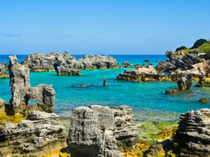
The first couple days, we had the pretty anchorage to ourselves. Under us was 22 feet of inviting turquoise water and good holding. Ashore, horses ran free along the beach; giant iguanas sunned themselves everywhere; There was lush forest, beaches and reefs to explore all around the island, and coconut palms nodding in the wind. And, ecstasy, not a bug to be found, as long as we went ashore in a breeze, during mid-day. How, we wondered, could this spot be described as a mere stepping stone? We loved it.
One day, a singlehander named Steve arrived on Tulak, a dark green Bristol 32. We went over and got acquainted. Steve and Douglas went out snorkeling the nearby reefs hunting for fish, we traded books, and we pondered the weather, which was blindingly bright and clear then, but about to deteriorate. The 72-hour weather forecast warned of a cold front coming our way.
| | Tulak safe at anchor* * *|
One afternoon, Steve and Douglas rearranged our Monitor’s self-steering lines so we could use it with our 36-inch extruded aluminum stub tiller, which fits into our aft-hung rudder—a more responsive system (fewer blocks and turns) than on the large wheel. As a singlehander, Steve has learned to tweak his Monitor with great precision, and we welcomed the advice. Just then, a blue sloop sailed into the cove. We stopped our fiddling to admire their pluck to sail in through the cut in the reef under headsail and main, until it dawned on us that they’d stopped cold. Steve jumped in the dinghy and headed over to help them out—by now we knew where the shallows were, and it looked like they’d located one the hard way. After a bit, he came back to Ithaka, smiling.
“Ill be damned,” he said. “Theyre not aground at all. They anchored from the stern under full sail. Said they like it when the breeze comes down the companionway.” These kinds of displays usually cause Douglas and me to wonder about all the things we dont know much about in sailing technique. Anchoring backwards is just another one to add to the list.
That night, the cold front hit. It had been forecast to be moderate, to pack winds of 20 to 25 knots, to come from the northeast, and to arrive on Saturday afternoon. On all counts, the forecasts were wrong.
The wind began picking up at dusk Friday—earlier than we expected, but alright, we’d deal with it. First it hit 20, then 25. By 10 p.m. it was 35, but not so much from the north-northeast as just plain west-southwest, which was far from ideal as this exposed us to a fetch of about five miles. We put the radar on, and found Tulak located off to our port bow, the outline of the beach off to starboard, and the blue boat not far behind us. So far, all was well. We marked ourselves on the radar’s range. We were holding steady. By midnight the wind had climbed to 40. Then, a tense moment: Tulak seemed in a different position than he was the last time we’d checked, and the blue boat had disappeared off our radar range altogether. We shined our high-power flashlight on Tulak, and saw that Steve had put out a second anchor and pulled himself forward and more to starboard. That explained that. But something was very wrong with the position of the blue boat.
| | When the wind calmed down, the rains started* * *| Outside, we could see a pin-prick of light astern in the distance, but well outside the cove now. It had to be the blue boat, in a dramatically different position, about a quarter mile from where it had been before. Could they be asleep and not know they were dragging? We started calling them on the VHF, but got no response. When we increased the range of our radar screen, and watched for a while, we could see theyd stopped moving, but by then they were out in the channel, and fully exposed. By 1 a.m. the gale had reached 45 steady, gusting much higherand it was all coming from the west-northwest.
On the VHF, we also could hear clearly a chilling conversation between a cruising boat and a tanker somewhere offshore, north of us. A French womans voice kept giving her position, then kept repeating, “Now can you see me? Please, now can you see me?” The Spanish-speaking man on the bridge of the ship kept answering, “No, I cannot!” Finally, in 50+ knots of wind, the ship and sailboat passed one another, with the tanker never seeing the sailboat on their radar and the womans voice saying again and again. “You are just off my port bow. Please, try again to see me.”
Douglas and I took turns on anchor watch, but neither of us really got any sleep that night. By first light, things had calmed down a little, to 30 knots (everything seems more tolerable in daylight), and with the binoculars we could see the blue boat off in the far distance, hobby-horsing wildly over the shoals, with her square stern still blunt into the wind. We called them repeatedly on the VHF, as did Steve, but got no answer. Steve said Tulak had touched the shoal rimming the cove in the night, so he put on his life vest, dinghied out to set a second anchor, and pulled himself into deeper water. He was fine, he said, and agreed with Douglas that it was still too dangerous to go out to the blue boat in our dinghy in these winds and whitecaps.
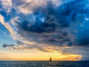
| | Between the cold fronts, the sky displayed a never-ending show of shapes and colors* * *| We tuned into the Northwest Carribean Net at 8 a.m. local time (1400 Zulu) and found lots of action. A boat named _Francesca_ had been caught in the shallow waters of Bahia Escondido, a bay on the north coast of mainland Honduras, and had their windlass and bow pulpit completely torn out of the deck in the wild night. Also, two boats were on the beach at West End, Roatan, an anchorage completely exposed to the west and north. Another was aground off the Cayos Cochinos. Winds in Cay Caulker, Belize, had reached 55 knots, and a catamaran was reported on the reef at Turneffe Island, Belize. None of these boats was lost, but that so many people got into trouble was a testament to just how off base NOAA can be sometimes, how much a mystery the weather remains, and how important it is to err on the side of caution.
Bahia Escondido, where Francesca had gotten in trouble, had been a bay we’d considered when we’d made our run from Guatemala to Honduras last November, but we’d decided to bypass it because it was so shallow and exposed to the northwest. We’d also been advised by other cruisers that it had become notoriously dangerous since Hurricane Mitch: where the guidebooks were listing eight to ten to 12 feet, the bottom in many areas had silted in to six or seven feet. We were lucky to have gotten the update.
By mid-morning, the blue boat motored slowly back into the cove. Yes, they said, theyd dragged out into the channel, where the wind speeds had gotten up to 60 knots, and an engine problem had prevented them from doing anything about it. Their anchor had ended up grabbing, finally, as the water was beginning to shoal at a reef, and thats where theyd weathered the night, with only two feet under them, being thrown around pretty badly. We learned all this as they motored slowly by us looking for a place to reanchor. When they found a spot, once again they dropped their anchor off their stern.
| | Margret and Ulli from Filia* * *| We had two days of strong, cold winds, active enough to create spiraling williwaws, like rushing ghosts, all over our anchorage—a beautiful sight, albeit a little hairy. We pulled out our sweaters and socks, stayed hunkered down, and watched the show. Then things calmed over the next two days, and we were joined in our cove by Cade and Lisa _on Sand Dollar_, and Margret and Ullie on _Filia_, who’d ridden the tail end of all this northwest wind for a sleigh ride from French Harbor and Port Royale. It was great to see these friends again; we’d all been crossing paths and sharing anchorages in Honduras ever since our cruisers’ Christmas party almost two months before. Lisa and Margret brought fresh veggies and fruit for Douglas and me, which was a lovely boost, and which we divided with Steve. I was surprised to realize that we hadn’t been to a market in over three weeks.
Finally, Steve caught a gentle westerly and headed out east for Guanaja in blazing sunshine. Well follow his track eventually, but Barbareta still had a hold on us. Every day, we took the dinghy to some other side of the island, and with our look-bucket (a five gallon plastic paint bucket with a clear plexiglass bottom) scouted out coral beds, and jumped in to explore them. We found beautiful snorkeling, isolated beaches, and the best hunting so far in Honduras. Ashore, the tropical rain forest was shrouded in a mist at the top of the little mountain, and everywhere there were songbirds, herons, egrets, hawks with white wing tips, and yellow-green parrots.
| | Cade and Lisa from Sand Dollar* * *| One day, Lisa came over and helped me make a no-see-um net for _Ithaka_’s cockpit; I’d bought the material, but never could figure out how to make it properly. With Lisa’s imagination and sewing skills, we had it up by the end of the day. Almost every afternoon, a father and son stopped by in their hand-carved cayuco; the old man told us they were from St. Helene, a town on the easternmost tip of Roatan—only about four miles away—and that he’d been fishing around here for 30 years. If we hadn’t caught anything ourselves, we could buy all the fish and lobster we needed for a few dollars.
| | Captain Sherman Archer of French Harbor, well known in the Bay Islands not only as a fisherman but as a boatbuilder.* * *| One evening, the day the second cold front was to pass by, a larger fishing boat entered the cove and anchored nearby. Douglas dinghied over to say hello, and let them know we had 150 feet of chain out. _No problema_. He returned to _Ithaka_ more than two hours later, with a grin from ear to ear, a bag of banana bread made by the captains wife, and an invitation to join the crew of _Flamingo II_ to go fishing for tuna the next day.
The second cold front wasn’t much of an issue, reaching only 25 knots overnight, but by then we knew we were well dug in, and went to bed. Then, flouting the forecast, the front became occluded, stalled out, and churned things up for a couple of days more. Captain Archer brought Flamingo and his dory, Miss French Cay, back into the cove to weather it out.
“I feel like a ride,” he called over when things calmed down. “Wanna take a look at the Pigeons?” We sure did,, jumped in his pretty 37-foot dory, he throttled up her 170-horsepower Yanmar, and we shot out at 25 knots over the light turquoise shallows for a couple of miles to the two postcard-pretty sand cays out on the reef. Then, he spun Miss French Cay around to show us the bearing out through a channel in the reef, which he said he’d transited a million times. “It’s not in your guide book,” he smiled, “but it’s a good one for you.” He told us all about how to read these cold fronts better, about how he built this dory, about his great-grandparents coming over from England, about the market for fish, about how he sells shark fins as a delicacy, and about how much he loves these reefs. “I got everything I need here,” he said, looking around. “I’m a lucky man.”
| | Miss French Cay, Captain Archer’s pride and joy, is a sleek and gorgeous vessel he built himself. She cruises at 20 knots, and maxes out somewhere over 30. “Now a lot of people want one,” he said.* * *|
When we got back to Ithaka—with a bag of fresh tuna from Captain Archer—I whipped up a big batch of chocolate-chip cookies for the crew of Flamingo. The next day after fishing, the captain stopped by to chat for a while, and brought over a filleted grouper.
“Could you use some hot Irish soda bread?” I said. He looked pretty pleased with the idea, and I gave him a warm loaf. This was great; we each did what we could for the other.
So thats how our days have unfolded on Barbareta: projects on the boat when the weather was bad, snorkeling and beach-combing when it was brilliant, and reading and cooking and hanging out in between times. At night, we had skies so clear that we could see shooting stars, the wide swath of the Milky Way, and even the space station passing overhead. We never felt the need to hoist our dinghy up at night; except for the weather, weve been completely safe. Many times, Ive been reminded here how glad I am that were traveling slow enough to let places like this unfold to us in their own time.
| | The crew of Flamingo killed a shark the night before, and kept the fins. “Hammerheads are our biggest problem,” Captain Archer told us. “They’re always eating up our profit before we can reel it in.”* * *| On one of our last days at Barbareta, we dinghied ashore, and went for a hike into the hills, hoping to come across the horses we’d seen galloping on the beach. We found four of them, grazing in a clearing, as well as beautiful views down to _Ithaka_ from the green hills, and of the Pigeons out on the horizon, and of _Flamingo_ heading out that distant cut into deep water. We’d hear much later, that the owner of the massive island and it’s sole inhabitant, a man named Pepper, likes to patrol his island armed with his AK-47, and “doesn’t like to be surprised.” Mercifully, we never saw him.
What we did see was a sight a sailor never tires ofour boat resting serenely in the secluded cove below us, out in the middle of a beautiful nowhere. Looking down on her, it made me remember how much it took to get there, and how far, in every way, we are from home.
[e-mail the Bernons](mailto: Ithaka@cruisingworld.com)

