Just as laden honeybees make a determined beeline for home, sailors sometimes must hold an arrow-straight course. In the open ocean, cruisers tend to set the autopilot, adjust the sails and beeline on the shortest path possible. Why add distance by straying from the rhumb line?
But the shortest distance often isn’t the quickest, or the most comfortable, or the best sailing. To explain why, let’s look at the common cuckoo migration and a few human examples of what technology has made easy to overlook.
A common cuckoo looks like a sleek pigeon with transverse racing stripes. It has roughly the heft of a small onion as it departs in late summer from Europe and Asia to winter in Africa. Cuckoos migrate up to 18,000 miles each way over ocean, desert and mountains—by aligning with favorable winds. That’s how they can fly incredible distances.
Just as the cuckoos learned to work with the wind, so did sailors from millennia ago. Austronesian voyagers in sailing canoes discovered islands across the Pacific and Indian Oceans. Through trial and tragedy, they learned to use seasonal shifts in wind direction and intensity to reach new destinations and return.
Similar understanding was still being refined in the early 15th century as Portuguese mariners sailed south along the west coast of Africa. The outbound journey in northeast trades was easy. Returning home was not. Over decades, a counterintuitive pattern emerged: to sail north to Portugal, first sail west, and then slowly climb in latitude to reach westerlies that could carry them home. These roundabout returns often took ships as far as the Azores. The concept became known as volta do mar, the “turn of the sea.”
During the following centuries, sailors identified wind and current patterns across the Atlantic and eventually around the Earth. Global voyages flourished, the world shrank and the wealth of a few nations boomed by knowing how to harness wind and current.
In the mid-19th century, an American naval officer, Matthew Fontaine Maury, made another leap in routing strategies. Confined ashore after an injury, he studied ships’ logbooks with unusual curiosity. He compared individual ship routes and passage times, and found patterns leading to a vast upgrade in routing strategies. His 1855 book, The Physical Geography of the Sea, synthesized thousands of observations into usable charts and routing guidance. This made voyages safer and faster, shortening passage times by days and weeks.
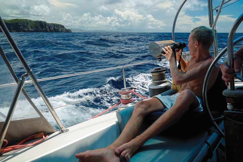
Today, with a few keystrokes, a sailor near land or far offshore can access detailed forecasts as well as observed and photographed oceanographic data. Knowledge accumulated from thousands of years of exploration, coupled with modern tech, has us voyaging with less risk and hardship.
The contribution of modern tech makes cruising easier, but not always better. I use, teach and promote routing software for better passages. Used well, it’s like having an America’s Cup tactician on the crew.
But software doesn’t grasp the full context, and it will never know misery like a crew being seasick from an unexpected sea state. Routing software helps us align to wind shifts like a tactician on a racecourse. It doesn’t account for subsequent days on a multileg journey to a more distant destination. We also need to think like a navigator with the long game in mind.
The Thorny Path
Carleton Mitchell coined the term “The Thorny Path” in the 1950s to describe the stretch of water from the southern Bahamas to the eastern Caribbean. It’s thorny because sailing east into prevailing trade winds and their wind waves is slow and uncomfortable. Bashing upwind can be tolerable for short distances. An 800-mile upwind slog to the eastern Caribbean is brutal on the crew and boat.
But we have a saying aboard Totem: “mio.” It means “misery is optional.” There is a well-established way to remove those thorns.
From mid-November through mid-May, low-pressure systems move eastward off North America and across the Atlantic. With good forecasting tools, sailors can identify when an approaching low and its associated cold front temporarily disrupt the easterly trades. These disruptions create windows that avoid prolonged upwind bashing, lasting anywhere from a few hours to several days. Be patient and move when the wind is favorable.
Executing this usually requires several shorter legs. The tactician looks for wind shifts and current advantages on each leg. The navigator considers how all the legs fit together. Both roles matter.
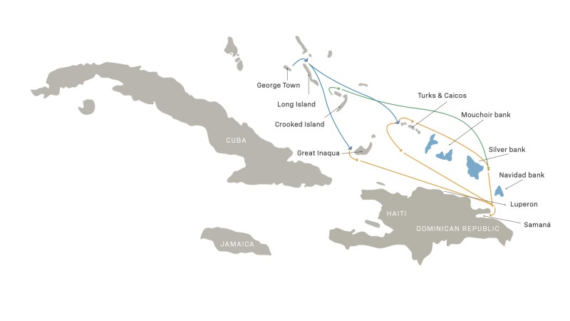
Imagine starting in George Town, Bahamas, with a forecast showing a two-day disruption window. After 48 hours of mild conditions, trade winds will reform. That’s enough time to go over Long Island, then turn southeast toward Crooked Island and reach a decision point: Should leg one go east of Crooked and Acklins Islands toward Turks and Caicos, or west to Great Inagua, shaving roughly 20 nautical miles?
Both options are appealing for leg two. From Great Inagua, first pass under the island. Then, take an east-southeast course skirting the Dominican Republic coast to the crab claw, Cape Samana, with stops possible at Luperon, Ocean World or around the cape into Samana.
Alternatively, start leg two 55 nautical miles farther north in Turks and Caicos with options to go over or under the small island nation. The low road clears the reefs and aims southeast to the crab claw. The high road is more nuanced, needing to thread by Mouchoir, Silver or Navidad Banks.
With a good trade-wind disruption, does the choice matter? Well, not all disruptions are created equal. They are frequent across the Bahamas because of winter cold fronts, but less frequent and shorter-lived 250 miles south near the Dominican Republic. That fact alone tilts leg one toward Turks and Caicos.
And there is another, larger factor. Hispaniola stretches nearly 350 miles and rises above 10,000 feet. Daily heating and cooling generate localized winds. Katabatic wind spills off the mountains and convection makes squalls. Winds around Hispaniola are often not fully disrupted or easy easting. Another challenge is a roughly 1 knot west-setting current commonly between Turks and Caicos and the Dominican Republic. And while Great Inagua with its pink flamingos is a fine destination, it sets up tougher conditions for the remaining miles to the Eastern Caribbean.
So, Turks and Caicos it is, but high road or low? In my experience routing boats toward the Dominican Republic and Puerto Rico, the high road over Turks and Caicos is more often the better choice. Going under the banks demands a longer disruption window because of angles. Once clear of the reefs around Turks and Caicos, the course to Cape Samana is about 125 degrees. In easterly trades from 090 degrees, the true wind angle is roughly 30 degrees, and apparent wind angle is worse, violating the misery-is-optional rule.
The high road looks less direct but is roughly the same distance, with one key advantage. It begins on an easterly course, often until past Silver Bank and then a turn south. When the trades reform, a nearly due-south run of about 80 miles to the crab claw delivers excellent sailing.
I recently routed cruisers from Crooked Island toward Samana using the high road over Turks and Caicos. The forecast showed that the cold front disruption wasn’t quite long enough to pass Silver Bank and turn south before the trades fired up. I suggested that they sail close to due east to get separation from Turks and Caicos and the banks.
Underway, I monitored their tracker and saw that they weren’t getting separation as suggested. The urge to follow the shortest path is strong. I nudged them again, and they corrected course.
As they passed well north of Turks, north wind began to clock slowly on its way to becoming easterly. With each incremental change, they adjusted their course from east to be progressively more to the south, maintaining a lovely beam reach. In a graceful arc, they sailed past Silver Bank on a port tack, reaching all the way to Cape Samana.
In the post-passage debrief, they reported the best sailing they’ve ever done. Their buddy had gone under Turks and Caicos, sailed 50 nautical miles more distance, but took hours longer and without nice sailing.
The Baja Bash
The west coast equivalent of The Thorny Path is the “Baja Bash.” It involves sailing against prevailing wind and current for 750 nautical miles from Cabo San Lucas to San Diego. The name likely comes from delivery captains bringing boats north after owners finished cruising in Mexico. On a schedule, it is a bash, and not the good kind.
Alternatively, some sailors choose the so-called “Clipper Route.” That’s much like the Portuguese volta do mar: going far west and slowly gaining latitude until a favorable wind direction arrives to turn toward home. The trouble with the Clipper Route is that it more than doubles the passage distance, and it isn’t exactly speedy or easy.
A third approach is the cuckoo way, if time allows. The outside of Baja has a handful of good anchorages, spaced so each leg is a one- or two-night passage. Watch the forecast for a break in the northwesterly winds, which are common enough. Make that hop and then wait for the next window. When the prevailing winds drop off, coastal onshore and offshore winds from heating and cooling Baja bring sailing back into the mix of an otherwise diesel-dominated passage.
At the start of our first Pacific crossing on Totem, I made a strategic routing blunder. On our chartplotter was a route with just two waypoints, 2,700 miles apart, with no hazards between Banderas Bay, Mexico, and Hiva Oa in the Marquesas. I didn’t expect to follow it exactly, but subconsciously I resisted adding distance.
Forecasting wasn’t as good in 2010 as it is today, but a few days in, the GRIBs showed only light winds around us. To the west lay tantalizing trade winds. The 50-degree course change required to reach them felt like a cuckoo detour. Instead, we lost a day and a half clinging to the shorter course.
As we approached Hiva Oa, impressive white-tailed tropical birds flew past. Unlike those little onions that summer in Africa, these birds aren’t migratory. Yet they did get to these remote islands, and like the sailors who eventually followed them, they must have learned to work with the wind, growing wiser from the journey.
Jamie Gifford is a former professional sail designer who now provides expert mentorship and TRU Coaching alongside his wife, Behan, through their long-running cruising site SailingTotem.com.


