Writing a message, inserting it into a glass bottle, corking the end and throwing it overboard is a traditional rite of passage for many offshore sailors. Tossing a message in a bottle is similar to playing the lottery, in that the value is in the dreaming and only rarely in the actual outcome. With a message in a bottle, one can dream of the distant shore it will wash up upon, and who will find the message while beachcombing.
My husband, Eric, sent his first message in a bottle while on a college research program sailing from St. Petersburg, Florida, to the Dry Tortugas, a small island cluster 60 miles west of Key West. Several months later, he was lucky enough to receive a nice letter from an elementary-school group that found the bottle while participating in a science program on a beach near Fort Lauderdale. The bottle had clearly been entrained in the Loop Current in the Gulf of Mexico, navigated the Straits of Florida and exited the Gulf Stream north of Miami, making a timely escape before the long passage across the Atlantic Ocean.
Several years later, we deployed several messages, safely corked in bottles, as we crossed the Pacific Ocean on Rouser, our Tartan 37, during a two-year voyage originating near Seattle and ending in New Zealand. So far, not a single one of these messages has been recovered. But that hasn’t prevented us from dreaming about their respective paths through the seas and where they might one day be found.
Most recently, we have introduced our three young children to the experience of sending messages in bottles as we crossed the Atlantic Ocean. Our passage, on our trusty Westerly 49, Laridae, originated in Scotland and ended in the Caribbean, with calls in Spain, Portugal, the Canary Islands and the Cape Verde islands. This time, however, the messages that our children launched were much different. The innovative concept began when one of our children naively asked us why we didn’t know where our previous bottles were located. As with most things, each new generation has a more contemporary take on things, even age-old traditions such as this. Why couldn’t we track our messages? People track boats, dogs, phones and even the location of their keys these days.
Our messages keep to tradition in some ways, but wildly deviate in others. We decided to attach our standard message-carrying bottles to modern drifting buoys that transmit their position to a satellite. Now, we all get to track their meandering routes across the ocean and, with the understanding of surface winds and ocean currents, make educated guesses of where they will ultimately go.
Drifter Buoy Technology
Our friends at Marine Instruments, an innovative technology company in Spain, donated the drifting buoys for the project. The MSi drifter buoys (marineinstruments.es/tuna-fishing/buoys-msi-blue) contain a GPS for positioning, an Iridium modem for satellite transmission of the position and a small solar panel to keep the batteries charged. The drifters transmit their GPS position every 12 hours via the Iridium modem. The drifters do not have a sea drogue and have very little exposed windage. As a result, they drift primarily with the ocean surface currents found in the top few feet of the water. This surface layer is the same layer that affects sailboats with typical drafts from 4 to 8 feet. Current lore of the tropical Atlantic Ocean is that the buoys should drift mostly downwind, at an approximate speed of half a knot. Our friends at Nortek Data Services have graciously volunteered to host a webpage that plots our sailing route and the position and path for the three messages tied to the drifting buoys.
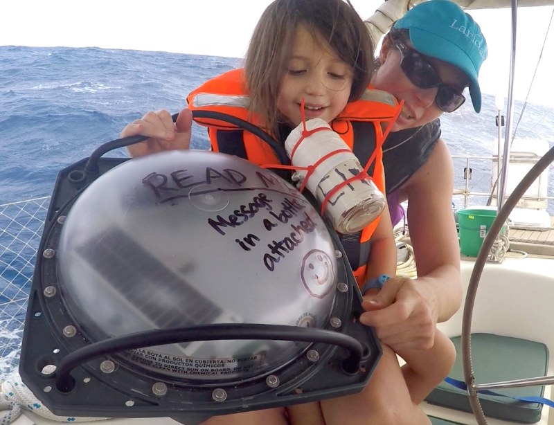
Writing the messages in the bottles was a fun group activity. Prior to leaving Scotland, we had a bon voyage party with our children where their friends wrote messages for inclusion in the bottles. Later, having joined Jimmy Cornell’s Barbados 50 rally to cross the Atlantic, we invited all of the kids and adults to write messages and draw pictures to include in the bottles. The three bottles were corked on the dock in Mindelo, an island in Cape Verde, and tied securely to the three drifting buoys. The drifters were given letter identifications after our kids’ names: Drifter A for Anneka, Drifter D for Dorian and Drifter E for Eliana. Each of our three children decorated their bottle and their assigned drifting buoy and added the words “Read Me” in large letters.
Drifter Buoy Deployment
We launched the message-filled bottles and drifters on days three, four and five (November 11-13, 2016) after departing Cape Verde on our 2,100-mile passage to Barbados. The drifters were deployed with an equal spacing of 2.5 degrees of longitude (approximately 145 miles apart at this latitude) at the positions: 15°N, 30°W (Drifter A); 14°N, 32.5°W (Drifter D); 13.5°N, 35°W (Drifter E). The drifters were deployed in age order of our children, but it helps that this is also (accidentally) in alphabetical order. When we set out the first buoy, the true-wind speed was about 25 to 30 knots from the northeast to east-northeast. The wind slowly diminished to about 25 knots for the second drifter, and to around 20 knots when the third drifter was launched.
Trained as a physical oceanographer, Eric was very excited to sail across the Atlantic Ocean and compare our knot-log speed (speed through the water) with our GPS speed (speed over ground) to try to estimate the ocean-current speed. However, within moments of departing the dock, we learned that Mindelo’s harbor inspires a lot of critters to make themselves at home on the hull, and our knot log was fouled with new growth. While surfing down waves with 35-knot gusts, funneling through São Vicente Canal between the islands of São Vicente and Santo Antão, serious soul-searching had to be done. Should we divert course to a protected anchorage in order to jump overboard to clean the speedo, or should we continue to enjoy the first few hours of our grand departure, sailing in close company with the 30 other boats around us in the rally, and live for the next two weeks without the knot-log data? After our recent showers and the knowledge that few showers were in store over the next few weeks, the fresh, clean feeling won out over a salty swim. We decided to continue on toward Barbados, sailing within sight of our fellow rally boats, but without a working log to be able to estimate ocean currents. Fortunately, the drifting GPS buoys were able to satiate our interest in the ocean currents, and following their course across the Atlantic Ocean has been fascinating for the entire family.
Tracking the Drifter Buoys
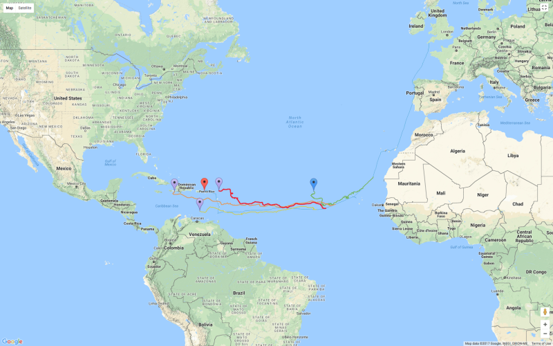
When the drifters were deployed, the trade winds were blowing from the typical direction of northeast to east-northeast at a speed of about 25 knots. For the first five days (and 100 miles of buoy drift), the buoys followed our path so closely that we received an email from Eric’s father asking if we had tied them to our transom and were towing them along. Even though the drifters were directly following our path, the buoys were not drifting exactly downwind. We had been sailing on a starboard tack, with a wind angle of about 140 degrees. Therefore, the buoys were following an angle about 40 degrees to the right (clockwise) of the wind direction. This is consistent with how surface currents should be oriented with respect to the prevailing wind direction.
The rotation of Earth causes the Coriolis force to direct the near-surface currents about 45 degrees to the right (clockwise) of the wind direction in the Northern Hemisphere. The clockwise rotation of currents continues with increasing depth to form a spiral pattern called the Ekman spiral. The Ekman spiral is a root of nontidal sea-level variations along the coasts, as well as the large ocean gyres in the open oceans and resulting currents, such as the Gulf Stream.
In late November, about 10 days after our departure from Cape Verde, the trade winds dropped substantially. Luckily, we were already west of the weakened wind zone, but many participants in the 2016 Atlantic Rally for Cruisers encountered a huge wind hole in the middle of the Atlantic Ocean. During this time of decreased wind forcing, the drifters started moving in a more northward direction toward the north-northwest, again turning to the right of their intended westward direction due to the Coriolis force. The north-northwest drift persisted for another 10 days before the typical east-northeast trade winds kicked back in and carried the drifters westward again.
As the drifters approached the Caribbean island chain, we expected that they would be pushed substantially northward. Before crossing the Atlantic, we had been warned to make sure we had achieved enough southing before we reached Barbados, because there could be a strong northwest current that would be difficult to fight against if we needed to get farther south to clear the shoals on the south side of Barbados. However, there was little evidence of any substantial northwest component of current until the drifters reached the longitude of Guyana (approximately 150 miles east of Barbados).
Amazingly, Drifter E passed within 5 miles of the south coast of Barbados, which was precisely the path that we navigated! It is highly unlikely that we could ever again release a drifter 2,000 miles upwind and expect it to arrive within 5 miles of our destination. Drifter D entered the Caribbean Sea by passing between Dominica and Îles des Saintes. This is a route heavily traveled by cruising sailboats, and it is fun to wonder how many fellow sailors passed right by the small drifter without noticing it. Drifter A, released first, was most recently reported to be passing north of the Caribbean island chain. Over the past six months, the drifters have traveled approximately 2,200 miles. After all of that distance, Drifter D and Drifter E were only about 250 miles apart.
In summary, the drifters moved with the surface currents at an average speed of approximately half a knot. In times of increased trade winds, sailors can expect stronger surface currents that are oriented about 45 degrees to the right of the prevailing trade-wind direction in the Northern Hemisphere. However, if the trade winds relax, it is important to note that the surface currents can weaken, change direction or even reverse against you for a short period of time.
Where Will the Messages Go Next?
All three drifters were deployed within about 300 miles of one another. However, over the past six months, and 2,200 miles later, two have taken a similar path into the Caribbean Sea, and one has drifted north of the Caribbean. Drifter A, having been carried north of the Caribbean, will likely slowly continue northwestward toward the Bahamas, carried by the prevailing southeast trade winds in the spring and summer season. Eventually, it will likely be entrained in the Gulf Stream and join the ocean highway back across the Atlantic toward Ireland.
Drifters D and E are in the Caribbean Sea and will likely continue to drift slowly westward, possibly passing between Jamaica and Honduras, before getting caught in the headwaters of the Loop Current that originates between Cuba and the Yucatan Peninsula and entering the Gulf of Mexico.
There are a number of great online resources that show measured and predicted ocean surface currents around the globe. We encourage you to track our drifting messages in bottles, research the prevailing trade winds and surface currents, and place your bets on where the bottles will end up. We all look forward to learning of the lucky but unsuspecting beachcombers who find these unique creations.
– – –
In 2002-2003, Eric, a physical oceanographer, and Angela, a mathematician, crossed the Pacific, from Seattle to New Zealand. Nearly 15 years and three children later, the family crossed the Atlantic from Scotland to the Caribbean aboard Laridae, their 1995 Westerly 49.


